January 14 2019
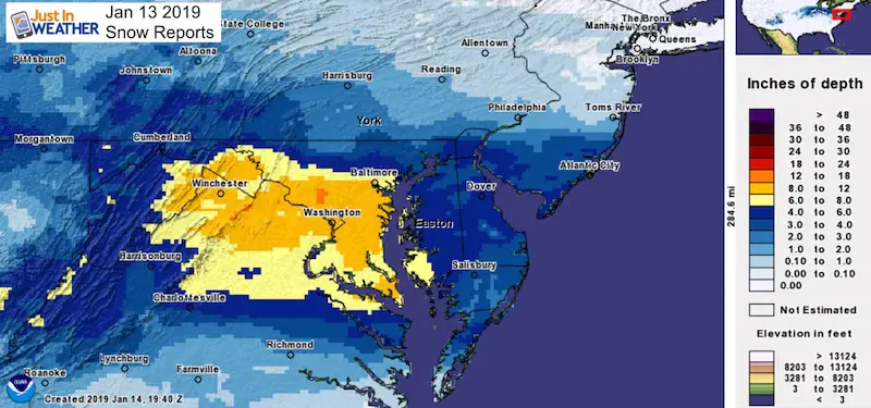
The final snow reports are in for the first snowstorm of 2019. There is now doubt this was an overachiever, but we were leaning that way going in to it. If you had followed my forecast, then you saw my increase in totals going along with my thoughts that the storm itself would be stronger and farther north. That is what happened. This final snow report shows that northern areas did verify with the snow expectations, but some central Maryland regions got a lot more.
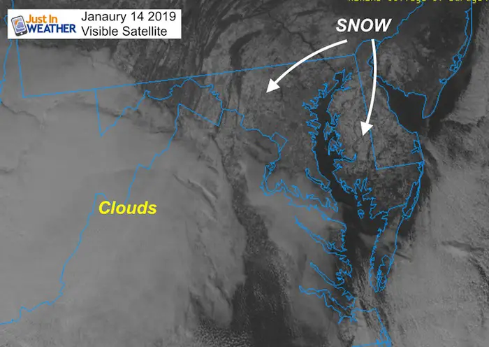
Snow Cover Seen From Space
Needless to say, snow covered the ground and when the sky cleared this afternoon, the visible satellite image showed the snow from space
Below is a breakdown of how much snow fell between Saturday January 12 and Sunday January 13 2019. We are still beta testing our interactive mapping of snow reports compared to my forecast. This feature includes reports from the four NWS Office Coverage areas for our region. These include: Baltimore/Washington; State College in PA, Mount Holly/Phildadelphia for Delmarva; and Wakefield VA for southern Maryland and southeast VA. The list below is primarily from NWS Baltimore/Washington. But I added a few others in where I could.
Grade My Forecast
I do ask that you take a look and then go back to the post you saw this link and give my forecast a grade. Overall I would say this was a B+, but if you are location specific, you may differ. I know some are strict to the numbers, while others will look at the timing that worked out well. The mention of the overachiever potential along with the second surge of Sunday snow may play a role in your grading. I would like to hear what you think.
Since the interactive map may be tough to navigate on some phones, I am also including my forecast map and maps of the reports from some areas in Maryland.
Please share your thoughts, best weather pics/video, or just keep in touch via social media
-
Facebook: Justin Berk, Meteorologist
-
Twitter: @JustinWeather
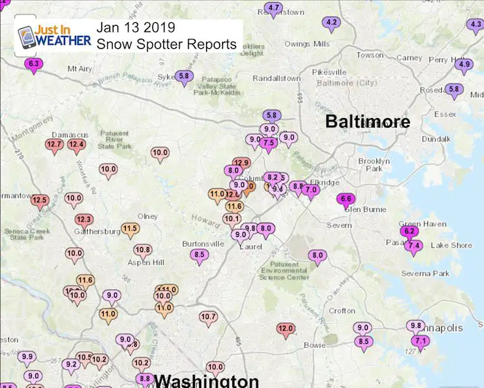
Key Top Snow Reports
- 6.6″ = BWI Airport (Baltimore)
- 9.0″ = Catonsville
- 9.8″ = Annapolis
- 10.2″ = Washington National Zoo
- 12.7″ Damascus
- 13″ = Columbia
Snow Map Project Partner

Supporter of Just In Power Kids and Maryland Trek 6 in August 2019.
With the help of my friend Jarod Scott, we put together this interactive snow map for our region. You should be able to see my forecast and zoom in to your area to compare.
Eventually we will build in more interactive features for you to be part of the reporting. Please let us know what you think. #FITF
Interactive Snow Map
- + to Zoom In
- – to Zoom Out
Click each dot to read the latest snow report. Notice the time stamp when it was posted.
My forecast map and NWS forecasts should be able to be toggled to compare
If you are on a phone, turn sideways for better viewing
My Final Snow Forecast: Before The First Flakes Fell

The 6 to 12 inch range moved way north into Montgomery and Howard Counties in Maryland. The Pennsylvania locations were low, mostly just under 3 inches.
- A: 6 to 12 inches
- B: 5 to 8 inches
- C: 3 to 6 inches
- D: 1 to 3 inches
Snow Spotter List (From NWS Baltimore/Washington)
********************STORM TOTAL SNOWFALL********************

LOCATION          STORM TOTAL     TIME/DATE   COMMENTS
                     SNOWFALL           OF
                     /INCHES/   MEASUREMENT

DISTRICT OF COLUMBIA

...District of Columbia...
   Somerset 1 SE         10.8   915 PM  1/13  Trained Spotter
   National Zoo 1 WSW    10.2  1028 PM  1/13  Trained Spotter
   Rock Creek             8.8   952 PM  1/13  Trained Spotter

MARYLAND

...Allegany County...
   Ridgeley 1 NW          6.5  1149 PM  1/13  Trained Spotter
   Frostburg 2 ENE        5.5  1252 AM  1/14  Trained Spotter
   Wolfe Mill 2 NNE       3.4   755 PM  1/13  Trained Spotter

...Anne Arundel County...
   Annapolis 1 NW         9.8  1100 PM  1/13  Trained Spotter
   Crownsville 3 SSW      9.0   900 PM  1/13  Trained Spotter
   Riva 2 WNW             8.5   930 PM  1/13  Trained Spotter
   Fort Meade 2 ESE       8.0   935 PM  1/13  Trained Spotter
   Upper Marlboro 4 E     7.7  1145 PM  1/13  Trained Spotter
   Chelsea Beach  NNE     7.4   750 PM  1/13  Trained Spotter
   Annapolis 1 S          7.1   630 PM  1/13  Trained Spotter
   Bwi Airport            6.6  1200 AM  1/14  Airport
   Green Haven 1 ESE      6.2   830 PM  1/13  Trained Spotter

...Baltimore County...
   Catonsville 2 WNW      9.0   926 PM  1/13  Trained Spotter
   Middle River 1 N       5.8   921 PM  1/13  Trained Spotter
   Daniels 1 ESE          5.8   925 PM  1/13  Trained Spotter
   White Marsh 2 E        4.9  1201 AM  1/14  Trained Spotter
   Glyndon 1 E            4.7  1034 PM  1/13  Trained Spotter
   Upper Falls 1 NNE      4.3   900 PM  1/13  Trained Spotter
   Brooklandville 2 NNW   4.2   715 PM  1/13  Trained Spotter
   Long Green 2 NW        3.3   830 PM  1/13  Trained Spotter

...Calvert County... Dunkirk 2 SSW 9.5 1005 PM 1/13 Trained Spotter Prince Frederick 1 S 7.8 1100 PM 1/13 Trained Spotter Huntingtown 2 WNW 7.2 835 PM 1/13 Trained Spotter Huntingtown 2 SW 7.0 1036 PM 1/13 Trained Spotter ...Carroll County... Sykesville E 5.8 900 PM 1/13 Trained Spotter ...Charles County... Dentsville 1 SW 8.6 130 AM 1/14 Trained Spotter Waldorf 2 W 6.8 630 PM 1/13 Trained Spotter ...Frederick County... Point of Rocks 1 NE 10.2 815 PM 1/13 Trained Spotter Adamstown 1 ESE 9.5 1033 PM 1/13 Trained Spotter Park Mills 3 ESE 9.0 1054 PM 1/13 Trained Spotter Bloomfield 2 WSW 8.0 948 PM 1/13 NWS Employee New Market N 6.3 1045 PM 1/13 Trained Spotter Walkersville 1 E 6.2 746 PM 1/13 Trained Spotter Sabillasville 2 SSE 4.5 800 PM 1/13 Trained Spotter ...Howard County... Columbia 13.0 1028 PM 1/13 NWS Employee Columbia 2 N 12.9 1145 PM 1/13 Trained Spotter Simpsonville E 12.0 1130 PM 1/13 Trained Spotter Simpsonville 1 SSE 11.6 1030 PM 1/13 Trained Spotter Elkridge 2 W 11.3 1100 PM 1/13 Trained Spotter Simpsonville 1 W 11.0 945 PM 1/13 Trained Spotter Scaggsville 1 ENE 10.1 1150 PM 1/13 NWS Employee Roxbury Mills 2 ESE 10.0 930 PM 1/13 Trained Spotter Savage 1 WSW 9.8 1100 PM 1/13 Trained Spotter Elkridge 2 WSW 9.8 820 PM 1/13 Trained Spotter Savage 1 ESE 9.6 805 PM 1/13 Trained Spotter Elkridge 2 WNW 9.5 1005 PM 1/13 Trained Spotter Columbia W 9.0 745 PM 1/13 Trained Spotter Ellicott City 2 NE 9.0 930 PM 1/13 Trained Spotter Ellicott City 9.0 1148 PM 1/13 Broadcast Media Elkridge 8.8 1055 PM 1/13 NWS Employee Elkridge 3 WNW 8.2 830 PM 1/13 Trained Spotter Columbia 2 NW 8.0 823 PM 1/13 Trained Spotter Jessup 2 WSW 8.0 650 PM 1/13 Trained Spotter Oella 1 WSW 7.5 715 PM 1/13 Trained Spotter Hanover ENE 7.0 800 PM 1/13 Trained Spotter...Montgomery County... Damascus 3 SSW 12.7 151 AM 1/14 Co-Op Observer Germantown 12.5 1146 PM 1/13 Private Company Damascus 1 SE 12.4 1100 PM 1/13 Trained Spotter Washington Grove 1 N 12.3 843 PM 1/13 Trained Spotter Rockville 2 SSW 11.6 930 PM 1/13 Trained Spotter Olney 1 S 11.5 940 PM 1/13 Trained Spotter Four Corners 1 N 11.2 615 PM 1/13 Trained Spotter Bethesda 1 NNW 11.0 1000 PM 1/13 Trained Spotter Four Corners 1 S 11.0 940 PM 1/13 Trained Spotter White Oak 1 W 11.0 800 PM 1/13 Trained Spotter Norbeck 1 ESE 10.8 1000 PM 1/13 Trained Spotter Potomac 1 N 10.8 1100 PM 1/13 Trained Spotter Laytonsville 1 NE 10.0 744 PM 1/13 Trained Spotter Montgomery Village 10.0 832 PM 1/13 NWS Employee Potomac 1 ENE 10.0 930 PM 1/13 Trained Spotter Rockville 2 WNW 10.0 1000 PM 1/13 Trained Spotter Four Corners 1 NNW 10.0 640 PM 1/13 Trained Spotter Garrett Park 1 WSW 9.0 102 AM 1/14 Trained Spotter Somerset 9.0 725 PM 1/13 Trained Spotter Fairland 1 NNE 8.5 735 PM 1/13 Trained Spotter
...Prince Georges County...
   Glenn Dale 2 ESE      12.0   907 PM  1/13  Trained Spotter
   College Park 1 ENE    10.7  1000 PM  1/13  Trained Spotter
   Cheverly  S           10.0  1030 PM  1/13  Trained Spotter
   Laurel 2 N             9.0  1243 AM  1/14  Trained Spotter
   Marlton 1 WSW          8.8   755 PM  1/13  Trained Spotter

...St. Marys County...
   Hollywood 1 SSW        8.6  1115 PM  1/13  Trained Spotter
   Callaway 2 W           7.0   942 PM  1/13  Trained Spotter

...Washington County...
   Boonsboro 3 NNE        7.9  1030 PM  1/13  Trained Spotter
   Hancock 1 ESE          5.0   900 PM  1/13  Trained Spotter
   Long Meadow 1 SSE      4.5   900 PM  1/13  Trained Spotter
PENNSYLVANIA

...ADAMS COUNTY...
   CASHTOWN 1S            3.0   700 AM  1/13  CO-OP OBSERVER
   CASHTOWN               3.0   700 AM  1/13  CO-OP OBSERVER
   ARENDTSVILLE           2.8   700 AM  1/13  COCORAHS
   1 SSW EAST BERLIN      2.3   730 AM  1/13  COCORAHS
   YORK SPRINGS           2.0   700 AM  1/13  COCORAHS
   HANOVER                2.0   800 AM  1/13  CO-OP OBSERVER
|
..YORK COUNTY... 1 S YORK 3.5 800 AM 1/13 SOCIAL MEDIA SPRING GROVE 2.5 830 AM 1/13 TRAINED SPOTTER 1 S NEW SALEM 2.5 839 AM 1/13 TRAINED SPOTTER 1 ESE MANCHESTER 2.3 700 AM 1/13 COCORAHS 3 W MANCHESTER 2.1 700 AM 1/13 COCORAHS WEST MANHEIM 2.0 850 AM 1/13 TRAINED SPOTTER 1 WSW EMIGSVILLE 2.0 700 AM 1/13 COCORAHS HANOVER 2.0 800 AM 1/13 CO-OP OBSERVER |
..LANCASTER COUNTY... HOLTWOOD 2.0 800 AM 1/13 TRAINED SPOTTER MILLERSVILLE 2.0 700 AM 1/13 CO-OP OBSERVER SAFE HARBOR 2.0 800 AM 1/13 TRAINED SPOTTER 2 SSE ADAMSTOWN 1.8 700 AM 1/13 COCORAHS LITITZ 1.8 800 AM 1/13 COCORAHS 4 NE LANCASTER 1.8 737 AM 1/13 TRAINED SPOTTER |
VIRGINIA

...Albemarle County...
   Charlottesville 1 W    4.7  1004 PM  1/13  Public

...Arlington County...
   Reagan National Apt   10.3  1259 AM  1/14  Airport
   Ballston 1 SW         10.0   800 PM  1/13  Trained Spotter
   Westover 1 SE          9.8  1005 PM  1/13  Trained Spotter
   Ballston 1 SSW         8.3   800 PM  1/13  Trained Spotter

...City of Alexandria...
   Alexandria 1 ESE       8.0  1014 PM  1/13  Trained Spotter
   Alexandria 1 W         7.9   930 PM  1/13  Trained Spotter

...City of Fairfax...
   Fairfax 1 N            9.2   657 PM  1/13  NWS Employee
   Fairfax 2 WNW          9.0   700 PM  1/13  Trained Spotter

...City of Falls Church...
   Falls Church 1 W       7.8  1005 PM  1/13  Trained Spotter

...City of Manassas...
   Manassas 3 SSE         7.8  1215 AM  1/14  Trained Spotter

...City of Manassas Park...
   Manassas Park 1 SW     8.8  1203 AM  1/14  Trained Spotter

...Clarke County...
   Berryville 1 NNW       8.0  1115 PM  1/13  Trained Spotter
   Berryville 1 NE        6.0   715 PM  1/13  Trained Spotter

...Fairfax County...
   Chantilly 1 ENE       10.9   142 AM  1/14  NWS Employee
   Merrifield 1 SE       10.5   730 PM  1/13  Trained Spotter
   Chantilly 3 N         10.5  1148 PM  1/13  NWS Employee
   McLean                10.5   830 PM  1/13  Trained Spotter
   Vienna 1 SSW          10.3   145 AM  1/14  NWS Employee
   Langley 1 SE          10.2  1100 PM  1/13  Trained Spotter
   Chantilly 2 N         10.2   717 PM  1/13  Trained Spotter
   Herndon 1 NNE         10.1  1030 PM  1/13  NWS Employee
   Wolf Trap  S           9.9   825 PM  1/13  Trained Spotter
   Reston 2 SW            9.7  1115 PM  1/13  Trained Spotter
   Baileys Crossroads 1   9.5   745 PM  1/13  Trained Spotter
   McLean 2 SW            9.2   658 PM  1/13  Trained Spotter
   Chantilly 3 NE         9.2   630 PM  1/13  Trained Spotter
   Herndon 2 ENE          9.0  1035 PM  1/13  Trained Spotter
   Vienna 1 WNW           9.0   750 PM  1/13  Trained Spotter
   Franconia 1 SSW        9.0  1115 PM  1/13  Trained Spotter
   Reston 2 N             9.0  1000 PM  1/13  Trained Spotter
   Annandale  S           8.9  1045 PM  1/13  Trained Spotter
   Rose Hill  ENE         8.6   800 PM  1/13  Trained Spotter
   Centreville  W         8.5   945 PM  1/13  Trained Spotter
   Oakton 1 WSW           8.5   805 PM  1/13  Trained Spotter
   Lincolnia 2 S          8.2   850 PM  1/13  Trained Spotter
   Franconia 1 N          8.0   139 AM  1/14  Trained Spotter

...Frederick County...
   Winchester 2 S         7.0  1235 AM  1/14  Trained Spotter

...Highland County...
   Monterey 2 WSW         4.0   904 PM  1/13  Trained Spotter

...Loudoun County...
   Leesburg 1 N          11.4  1021 PM  1/13  Trained Spotter
   Leesburg 2 E          11.0   945 PM  1/13  Trained Spotter
   Purcellville 1 SW     10.8  1144 PM  1/13  Trained Spotter
   Leesburg 1 ESE        10.8   822 PM  1/13  NWS Office
   Dulles International  10.6  1200 AM  1/14  Airport
   Ashburn 1 NNE         10.5   940 PM  1/13  NWS Employee
   Leesburg 1 NNW        10.0   750 PM  1/13  Trained Spotter
   Arcola 1 NNE           9.5   625 PM  1/13  Trained Spotter
   Middleburg 2 NW        9.5   900 PM  1/13  Trained Spotter
   Hughesville 1 ESE      9.5  1015 PM  1/13  Trained Spotter
   Round Hill 1 WNW       9.3  1045 PM  1/13  Trained Spotter
   Leesburg 2 NW          9.0   706 PM  1/13  Trained Spotter
   Purcellville           8.6   800 PM  1/13  NWS Employee
   Sterling Park 2 ENE    8.5   900 PM  1/13  Trained Spotter

...Orange County...
   Flat Run 1 N           5.5   730 PM  1/13  Trained Spotter

...Page County...
   Panorama 2 WSW         6.0   800 PM  1/13  Trained Spotter

...Prince William County...
   Woolsey 1 SW           9.1   950 PM  1/13  Trained Spotter
   Greenwich 2 ENE        9.0  1133 PM  1/13  Trained Spotter
   Independent Hill 2 E   9.0   945 PM  1/13  Trained Spotter
   Sudley                 8.0  1254 AM  1/14  NWS Employee
   Gainesville 2 SSE      7.8   930 PM  1/13  Trained Spotter
   Dumfries 1 ENE         7.5  1149 PM  1/13  Trained Spotter
   Nokesville             7.3   700 PM  1/13  NWS Employee
   Lake Ridge 4 WNW       6.3   900 PM  1/13  Trained Spotter

...Stafford County...
   Brooke 1 ESE           7.4  1159 PM  1/13  Trained Spotter
   White Oak 5 SSW        7.1   950 PM  1/13  Trained Spotter
   Aquia 1 NNE            7.0  1220 AM  1/14  Trained Spotter
   Glendie 2 SSE          7.0  1024 PM  1/13  Trained Spotter
   White Oak 3 SSE        6.5  1000 PM  1/13  CoCoRaHS
   Garrisonville 1 ESE    6.2  1030 PM  1/13  Trained Spotter
   Garrisonville 1 SSW    6.1  1008 PM  1/13  Trained Spotter
   Roseville 2 WNW        6.0  1040 PM  1/13  Trained Spotter

...Warren County...
   Karo 1 WSW             8.1   123 AM  1/14  Trained Spotter
   Nineveh 2 NNE          7.5  1159 PM  1/13  Trained Spotter

WEST VIRGINIA

...Berkeley County...
   Martinsburg 2 E       11.7  1000 PM  1/13  NWS Employee
   Martinsburg Arpt 1 N  10.6  1144 PM  1/13  Trained Spotter
   Bunker Hill  SE        9.5  1125 PM  1/13  Trained Spotter
   Glengary 1 ESE         7.0   804 PM  1/13  Trained Spotter
   Falling Waters 2 NW    6.3   923 PM  1/13  Trained Spotter

...Hampshire County...
   Capon Bridge 3 WSW    10.0   730 PM  1/13  Trained Spotter

...Hardy County...
   Wardensville 3 E       9.0  1205 AM  1/14  Trained Spotter

...Jefferson County...
   Shepherdstown 4 NNW    7.0   915 PM  1/13  Trained Spotter
   Halltown 2 N           6.8   705 PM  1/13  Trained Spotter

...Mineral County...
   Keyser                 5.8  1003 PM  1/13  Trained Spotter

...Morgan County...
   Smith Crossroads 1 W   4.7   820 PM  1/13  Trained Spotter
Snowstix- We Need You To Measure Snow Too
We are giving 10% of each sale to Just In Power Kids: Providing FREE holistic care for pediatric oncology patients.

Snow Day Kit
NEW: Individual Items Are Now Available A La Carte.

FITF and SnowStix Available NOW

Keep In Touch Every Day
Just in case you don’t get all posts on your social media feed, stay up to date with the latest info…
Click here to sign up for email alerts…. Be the first to hear any new weather forecasts
Please share your thoughts, best weather pics/video, or just keep in touch via social media
-
Facebook: Justin Berk, Meteorologist
-
Twitter: @JustinWeather
-
Instagram: justinweather
Related Links:
Winter Outlook
My Winter Outlook 2018-19: Multiple Nor’Easters and more snow

Interactive Snow Report
November 15 Snow Reports- Interactive Map Compared To My Forecast

Winter Snow And Top 5 Wet Years
Snowfall Seasons at Beginning and End of Top 5 Wet Years In Baltimore

Related Winter Outlooks
Solar Cycle: When Sun Spots Are Low We Get More Snow
El Nino Modoki May Enhance Snow Chances
Sweet Spot: Hitting 70ºF on Halloween is followed by more winter snow
Will A Wet Summer Bring A Snowy Winter?
NOAA Winter 2018-2019 Outlook Explained: This Actually Supports Snow
Winter Outlook From Two Different Farmers Almanacs
Maryland Winters: Snowfall Maps and Baltimore Snow History
