Monday January 14 2019
The last of the snow was departing Ocean City this morning and cold air has frozen up the entire region left behind. Many schools in Maryland are closed where snow overachieved for sure. Lighter amounts did verify my forecast north and that is where 2 hour school delays with reevaluations this morning are in place. If you have to head to work on time, there have been accidents on icy roads. See the morning conditions and forecast below.
Snow Totals Sunday Jan 13 2019
Here is a quick look at the top snow spots. Highest snow reports were between Washington and Baltimore where nearly foot of snow fell in Howard and Montgomery Counties. I will have a full snow wrap up in my next report:
Key Snow Reports
- 6.6″ = BWI Airport (Baltimore)
- 9.0″ = Catonsville
- 9.8″ = Annapolis
- 10.2″ = Washington National Zoo
- 12.7″ Damascus
- 13″ = Columbia

Outlook: More Winter Storms And The Polar Vortex
There are a few more winter weather events later this week, but not al models agree it will be all snow. I don’t want to feed the hype machine, but rather show you there are a few possible results from a few more storms. That is just the beginning. There will likely be a lot of hype about the Polar Vortex getting dislodged and dropping towards the northern US at the end of this month. Winter is just getting started.
Local Weather Stats For January 14, 2019 in Baltimore
The hottest January temp was on this date in 1932 (79ºF)
Average High: 41ºF
Record High: 79ºF in 1932
Average Low: 24ºF
Record Low: -2ºF in 1912
*Record Snow: 6.4 in 1910
Sunrise: 7:24 AM
Sunset 5:06 PM
*Daylight = 1:22 longer than yesterday
*Bay Water Temperature = 38ºF at Thomas Pt. Light House
Morning Temperatures

High Temperatures


New Partner
Buchanan Kia of Westminster is a supporter of Just In Power Kids and Maryland Trek 6 in August 2019.
Weather Week
Much of this week will be quiet and cold. The drill will be some daytime thawing and then refreezing and icy spots each night/morning.
Thursday Night/Friday Morning
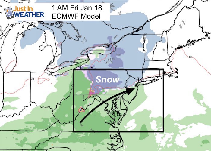
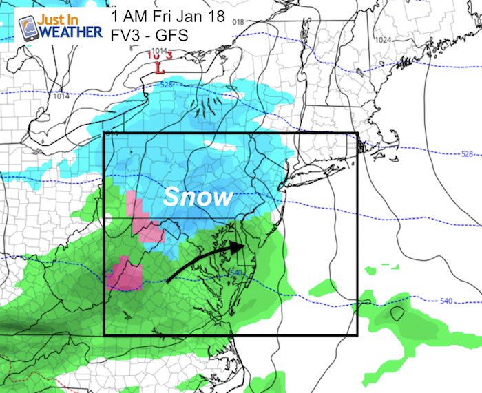
Nothing set in stone here. The latest modeling shows a northern push (hey, we just did that). This time it could bring the rain line farther north. The European Model has us with rain with the wintry stuff in PA and the mountains. Meanwhile the FV3-GFS still has the northern zones of Maryland in the snow.
| European Model: Mostly Rain? | FV3 – North For Northern Suburbs |
 |
 |
Animation: Thursday 7 PM to Friday 1 PM
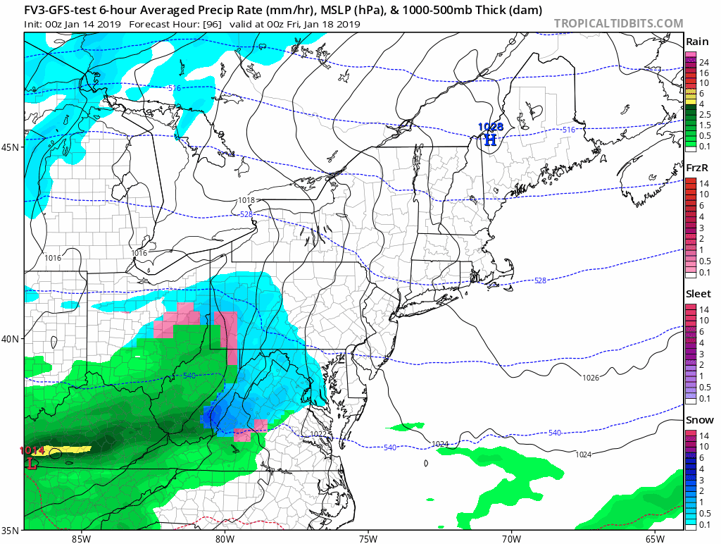
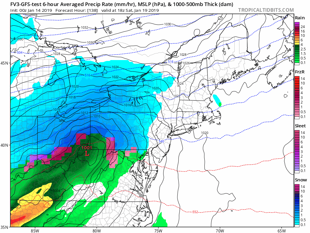
Weekend Storm?
Here we see the European Model still pushing systems farther north and keeping us wet. But the FV3 is part of the contingent making it more complicated. Below you will see rain turning to ice and snow on Sunday.
Rain with Ice and Snow North?

OR
Rain CHANGING to ICE and SNOW


Animation: Saturday 1 PM to Sunday 7 PM

We are giving 10% of each sale to Just In Power Kids: Providing FREE holistic care for pediatric oncology patients.
Outlook: Winter Just Getting Started
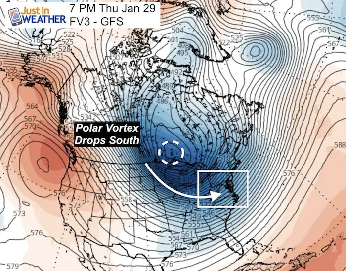
You may have already heard about the return of the Polar Vortex. Now it’s time to talk about it here. It looks like the upper level pattern supports this getting dislodged and dropping south towards the northern US. This map is two weeks away, but the end of the month is when we expect to get into the deep arctic air. This will inject a lot of energy to fuel many potential storms.
Long Range Animation
I normally don’t show this but I wanted you to see how this translates to potential active winter weather. Do not lock in on dates and promises of each event. However there will be an increase in frequency of snow and ice storms for the eastern US.
January 27 to 29
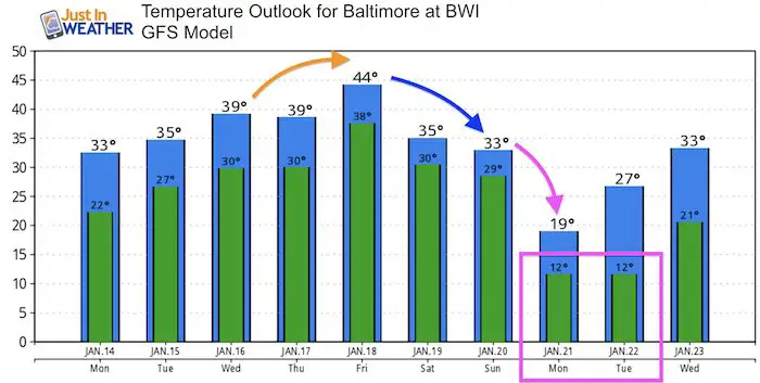
Temperature Outlook
Maybe These Snow Day Kits Worked- Get in on the action
NEW: Individual Items Are Now Available A La Carte.

FITF and SnowStix Available NOW

Keep In Touch Every Day
Just in case you don’t get all posts on your social media feed, stay up to date with the latest info…
Click here to sign up for email alerts…. Be the first to hear any new weather forecasts
Please share your thoughts, best weather pics/video, or just keep in touch via social media
-
Facebook: Justin Berk, Meteorologist
-
Twitter: @JustinWeather
-
Instagram: justinweather
Keep In Touch Every Day
Click here to sign up for email alerts…. Just in case you don’t get the post on your social media feed
Related Links:
Winter Outlook
My Winter Outlook 2018-19: Multiple Nor’Easters and more snow

Interactive Snow Report
November 15 Snow Reports- Interactive Map Compared To My Forecast

Winter Snow And Top 5 Wet Years
Snowfall Seasons at Beginning and End of Top 5 Wet Years In Baltimore

Related Winter Outlooks
Solar Cycle: When Sun Spots Are Low We Get More Snow
El Nino Modoki May Enhance Snow Chances
Sweet Spot: Hitting 70ºF on Halloween is followed by more winter snow
Will A Wet Summer Bring A Snowy Winter?
NOAA Winter 2018-2019 Outlook Explained: This Actually Supports Snow
Winter Outlook From Two Different Farmers Almanacs
Maryland Winters: Snowfall Maps and Baltimore Snow History
