Friday January 11 2019
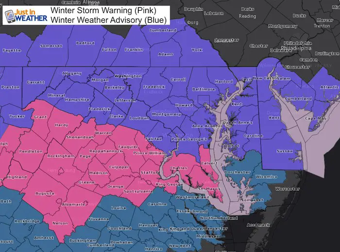
As expected, the Winter Weather Advisory was issued for most of our area starting Saturday Evening. The Winter Storm Warning is for southern areas and begins Saturday morning in the mountains, but not until Saturday evening in St. Mary’s County Maryland. My initial snow totals are the same and now The National Weather Service has increased their snow amounts just a little to fill the upper end of my ranges. Compare the snow maps below.
Can this overachieve? That is the question I have been getting most lately. I have seen the NAM 3 Km shift the heavier snow north close to Rt 50 in MD as shown below. If we get more snow, then it will be with a shift north AND the Sunday Low getting better organized.
Winter Storm Warning
This includes: Charles, Calvert, and St. Mary’s Counties in Maryland. It gets a little complicated as the system is moving west to East. This Warning starts in the morning in the mountains. Then Charles Co begins at 4 PM. Calvert and St. Mary’s begins at 7 PM
Winter Weather Advisory
Carroll, Fredrick, Howard Co in Maryland and metro Washington begins at 4 PM
Baltimore east begins at 7 PM
Keep In Touch Every Day
Just in case you don’t get all posts on your social media feed, stay up to date with the latest info…
Click here to sign up for email alerts…. Be the first to hear any new weather forecasts
Snow Simulation Saturday —> slider
See my Timeline Notes below
[metaslider id=70569]
Snow Simulation Sunday —> slider
[metaslider id=70586]
Snow Total Forecast
The latest snow forecast from NAM 3 Km has shifted the heavier snow north. It now has Washington and Annapolis in the 6 inch potential. If we get this storm to overachieve, it will be with a shift north and the Sunday Low getting better organized.
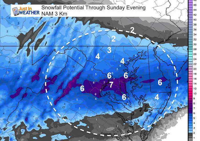
This is close to my first call map I showed this morning. I went higher in the mountains and Southern Maryland.
My Call For Snowfall

- A: 6 to 8 inches in the mountains
- B: 3 to 6 inches Southern VA to southern MD. This range is due to any mixing or rain early, but more snow later. Coastal Areas will get rain, but end with a burst of snow. I included them in this zone with the chance to catch up at the finish.
- C: 2 to 4 inches. Metro Washington, Annapolis, Baltimore, to York PA
- D: Dusting to 2 inches. These areas will be on the northern edge and dry air form the arctic high needs to be considered eroding away what falls.
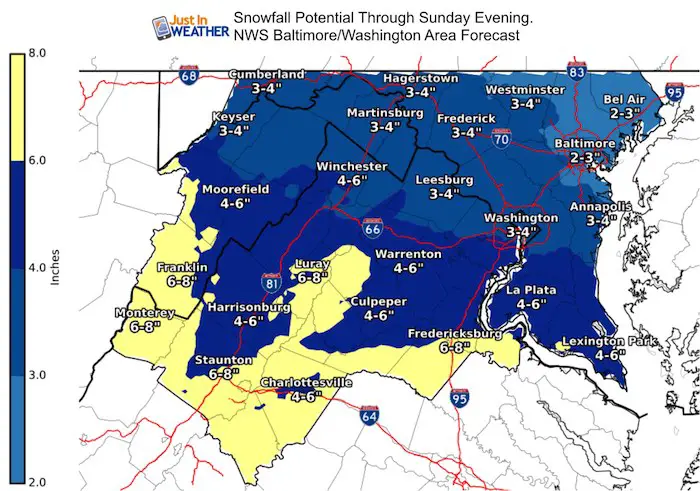
NWS Snow Forecast Updated
Snowstix- We Need You To Measure Snow Too
We are giving 10% of each sale to Just In Power Kids: Providing FREE holistic care for pediatric oncology patients.

Snow Timeline Notes:
Saturday Afternoon:
Flurries or light snow. The onset between 2 and 4 PM west of the cities depends on how dry the air is. I see snow creeping in on radar, but it could be virga.
Saturday Evening:
Snowing in most areas around and after sunset. Maybe a few hours later in Southern PA.
Travel will be impacted and I expect many events will cancel. Snow will get heavier late evening and overnight.
Sunday Morning:
Most accumulation will be done central Maryland and north between sunrise and noon.
Some snow may linger later.
Southern Maryland will continue to get snow into the afternoon.
Sunday Night/Monday Morning
The only issue I see on roads will be late cleanup (some areas limit crews for cut down on overtime) and refreezing at night.
Here is a new product they posted this morning about their confidence and the impact.
Snow Day Kit
NEW: Individual Items Are Now Available A La Carte.

Our ritual the night before a storm is finally in one kit. Maybe if more Maryland kids had this, the storm would reach us 🙂
- This includes a very soft raglan Tee printed inside out with #FITF AND the check list, #FITF spoon for under your pillow, ice cube tray with snowflake shapes, chalk, a #FITF wrist-band, a mini SnowStix, and a bag to carry it all in.
- This will also help us give a free Snow Day Kit to each of the Just In Power Kids.
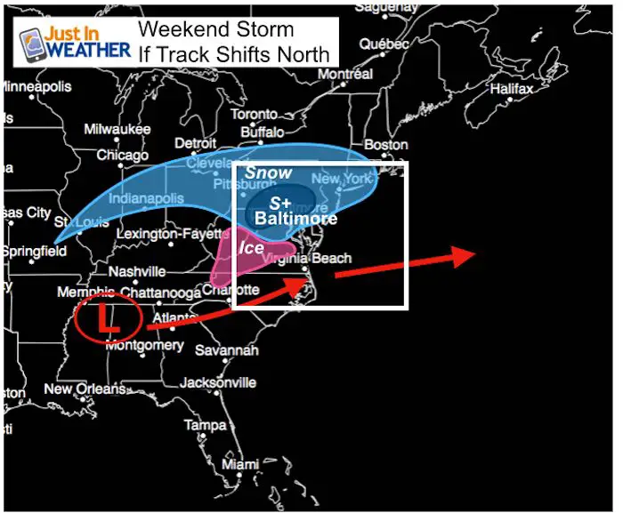
One of two scenarios
| Current Model Average Expectation | If The Storm Verifies Farther North |
 |
 |
New Partner
I’d like to welcome Buchanan Kia of Westminster: Now a supporter of Just In Power Kids and Maryland Trek 6 in August 2019. Soon we will be showing you why we developed this relationship with a local business that my wife and I sincerely trust.

FITF and SnowStix Available NOW

Keep In Touch Every Day
Just in case you don’t get all posts on your social media feed, stay up to date with the latest info…
Click here to sign up for email alerts…. Be the first to hear any new weather forecasts
Please share your thoughts, best weather pics/video, or just keep in touch via social media
-
Facebook: Justin Berk, Meteorologist
-
Twitter: @JustinWeather
-
Instagram: justinweather
Keep In Touch Every Day
Click here to sign up for email alerts…. Just in case you don’t get the post on your social media feed
Related Links:
Winter Outlook
My Winter Outlook 2018-19: Multiple Nor’Easters and more snow

Interactive Snow Report
November 15 Snow Reports- Interactive Map Compared To My Forecast

Winter Snow And Top 5 Wet Years
Snowfall Seasons at Beginning and End of Top 5 Wet Years In Baltimore

Related Winter Outlooks
Solar Cycle: When Sun Spots Are Low We Get More Snow
El Nino Modoki May Enhance Snow Chances
Sweet Spot: Hitting 70ºF on Halloween is followed by more winter snow
Will A Wet Summer Bring A Snowy Winter?
NOAA Winter 2018-2019 Outlook Explained: This Actually Supports Snow
Winter Outlook From Two Different Farmers Almanacs
Maryland Winters: Snowfall Maps and Baltimore Snow History
