Saturday January 12 2019
If you saw my post lat night on Facebook or Twitter, then you know I thought I might be upping the snow totals. That was due to a stronger, larger storm appears to take that track a little farther north. So here we are before the arrival of the storm and there is a lot of information to share. However, I want to keep the text down to a minimum. There are plenty of maps below to browse, but let’s start with the official NWS Alerts.
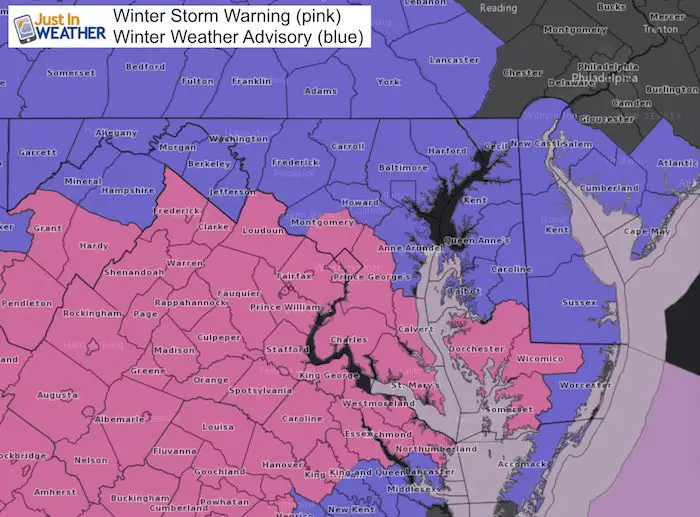
Winter Storm Warning and Winter Weather Advisory
Updates:
The Winter Storm Warning now includes metro Washington for eastern Montgomery and PG Counties into Southern Maryland and now the lower Eastern Shore.
The Winter Weather Advisory now reaches Lancaster in PA and the rest of Delmarva into southern New Jersey.
Keep In Touch Every Day
Just in case you don’t get all posts on your social media feed, stay up to date with the latest info…
Click here to sign up for email alerts…. Be the first to hear any new weather forecasts
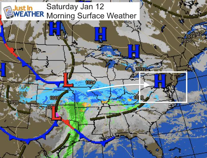
Morning Storm Map
Snow Timeline Notes:
I posted this yesterday and not much has changed
Saturday Afternoon:
Flurries or light snow. The onset between 2 and 4 PM west of the cities depends on how dry the air is. I see snow creeping in on radar, but it could be virga. Steady snow may pick up quickly.
Saturday Evening:
- Snowing in most areas around and after sunset. Maybe a few hours later in Southern PA.
- Travel will be impacted and I expect many events will cancel. Snow will get heavier late evening and overnight.
Sunday Morning:
- *Moderate to heavy snow may linger in the morning.
- Most accumulation by noon.
- Some snow may last into the afternoon.
Sunday Night/Monday Morning
The only issue I see on roads will be late cleanup (some areas limit crews for cut down on overtime) and refreezing at night.
Snow Day Kit
NEW: Individual Items Are Now Available A La Carte.

Our ritual the night before a storm is finally in one kit. Maybe if more Maryland kids had this, the storm would reach us 🙂
- This includes a very soft raglan Tee printed inside out with #FITF AND the check list, #FITF spoon for under your pillow, ice cube tray with snowflake shapes, chalk, a #FITF wrist-band, a mini SnowStix, and a bag to carry it all in.
- This will also help us give a free Snow Day Kit to each of the Just In Power Kids.
Local Weather Stats For January 12, 2019 in Baltimore
Average High: 41ºF
Record High: 70ºF in 2017
Average Low: 24ºF
Record Low: 1ºF in 1981
*Record Snow: 6.0″ in 1996
Sunrise: 7:25 AM
Sunset 5:04 PM
*Daylight = 1:15 longer than yesterday
*Bay Water Temperature = 40ºF at Thomas Pt. Light House
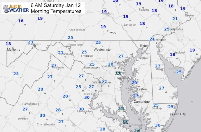
Morning Temperatures
The ground has sufficiently cooled and temps will remain cold all day. Most area will support stickage when the snow begins.
Snow Timeline
Note: This product often shows ‘green’ on the leading edge of winter events, but that might be flurries. The main snow will begin mid afternoon.
Saturday —> slider
[metaslider id=70620]
Sunday —> slider
[metaslider id=70637]
My Updated Call For Snowfall
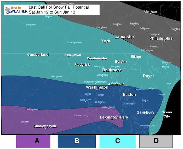
A: 4 to 8 inches
B: 3 to 6 inches (Rt 50 including Annapolis on the edge of this range)
C: 2 to 4 inches (Many in central MD will be on the upper end of this range)
D: Up to 2 inches
What The National Weather Service Offices Are Saying
This is the reason for the warning or advisory in your area. This slider may help show why our region does not always get warnings or advisories at the same time. Our region is solid among 4 different NWS Offices. Here is a look at
- Baltimore/Washington
- State College PA
- Wakefield VA
- Philadelphia
—> slider
[metaslider id=70660]
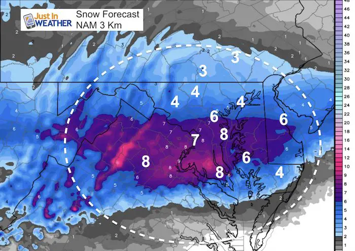
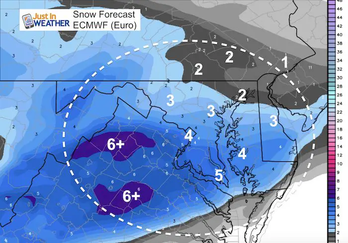
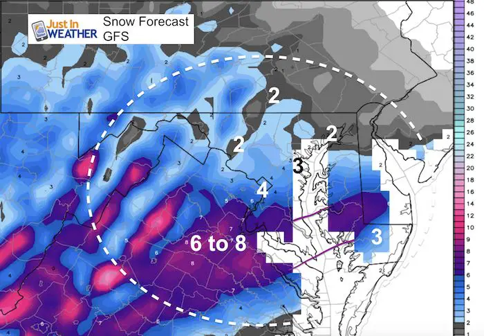
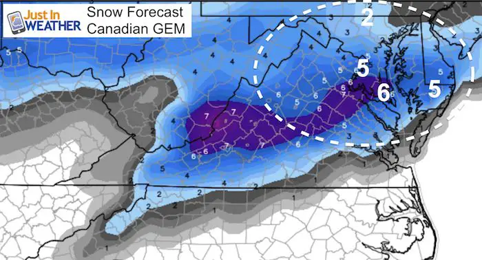
What The Models Are Saying
Snowstix- We Need You To Measure Snow Too
We are giving 10% of each sale to Just In Power Kids: Providing FREE holistic care for pediatric oncology patients.

New Partner
I’d like to welcome Buchanan Kia of Westminster: Now a supporter of Just In Power Kids and Maryland Trek 6 in August 2019. Soon we will be showing you why we developed this relationship with a local business that my wife and I sincerely trust.

FITF and SnowStix Available NOW

Keep In Touch Every Day
Just in case you don’t get all posts on your social media feed, stay up to date with the latest info…
Click here to sign up for email alerts…. Be the first to hear any new weather forecasts
Please share your thoughts, best weather pics/video, or just keep in touch via social media
-
Facebook: Justin Berk, Meteorologist
-
Twitter: @JustinWeather
-
Instagram: justinweather
Keep In Touch Every Day
Click here to sign up for email alerts…. Just in case you don’t get the post on your social media feed
Related Links:
Winter Outlook
My Winter Outlook 2018-19: Multiple Nor’Easters and more snow

Interactive Snow Report
November 15 Snow Reports- Interactive Map Compared To My Forecast

Winter Snow And Top 5 Wet Years
Snowfall Seasons at Beginning and End of Top 5 Wet Years In Baltimore

Related Winter Outlooks
Solar Cycle: When Sun Spots Are Low We Get More Snow
El Nino Modoki May Enhance Snow Chances
Sweet Spot: Hitting 70ºF on Halloween is followed by more winter snow
Will A Wet Summer Bring A Snowy Winter?
NOAA Winter 2018-2019 Outlook Explained: This Actually Supports Snow
Winter Outlook From Two Different Farmers Almanacs
Maryland Winters: Snowfall Maps and Baltimore Snow History
