Friday January 11 2019
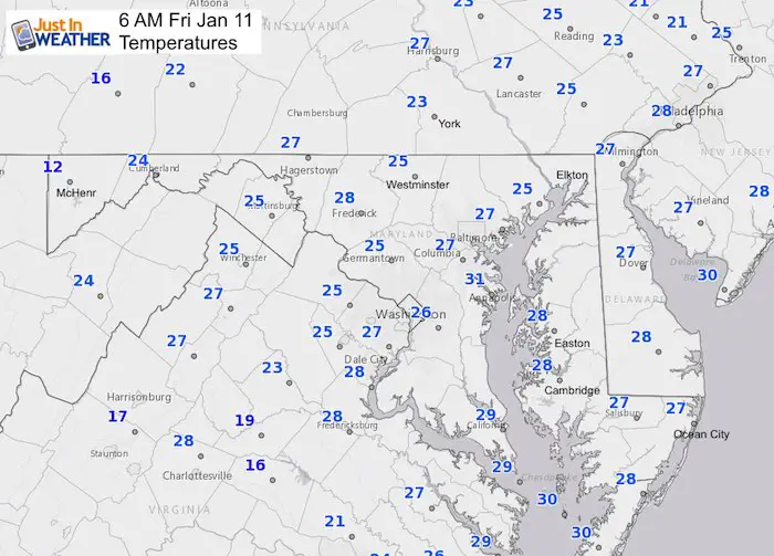
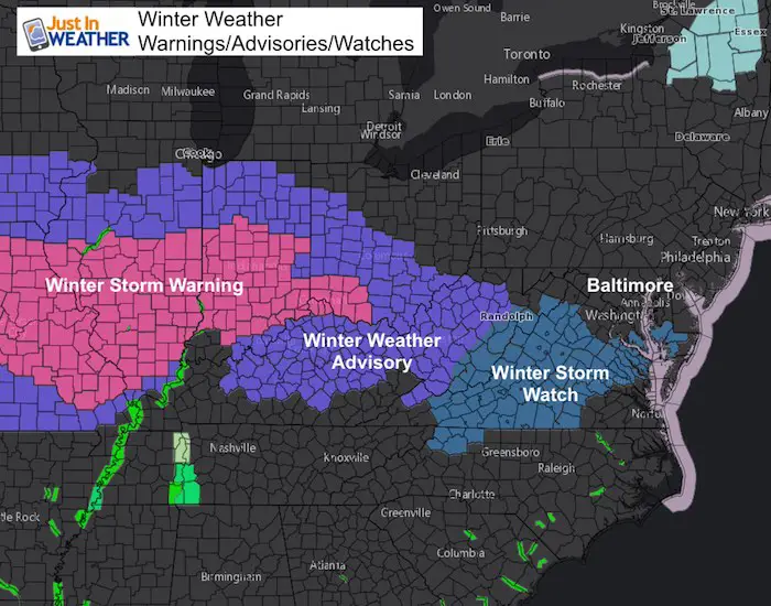
The cold air is in place and winds will still be a factor today. This has all helped to chill the ground, so when snow does arrive this weekend it will stick. A Winter Storm Watch has been issued for our southern areas where more may fall, but I expect advisories to include metro areas and southern PA when issued later. Since the snow is expected to arrive later Saturday, the advisories will be issued later today.
The latest idea of how the storm will play it still banks on the initial snow Saturday afternoon and evening. There will be an impact on travel Saturday night, so those plans might need to be addressed. Sunday morning plans may also need to be considered with slick roads. The second part of this event on Sunday is the big question, and might have trouble fully materializing. Light snow and showers on Sunday are likely but may be after most of the accumulation. Slick roads could extend into Monday morning.
The Saturday snow timeline and my call for snowfall map is posted below.
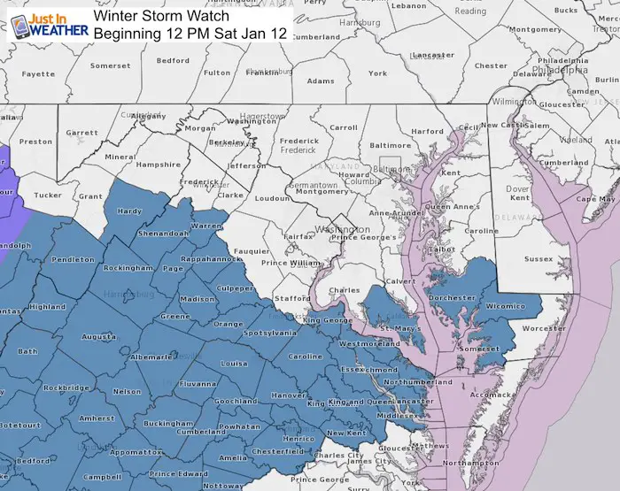
Winter Storm Watch
The first round of Winter Storm Watches has been posted and includes southern Maryland. I want to point out that this follows where snow may be heavier. By this evening, I expect Winter Weather Advisories to be issued into central Maryland and maybe southern PA.
Quick Storm Planning
- Light snow develops Saturday mid afternoon to evening.
- Moderate snow Saturday night. Most accumulation by Sunday morning
- Sunday: Early snow then flurries or snow showers. Travel may be OK afternoon IF the storm does not develop, but Southern areas are at most risk. Still check to see if snow expands north.
- Monday morning: The storm will be done, but some slick roads or sidewalks where not treated.
Local Weather Stats For January 11, 2019 in Baltimore
Average High: 41ºF
Record High: 73ºF in 1975
Average Low: 24ºF
Record Low: 1ºF in 1982
*Record Snow: 3.8″ in 1954
Sunrise: 7:25 AM
Sunset 5:03 PM
*Daylight = 1:13 longer than yesterday
*Bay Water Temperature = 41ºF at Thomas Pt. Light House
Keep In Touch Every Day
Just in case you don’t get all posts on your social media feed, stay up to date with the latest info…
Click here to sign up for email alerts…. Be the first to hear any new weather forecasts
This Morning
Temperatures
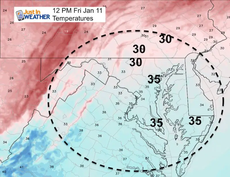
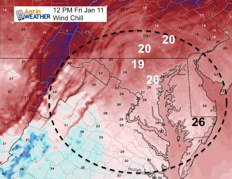
| Noon Temperatures | Noon Wind Chills |
 |
 |
Storm Set Up
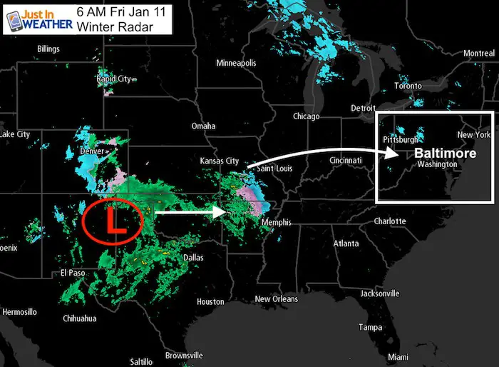
Morning Radar
Watches And Warnings
Snow Timeline –> slider
[metaslider id=70522]
Storm Animation
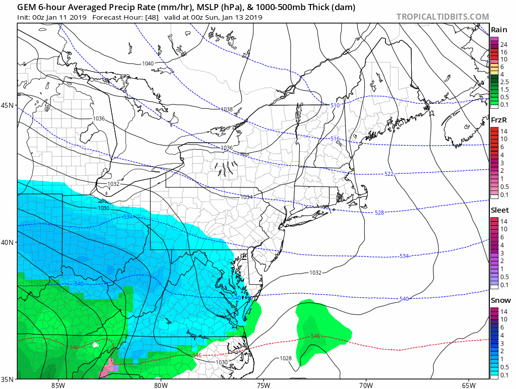
The Canadian Model does show light snow or snow showers into mid day or afternoon Sunday. Notice the system being suppressed to the south. This has been the question all along. Either arctic High Pressure pushes it there or the storm develops sooner and holds north. coastal areas will have rain, but end with snow
How Much Snow?
Computer Model Spread (3 Models To Compare)
NAM 3 Km (the model shown in the slider)

European Model

Canadian GEM Model

My Call For Snowfall

A: 6 to 8 inches in the mountains
B: 3 to 6 inches Southern VA to southern MD. This range is due to any mixing or rain early, but more snow later. Coastal Areas will get rain, but end with a burst of snow. I included them in this zone with the chance to catch up at the finish.
C: 2 to 4 inches. Metro Washington, Annapolis, Baltimore, to York PA
D: Dusting to 2 inches. These areas will be on the northern edge and dry air form the arctic high needs to be considered eroding away what falls.
Quick Storm Planning
- Light snow develops Saturday mid afternoon to evening.
- Moderate snow Saturday night. Most accumulation by Sunday morning
- Sunday: Early snow then flurries or snow showers. Travel may be OK afternoon IF the storm does not develop, but Southern areas are at most risk. Still check to see if snow expands north.
- Monday morning: The storm will be done, but some slick roads or sidewalks where not treated.
Snow Day Kit
NEW: Individual Items Are Now Available A La Carte.

Our ritual the night before a storm is finally in one kit. Maybe if more Maryland kids had this, the storm would reach us 🙂
- This includes a very soft raglan Tee printed inside out with #FITF AND the check list, #FITF spoon for under your pillow, ice cube tray with snowflake shapes, chalk, a #FITF wrist-band, a mini SnowStix, and a bag to carry it all in.
- This will also help us give a free Snow Day Kit to each of the Just In Power Kids.
New Partner
I’d like to welcome Buchanan Kia of Westminster: Now a supporter of Just In Power Kids and Maryland Trek 6 in August 2019. Soon we will be showing you why we developed this relationship with a local business that my wife and I sincerely trust.

FITF and SnowStix Available NOW

Keep In Touch Every Day
Just in case you don’t get all posts on your social media feed, stay up to date with the latest info…
Click here to sign up for email alerts…. Be the first to hear any new weather forecasts
Please share your thoughts, best weather pics/video, or just keep in touch via social media
-
Facebook: Justin Berk, Meteorologist
-
Twitter: @JustinWeather
-
Instagram: justinweather
Keep In Touch Every Day
Click here to sign up for email alerts…. Just in case you don’t get the post on your social media feed
Related Links:
Winter Outlook
My Winter Outlook 2018-19: Multiple Nor’Easters and more snow

Interactive Snow Report
November 15 Snow Reports- Interactive Map Compared To My Forecast

Winter Snow And Top 5 Wet Years
Snowfall Seasons at Beginning and End of Top 5 Wet Years In Baltimore

Related Winter Outlooks
Solar Cycle: When Sun Spots Are Low We Get More Snow
El Nino Modoki May Enhance Snow Chances
Sweet Spot: Hitting 70ºF on Halloween is followed by more winter snow
Will A Wet Summer Bring A Snowy Winter?
NOAA Winter 2018-2019 Outlook Explained: This Actually Supports Snow
Winter Outlook From Two Different Farmers Almanacs
Maryland Winters: Snowfall Maps and Baltimore Snow History
