Wednesday January 9 2019
If you live on the north side of Baltimore, then you may have seen the snow or graupel showers today. The radar has indicated that this was changing to rain around Baltimore and the rest of central Maryland, but you might have had some lucky flakes survive. Nothing is sticking for any road issues. But there will be one more wave of snow in a band that is part of the arctic air. When it arrives, you will feel it for sure.
Reminder:
Just in case you don’t get all posts on your social media feed, stay up to date with the latest info…
Click here to sign up for email alerts…. Be the first to hear any new weather forecasts
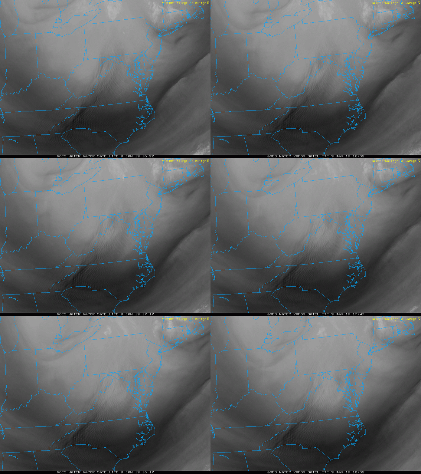
Here is a look at the afternoon satellite showing the flow of cold air with plenty of clouds off of the Great Lakes.
Satellite Loop
Notice the ripples in PA, MD, and VA. That is a result of the instability as cold air flows up and down the mountains.
The dark line moving south form Lake Erie is the surge of arctic air to ignite the last snow band and our big cool down.
Radar at 2 PM
Snow = blue; Rain = Green

Radar Simulation —> slider
The initialization was pretty good compared to the 2 PM simulation below. Note this was generated a few hours earlier, so its good to compare to make sure the model is identifying everything properly.
[metaslider id=70426]
This will mark the arctic air moving in this evening and tonight.
Evening Temperatures

Evening Wind Chills

FITF and SnowStix Stores are now OPEN
Morning Temperatures

Morning Wind Chill

Note: Winds will be between 20 and 35 mph most of Thursday. Wind chills likely to stay in the teens and 20s all day
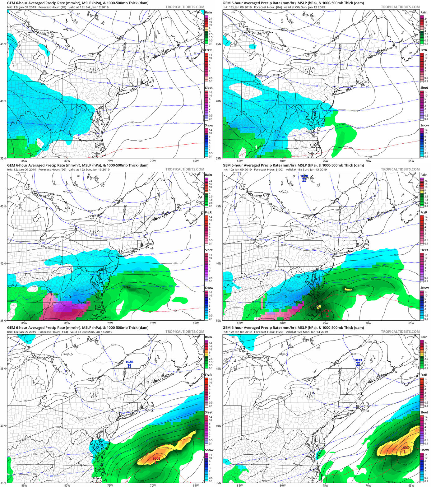
Peek at the Weekend Snow:
This event is still looking promising for late Saturday into Sunday. I will have more details in my evening report.
Canadian GEM Starting Saturday 1 PM
‘d like to welcome Buchanan Kia of Westminster: Now a supporter of Just In Power Kids and Maryland Trek 6 in August 2019. Soon we will be showing you why we developed this relationship with a local business that my wife and I sincerely trust.
Snow Day Kit
Our ritual the night before a storm is finally in one kit. Maybe if more Maryland kids had this, the storm would reach us 🙂
- This includes a very soft raglan Tee printed inside out with #FITF AND the check list, #FITF spoon for under your pillow, ice cube tray with snowflake shapes, chalk, a #FITF wrist-band, a mini SnowStix, and a bag to carry it all in.
- The introduction special price will end tonight.
- This will also help us give a free Snow Day Kit to each of the Just In Power Kids.
Keep In Touch Every Day
Click here to sign up for email alerts…. Be the first to hear the big news over the weekend
Also- Just in case you don’t get the post on your social media feed
Please share your thoughts, best weather pics/video, or just keep in touch via social media
-
Facebook: Justin Berk, Meteorologist
-
Twitter: @JustinWeather
-
Instagram: justinweather
Keep In Touch Every Day
Click here to sign up for email alerts…. Just in case you don’t get the post on your social media feed
Related Links:
Winter Outlook
My Winter Outlook 2018-19: Multiple Nor’Easters and more snow
Interactive Snow Report
November 15 Snow Reports- Interactive Map Compared To My Forecast
Winter Snow And Top 5 Wet Years
Snowfall Seasons at Beginning and End of Top 5 Wet Years In Baltimore
Related Winter Outlooks
Solar Cycle: When Sun Spots Are Low We Get More Snow
El Nino Modoki May Enhance Snow Chances
Sweet Spot: Hitting 70ºF on Halloween is followed by more winter snow
Will A Wet Summer Bring A Snowy Winter?
NOAA Winter 2018-2019 Outlook Explained: This Actually Supports Snow
Winter Outlook From Two Different Farmers Almanacs
Maryland Winters: Snowfall Maps and Baltimore Snow History
Snowstix- We Need You To Measure Snow Too
We are giving 10% of each sale to Just In Power Kids: Providing FREE holistic care for pediatric oncology patients.


