Thursday December 13 2018
It’s been a while since we had rain. The headline here could be that Baltimore has not had measurable rain in 11 days, since December 2. But that is about change and go figure it would happen on a Friday into the weekend. This brings us back to the old Fall pattern that includes heavy rain. As a result, NWS has issued a Flood Watch for all of central Maryland and into eastern Virginia.

Added To The Record
The expectation of over 2 inches of rain will increase our already record wet year.

Rain Forecast: What To Expect
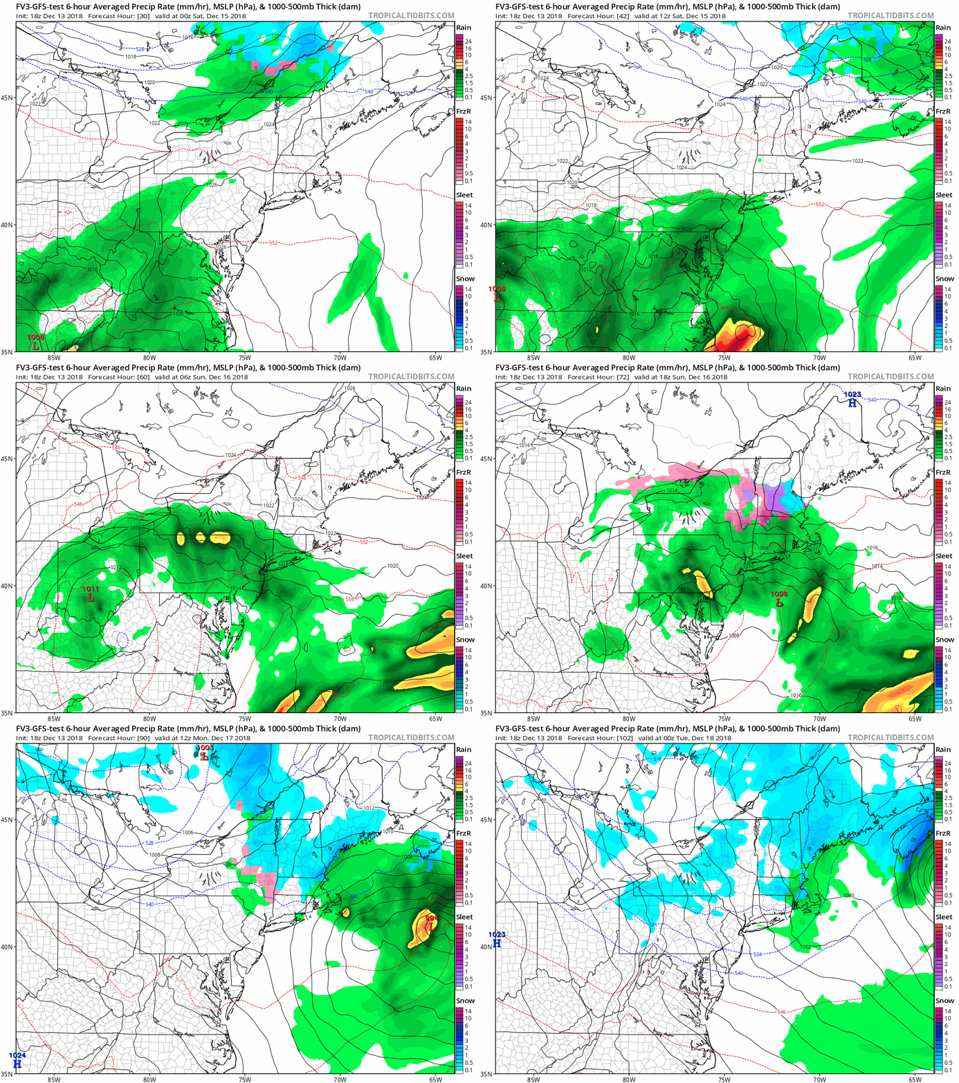
Rain will expand from south to north Friday afternoon and evening. It may be at its heaviest during the day Saturday. Thanks to an upper level system, this storm will linger into Sunday only to be followed by colder air Monday (which I still think may bring snow showers to parts of our area). The net result could bring between 1 and 3 inches of rain to the area.
Here is a look at two models run expectations.
The European ECMWF has
- 1.5″ to 2″ range in Baltimore and central Maryland
- 1.1″ in York PA
- 1.3″ to 1.6″ across southern Maryland to Ocean City

The NAM 3 Km Model is much more aggressive:
- 2.7″+ in Baltimore and central Maryland
- 1.4″ in York PA
- 2″ to 3.1″ Maryland to Ocean City

Rain Timeline–> sliders
Here is the NAM break down
Friday:
Arrival mid afternoon making a wet evening
[metaslider id=69581]
Saturday:
- Moderate to heavy rain at any point in the day.
- This is the most likely time to have flooding. We could have some claps of thunder.
[metaslider id=69598]
Sunday: Showers will linger under the upper low as shown in the animation below.
Storm Animation
FV3 GFS
Is This A Hint For Snow?
On the bright side, if you anxious for winter weather… we might have some thunder. The old Weather Folklore saying supports: “If in winter you hear thunder, snow will follow in a week or under”.
FITF and SnowStix Stores are now OPEN
Keep In Touch Every Day
Click here to sign up for email alerts…. Be the first to hear the big news over the weekend
Also- Just in case you don’t get the post on your social media feed
Please share your thoughts, best weather pics/video, or just keep in touch via social media
-
Facebook: Justin Berk, Meteorologist
-
Twitter: @JustinWeather
-
Instagram: justinweather
Keep In Touch Every Day
Click here to sign up for email alerts…. Just in case you don’t get the post on your social media feed
Related Links:
Winter Outlook
My Winter Outlook 2018-19: Multiple Nor’Easters and more snow
Interactive Snow Report
November 15 Snow Reports- Interactive Map Compared To My Forecast
Winter Snow And Top 5 Wet Years
Snowfall Seasons at Beginning and End of Top 5 Wet Years In Baltimore
Related Winter Outlooks
Solar Cycle: When Sun Spots Are Low We Get More Snow
El Nino Modoki May Enhance Snow Chances
Sweet Spot: Hitting 70ºF on Halloween is followed by more winter snow
Will A Wet Summer Bring A Snowy Winter?
NOAA Winter 2018-2019 Outlook Explained: This Actually Supports Snow
Winter Outlook From Two Different Farmers Almanacs
Maryland Winters: Snowfall Maps and Baltimore Snow History
Snowstix- We Need You To Measure Snow Too
We are giving 10% of each sale to Just In Power Kids: Providing FREE holistic care for pediatric oncology patients.


