Thursday December 13 2018
Just a few days ago it looked like we may have some snow showers this morning. That has fallen under the some trend as that last storm and shifted to the north. No worries locally this morning, but snow is pushing through northern PA and central New York as warmer air is moving in for us. Then we shift our focus to rain form the south that will reach us Friday afternoon and could be heavy by at night and Saturday morning. This will add to our record wet year, only to be followed by colder air after it passes.

If you are holding out for snow, we will have some Lake Effect showers try to reach us on Monday. Beyond that the long range pattern looks more promising Christmas week.
Local Weather Stats For December 13 in Baltimore
Average High: 46ºF
Record High: 72ºF in 2015
Average Low: 29ºF
Record Low: 8ºF in 1960
*Record Snow: 7.6″ in 1966
Sunrise: 7:17 AM
Sunset 4:43 PM
*Daylight = 0:33 shorter than yesterday
*Bay Water Temperature = 40ºF at Thomas Pt. Light House
Morning Temperatures

Afternoon High Temperatures
Mid 40s to near 50ºF will feel warm

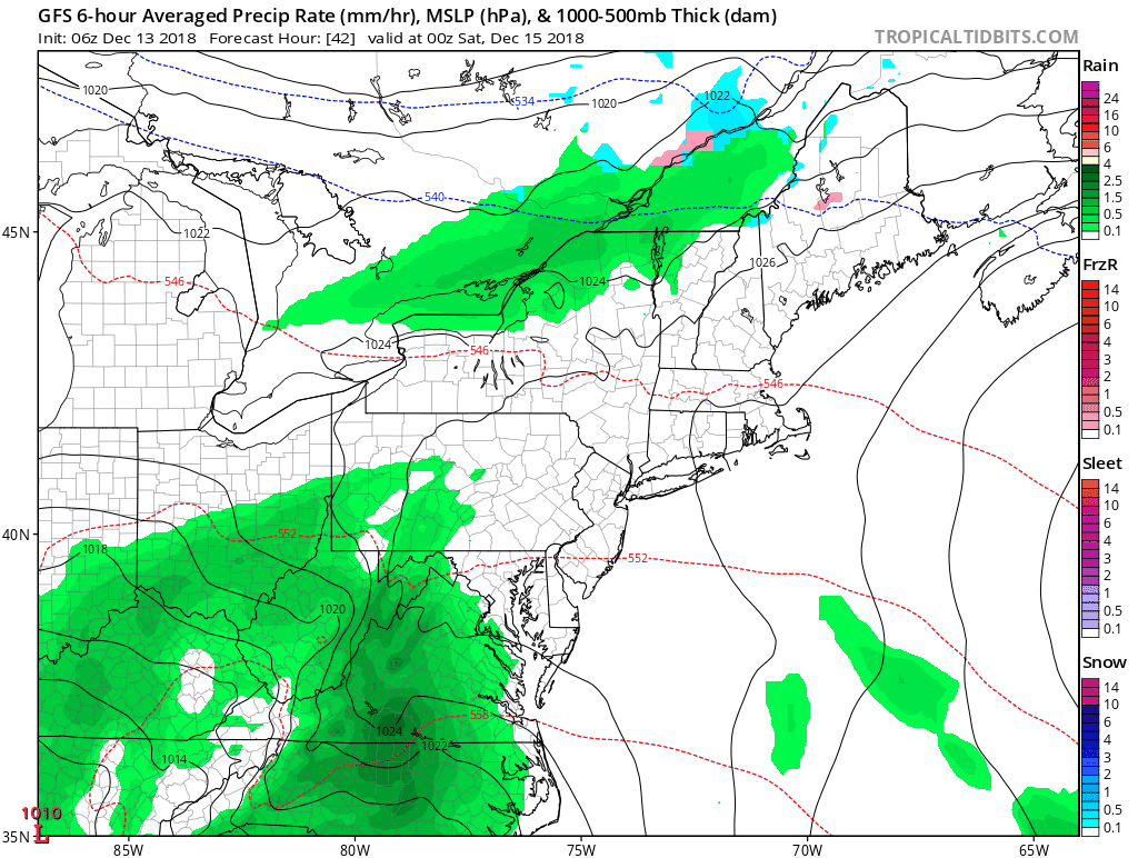
Rain Friday —> slider
This will arrive during the afternoon and could be heavy at night
[metaslider id=69543]
Heavier Rain Saturday Morning

Rain Totals – By Mid Day Saturday
Baltimore forecast of 1.3″ to over 2 inches in Southern Maryland.

Storm Animation
- Rain will move in Friday afternoon and evening.
- Rain will linger Saturday afternoon and more showers Sunday
- Monday- Turning Colder with snow showers to our north
Monday Snow Showers?

The GFS Model does cut the snow back to the mountains, but there is a lot of upper air support to carry them into central Maryland.

Long Range Outlook
The next batch of cold air to hold in place may be Christmas Week. I do not look at specific numbers that far out. The trend turning colder and below average is the important take away… It will be colder for the holiday week.

Snow Day Kit
Our ritual the night before a storm is finally in one kit. Maybe if more Maryland kids had this, the storm would reach us 🙂
- This includes a very soft raglan Tee printed inside out with #FITF AND the check list, #FITF spoon for under your pillow, ice cube tray with snowflake shapes, chalk, a #FITF wrist-band, a mini SnowStix, and a bag to carry it all in.
- Order by December 14 and it should arrive for the holiday.
- This will also help us give a free Snow Day Kit to each of the Just In Power Kids.

FITF and SnowStix Stores are now OPEN

Keep In Touch Every Day
Click here to sign up for email alerts…. Be the first to hear the big news over the weekend
Also- Just in case you don’t get the post on your social media feed
Please share your thoughts, best weather pics/video, or just keep in touch via social media
-
Facebook: Justin Berk, Meteorologist
-
Twitter: @JustinWeather
-
Instagram: justinweather
Keep In Touch Every Day
Click here to sign up for email alerts…. Just in case you don’t get the post on your social media feed
Related Links:
Winter Outlook
My Winter Outlook 2018-19: Multiple Nor’Easters and more snow

Interactive Snow Report
November 15 Snow Reports- Interactive Map Compared To My Forecast

Winter Snow And Top 5 Wet Years
Snowfall Seasons at Beginning and End of Top 5 Wet Years In Baltimore

Related Winter Outlooks
Solar Cycle: When Sun Spots Are Low We Get More Snow
El Nino Modoki May Enhance Snow Chances
Sweet Spot: Hitting 70ºF on Halloween is followed by more winter snow
Will A Wet Summer Bring A Snowy Winter?
NOAA Winter 2018-2019 Outlook Explained: This Actually Supports Snow
Winter Outlook From Two Different Farmers Almanacs
Maryland Winters: Snowfall Maps and Baltimore Snow History

Snowstix- We Need You To Measure Snow Too
We are giving 10% of each sale to Just In Power Kids: Providing FREE holistic care for pediatric oncology patients.
