 Wednesday November 28 2018
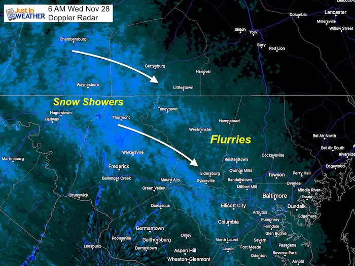
I woke up this morning expecting the wind to be the main story, but saw the radar lit up with snow. The upper level energy has allowed some snow showers to cross the mountains. I check the road cameras from Hagerstown to Mount Airy and Thurmont and they appear to be OK. But flakes will be flying in the form of flurries or snow showers this morning. The may reach Baltimore, but more likely on the west and north side.
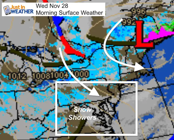
The storm responsible for this is located in Maine. It has a tight pressure gradient that will make the winds stronger today than yesterday. The snow showers are not our big story, even if you have FITF. It will be strong winds.
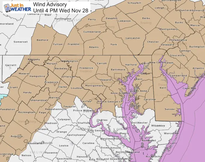
Wind Advisory
- The winds will be gusting over 40 mph today. This will impact much of our are with the following risks:
- Restrictions on area bridges
- Tree branches, decorations, garbage cans flying down the street.
- Downed Trees: Our record rainfall and soggy ground may lead to some trees tipping over.
More details below.
Local Weather Stats For November 28 in Baltimore
Average High: 51ºF
Record High: 73ºF in 1990
Average Low: 33ºF
Record Low: 15ºF in 1951
*Record Snow: 1.7″ in 1917
Sunrise: 7:04 AM
Sunset 4:44 PM
*Daylight = 1:23 shorter than yesterday
*Bay Water Temperature = 47ºF at Thomas Pt. Light House
Record Rain Year Update:
The rain on Monday was 0.42″ at BWI. Considering the storm on the way this weekend and one month left in 2018, we may make a run for 70 inches.

Morning Snapshot


Peak Wind Gusts
The noodle shows areas over 40 mph, but I think we will get gusts to 50 mph in our area. That is enough to topple some trees.

Afternoon


Outlook
Weekend Rain
It looks like showers arrive Friday, the steady rain will building Saturday afternoon and night.
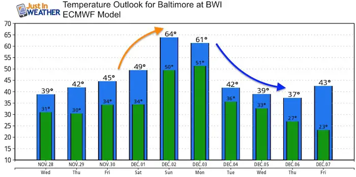
Temperatures
The warm up will come after the rain this weekend… But we will get some dry hours to enjoy it outside. Then we get our return to winter next week.
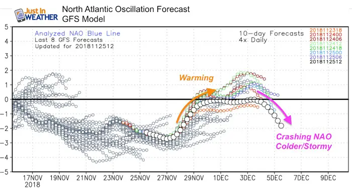
North Atlantic Oscillation
The rising index to near zero will be with our warming trend at the end of The Weeknd. The crashing negative index will be associated with our pattern change and return to winter. This will set us up for multiple storms with cold air. Not all will translate to snow, but we will have our best chances AFTER Dec 5.
Keep In Touch Every Day
Click here to sign up for email alerts…. Be the first to hear the big news over the weekend
Also- Just in case you don’t get the post on your social media feed
Please share your thoughts, best weather pics/video, or just keep in touch via social media
-
Facebook: Justin Berk, Meteorologist
-
Twitter: @JustinWeather
-
Instagram: justinweather
Keep In Touch Every Day
Click here to sign up for email alerts…. Just in case you don’t get the post on your social media feed
Related Links:
Winter Outlook
My Winter Outlook 2018-19: Multiple Nor’Easters and more snow

Interactive Snow Report
November 15 Snow Reports- Interactive Map Compared To My Forecast

Winter Snow And Top 5 Wet Years
Snowfall Seasons at Beginning and End of Top 5 Wet Years In Baltimore

Related Winter Outlooks
Solar Cycle: When Sun Spots Are Low We Get More Snow
El Nino Modoki May Enhance Snow Chances
Sweet Spot: Hitting 70ºF on Halloween is followed by more winter snow
Will A Wet Summer Bring A Snowy Winter?
NOAA Winter 2018-2019 Outlook Explained: This Actually Supports Snow
Winter Outlook From Two Different Farmers Almanacs
Maryland Winters: Snowfall Maps and Baltimore Snow History

FITF and SnowStix Stores are now OPEN

Snowstix- We Need You To Measure Snow Too
We are giving 10% of each sale to Just In Power Kids: Providing FREE holistic care for pediatric oncology patients.
