Wednesday September 26 2018 12 PM
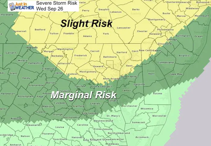
Earlier today my morning forecast included a Slight Risk for Severe Storms in central Maryland and much of Pennsylvania later toady. Heat and humidity today makes it feel like summer as a fall cold front collides and slides through. This will develop storms during the afternoon and into the evening. Here is a look at the visible satellite loop showing the cloud line building while the sun has pushed up temps in the metro areas. Baltimore may be front and center for the storms this evening.
Visible Satellite Loop 2 Hours Through Noon

Noon Set Up
My focus here is on wind direction! When there is a southeast wind off of the Bay, there is often a higher chance to enhance storms that arrive from the mountains. Today, we see a regional flow form the south-southwest, but a distinct Chesapeake Bay Breeze from the southeast. I’ve highlighted the contrast and convergence zone in the hashed yellow box.
The extent of the convergence will determine where storms enhance and possibly even slow down their movement. This is actually reflected in slider timeline below showing up between Westminster and Mt. Airy as the line moves east.

The radar timeline slider here for the High Resolution Rapid Refresh Model (HRRR) has done a good job pointing out strong cells and the timeline within 1 hour cushion lately. Stating between 5 PM and midnight is a broad brush for our region. It looks like storms will develop later this afternoon in the mountains and then move near York, Westminster, and Mt. Airy around 7 PM. Two pulses on the line will pass through, but the southern edge near Baltimore and Annapolis might stall after 8 PM. Here is a look showing the most likely set up and time frame:
Radar Simulation—> slider
The one thing that may limit the severity could be the timing. The sun sets before 7 PM, so storms hitting after that will work mostly on the front and less form diurnal heating.
[metaslider id=66214]
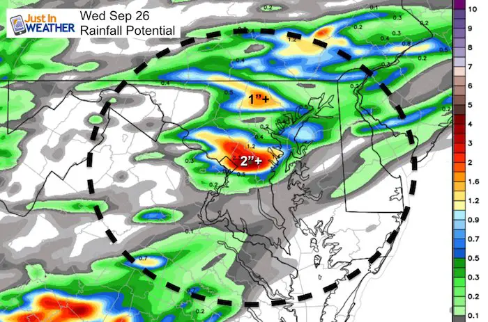
Potential Rain
The heaviest spots will be between 1″ to 3″, but some on the edge could get less than 0.25″.
This is contingent on the track of individual cells and if the front or cells slow down/stall along I-70 between Howard, PG, Anne Arundel Countiesand Baltimore City
Severe Storm Risk
Severe Storms by definition include:
- Wind gusts over 58 mph
- Large Hail over 1″ diameter
- Potential Flash Flooding
- Isolated tornadoes possible
Coastal Flood Advisory
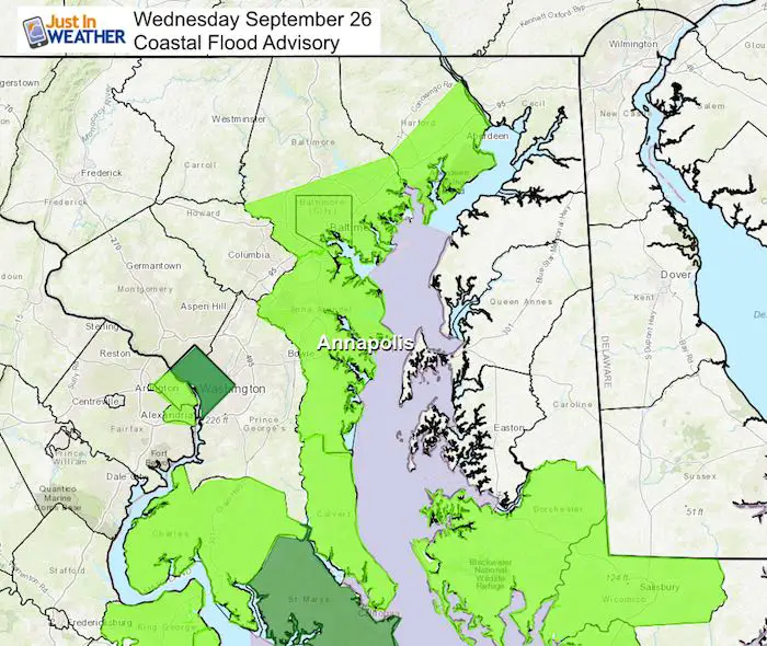
We are still on for more rain Thursday and then clearing this weekend. I will post another storm track update later this afternoon.
Keep In Touch Every Day
Click here to sign up for email alerts…. Just in case you don’t get the post on your social media feed
Please share your thoughts, best weather pics/video, or just keep in touch via social media
-
Facebook: Justin Berk, Meteorologist
-
Twitter: @JustinWeather
-
Instagram: justinweather
Love Maryland Shirt Designed By Jaiden
 |
|
This shirt was designed by my ‘bonus’ daughter Jaiden. All proceeds will go to Just In Power Kids and free holistic therapy for kids in and post cancer treatment.
Show your love for Maryland and make this 14 year old artist extra proud
|
![]()
 Get the award winning Kid Weather App I made with my oldest son and support our love for science, weather, and technology. Our 3 year anniversary of the release and our contribution to STEM education is this November. It has been downloaded in 60 countries, and works in both temperature scales. With your support we can expand on the fun introduction to science and real weather.