 Wednesday September 26 2018
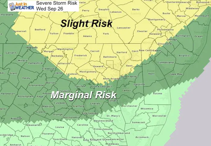
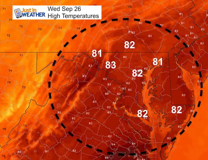
Today starts warm and humid with some areas of fog and mist. Temps will warm into the mid 80s and remain muggy so it might feel like the 90s. All of that is full ahead of a cold front to produce strong and severe storms. The timing will be late afternoon and evening. A small chance of storms will reach severe levels which includes winds over 58 mph and large hail over 1″ diameter. This can produce tree and property damage.
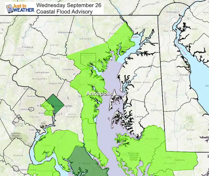
Flooding is another issue: Storm potential will bring between 1 and 3 inches of rain in the heaviest downpours. But there is still a coastal flood advisory along the shores of the Chesapeake Bay. Annapolis is among the places that have been dealing with the for a few weeks.
We still have another day with rain tomorrow. But our weekend outlook still looks a lot better and much more like autumn. Here is a quick look:
Note:
*If you saw this link on Facebook or Twitter…. After reading this, go back and just make a simple comment like, “Please update me again later”. I will post the next update there and you should get the notification.
Local Weather Stats For September 26 in Baltimore
Average High: 74ºF
Record High: 95ºF in 1970
Average Low: 53ºF
Record Low: 35ºF in 1963 *Coldest for the month
Sunrise: 6:57 AM
Sunset 6:56 PM
*Daylight = 2:33 shorter than yesterday
*Bay Water Temperature = 72ºF at Thomas Pt. Light House
Also see:
Winter Outlook From Two Different Farmers Almanacs
Now Scheduling School Assemblies
- Storm Smart – Severe Weather (September, October; March through May)
- FITF – Snow and ice (November through March)
Programs for K through Middle School
Choose flat fee or FREE along with a spirit wear shirt fundraiser that earns your school money.
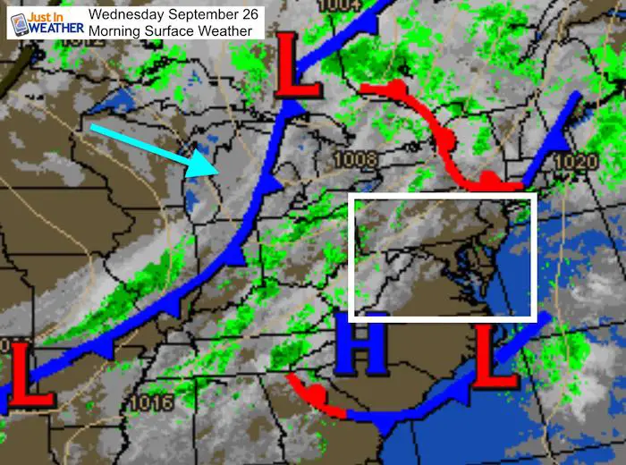
Morning Set Up
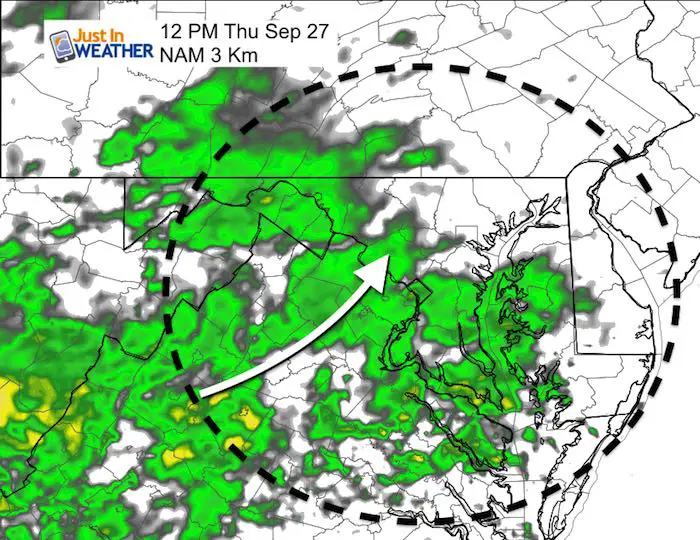
That cold front will arrive by this evening, but stall to our south and return Thursday with more rain
Coastal Flood Advisory
The push of easterly winds and high water sloshing on the Bay keeps the flooding in places like Annapolis and along the western and southern shores of the Chesapeake Bay
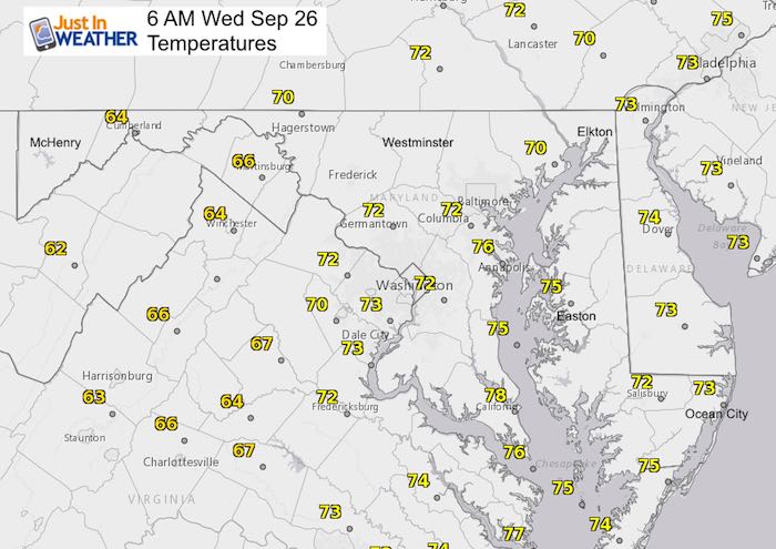
Morning Temperatures
Afternoon High Temperatures
Radar Simulaiton –> slider
Storm potential will bring between 1 and 3 inches of rain in the heaviest downpours.
[metaslider id=66190]
Severe Outlook Again
More Rain Thursday
The front stars to our south and moves back north with rain by lunch tine… lasting all afternoon again.
Rain Animation

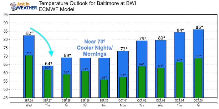
Temperature Outlook
While it is muggy today, it will definitely feel like autumn this weekend. Check out the low temps in the 50s bay Baltimore. Maybe some 40s in the colder suburbs
Help Me Test This:
*If you saw this link on Facebook or Twitter…. After reading this, go back and just make a simple comment like, “Please update me again later”. I will post the next update there and you should get the notification.
Keep In Touch Every Day
Click here to sign up for email alerts…. Just in case you don’t get the post on your social media feed
Please share your thoughts, best weather pics/video, or just keep in touch via social media
-
Facebook: Justin Berk, Meteorologist
-
Twitter: @JustinWeather
-
Instagram: justinweather
Love Maryland Shirt Designed By Jaiden
 |
|
This shirt was designed by my ‘bonus’ daughter Jaiden. All proceeds will go to Just In Power Kids and free holistic therapy for kids in and post cancer treatment.
Show your love for Maryland and make this 14 year old artist extra proud
|
![]()
 Get the award winning Kid Weather App I made with my oldest son and support our love for science, weather, and technology. Our 3 year anniversary of the release and our contribution to STEM education is this November. It has been downloaded in 60 countries, and works in both temperature scales. With your support we can expand on the fun introduction to science and real weather.