Wednesday September 5 2018
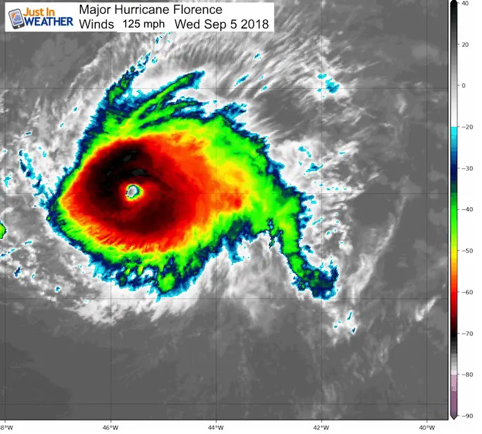
Hurricane Florence ha become the first major hurricane of the season for the Atlantic basin. Winds in the latest report have clocked 125 mph, making a Category 3 on the Saffir-Simpson Scale. It looks very impressive on the satellite loop shown below, but hurricane force winds only extend 15 miles from the center. As of now, it is a small storm. Florence as this has broken through many barriers this season including Saharan dust, wind sheer, and cooler water. The environment now supports this storm with warmer water and upper level steering to bring it towards the US next week.
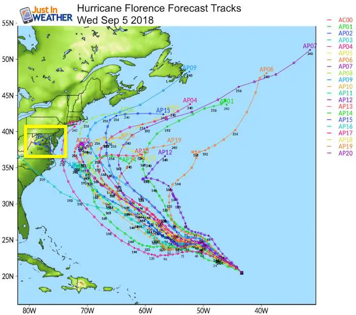
Under normal conditions I would suggest this storm would curve away and stay in the open ocean. But the pattern suggests this storm might miss getting picked up and allow it to continue to the west for then next week. That would take it past Bermuda and off of the North Carolina Coast by next Friday. That is a lot of time to watch and plenty of room for adjustment. But, given the humid onshore flow we have had much of this summer, it is worth the concern.
NHC Forecast Track
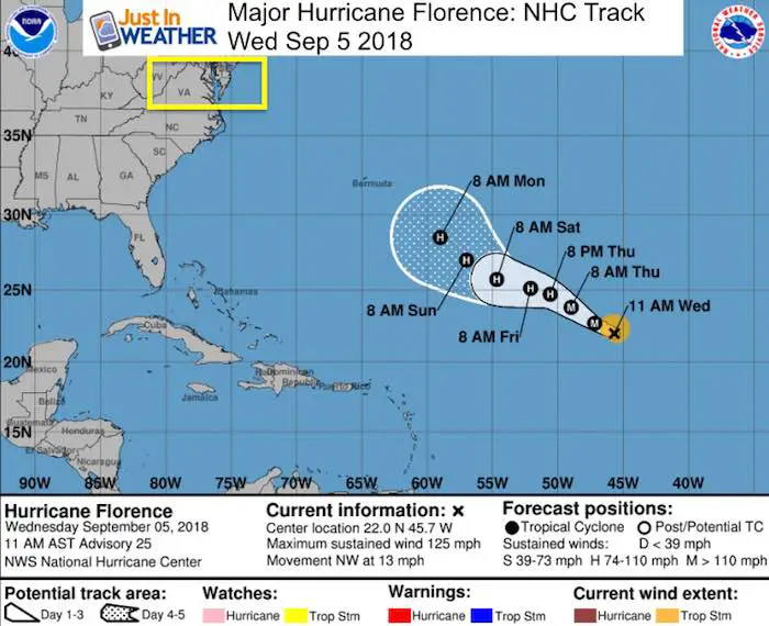
11 AM AST Stats on Hurricane Florence
LOCATION...22.0N 45.7W
ABOUT 1160 MI...1865 KM ENE OF THE NORTHERN LEEWARD ISLANDS
ABOUT 1370 MI...  ESE OF BERMUDA
MAXIMUM SUSTAINED WINDS...125 MPH...205 KM/H
PRESENT MOVEMENT...NW OR 305 DEGREES AT 13 MPH...20 KM/H
MINIMUM CENTRAL PRESSURE...957 MB...28.26 INCHES
Satellite Loop

Computer Model Forecast Tracks
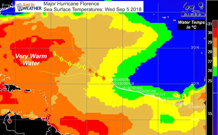
Warm Water
Sea Surface Temperatures given in ºC show the path of Hurricane Florence will be entering a zone that will provide more fuel to keep the storm strong.
Next Week?
This is the GFS Model that has had a lot of money invested into upgrading. This may be a true test for long range viability as it plots this storm off of the North Carolina coast as the end of next week. It is shown to stall and then drift north, with a possible impact on New England. That is worth watching to see if it holds or evolves differently over the next week. There is plenty of time to plan.
This is also worth watching for potential impact on the invisible stamp of Atmospheric Memory. There is a weakness off of the east coast already that will likely try to repeat itself in autumn and winter.

Potential to hug the east coast
Note the image here is for NEXT Friday, 228 hour forecast. A lot can change but this will be a reference point to plot any adjustments or trends.

Now Scheduling School Assemblies
- Storm Smart – Severe Weather (September, October; March through May)
- FITF – Snow and ice (November through March)
Programs for K through Middle School
Choose flat fee or FREE along with a spirit wear shirt fundraiser that earns your school money.
 Get the award winning Kid Weather App I made with my oldest son and support our love for science, weather, and technology. Our 3 year anniversary of the release and our contribution to STEM education is this November. It has been downloaded in 60 countries, and works in both temperature scales. With your support we can expand on the fun introduction to science and real weather.
Please share your thoughts, best weather pics/video, or just keep in touch via social media
-
Facebook: Justin Berk, Meteorologist
-
Twitter: @JustinWeather
-
Instagram: justinweather
Keep In Touch Every Day
Click here to sign up for email alerts…. Just in case you don’t get the post on your social media feed
Power Partner in Maryland Trek 5 For Just In Power Kids:

Support Just In Power Kids
We are still taking donations for our best Maryland Trek yet. Every penny goes to Just In Power Kids programs to provide FREE holistic care for kids in cancer treatment and up to 5 years post treatment.
![]()