 Tuesday September 4 2018
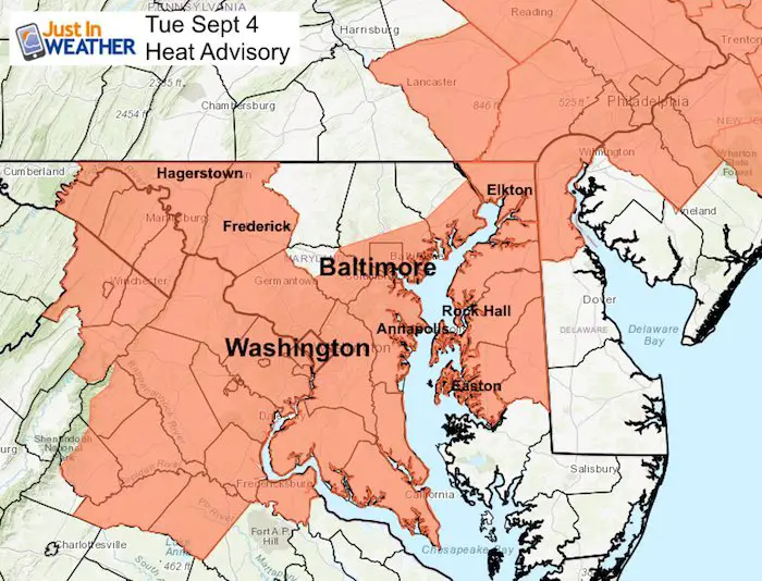
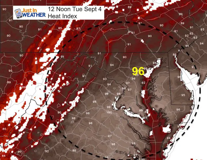
A Heat Advisory today signals how uncomfortable the weather will feel today. Temperatures are already warm and sticky this morning, but by mid day and this afternoon temperatures will be running 10 degrees above ‘normal’ and will feel like 100ºF. Baltimore County has decided to keep 10 schools closed due to their lack of air conditioning. However, Baltimore City is holding school but closing 3 hours early.
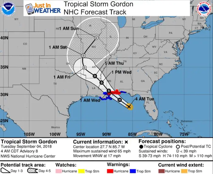
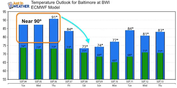
This weather will continue through Thursday, then get some relief Friday and into the weekend. However then we watch a stalling cold front combine with moisture from Tropical Storm Gordon to keep us wet for a few days.
Local Weather Stats For September 4 in Baltimore
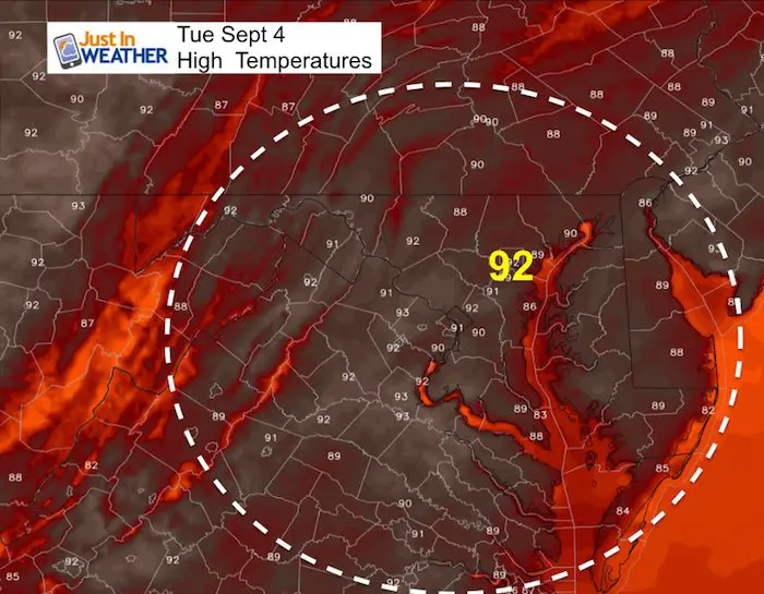
Average High: 82ºF
Record High: 96ºF in 1937
Average Low: 62ºF
Record Low: 50ºF in 1997
Sunrise: 6:37 AM
Sunset 7:32 PM
*Daylight = 2:29 shorter than yesterday
*Bay Water Temperature = 84ºF at Thomas Pt. Light House
Also see: Winter Outlook From Two Different Farmers Almanacs
Morning Snapshot
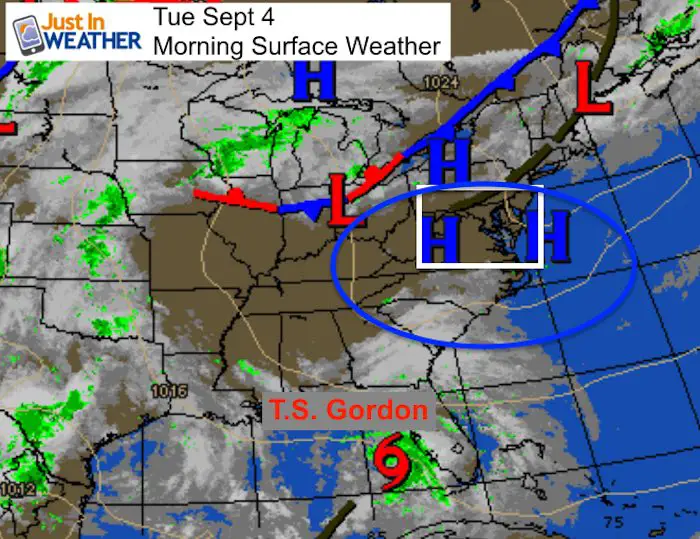
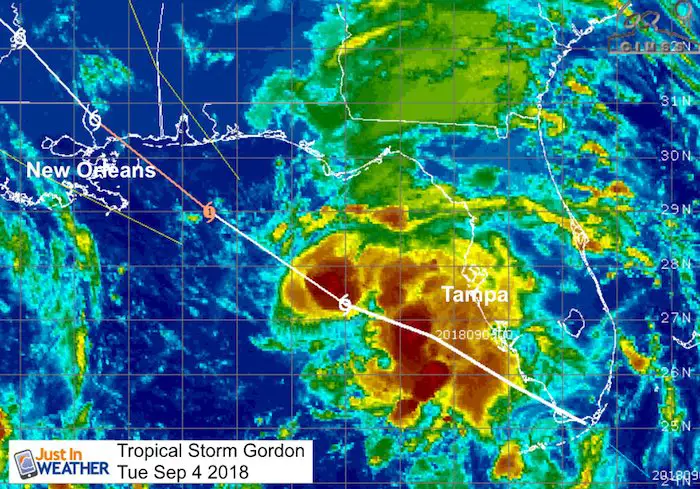
High Pressure is in control and responsible for our heat and humidity. Storms will be isolated this afternoon, but this is directing Tropical Storm Gordon away from us, but into the Gulf Coast near New Orleans.
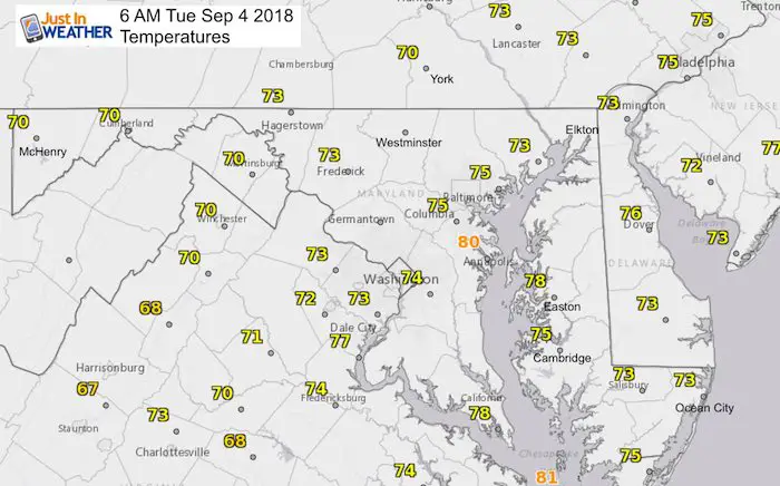
Temperatures
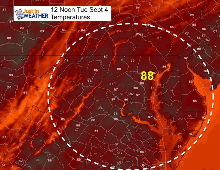
Tracking The Heat
Now Scheduling School Assemblies
- Storm Smart – Severe Weather (September, October; March through May)
- FITF – Snow and ice (November through March)
Programs for K through Middle School
Choose flat fee or FREE along with a spirit wear shirt fundraiser that earns your school money.
High Temperatures
Peak Heat Index values will be between 100ºF and 105ºF
Tropical Storm Gordon
LOCATION...27.7N 85.7W
ABOUT 230 MI...365 KM ESE OF THE MOUTH OF THE MISSISSIPPI RIVER
MAXIMUM SUSTAINED WINDS...65 MPH...100 KM/H
PRESENT MOVEMENT...WNW OR 300 DEGREES AT 17 MPH...28 KM/H
MINIMUM CENTRAL PRESSURE...1004 MB...29.65 INCHES
A Storm Surge Warning is in effect for...
* Shell Beach to Dauphin Island

A Storm Surge Watch is in effect for...
* West of Shell Beach to the Mouth of the Mississippi River
* East of Dauphin Island to Navarre

A Hurricane Warning is in effect for...
* Mouth of the Pearl River to the Alabama-Florida Border

A Tropical Storm Warning is in effect for...
* West of the Mouth of the Pearl River to east of Morgan City,
Louisiana, including Lake Pontchartrain and Lake Maurepas
* Alabama-Florida Border to Okaloosa-Walton County Line
Outlook
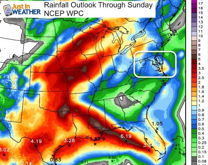
Rainfall Potential
The heaviest rain will be pushed inland well west of us, but some of this moisture will wrap around back in our direction.
Forecast Animation

 Get the award winning Kid Weather App I made with my oldest son and support our love for science, weather, and technology. Our 3 year anniversary of the release and our contribution to STEM education is this November. It has been downloaded in 60 countries, and works in both temperature scales. With your support we can expand on the fun introduction to science and real weather.
Temperature Outlook
Relief from the heat comes with the rain this weekend
Please share your thoughts, best weather pics/video, or just keep in touch via social media
-
Facebook: Justin Berk, Meteorologist
-
Twitter: @JustinWeather
-
Instagram: justinweather
Keep In Touch Every Day
Click here to sign up for email alerts…. Just in case you don’t get the post on your social media feed
Power Partner Just In Power Kids and Maryland Trek 5:

Still Time To Support Just In Power Kids
We are still taking donations for our best Maryland Trek yet. Every penny goes to Just In Power Kids programs to provide FREE holistic care for kids in cancer treatment and up to 5 years post treatment.
![]()