 Sunday September 2 2018
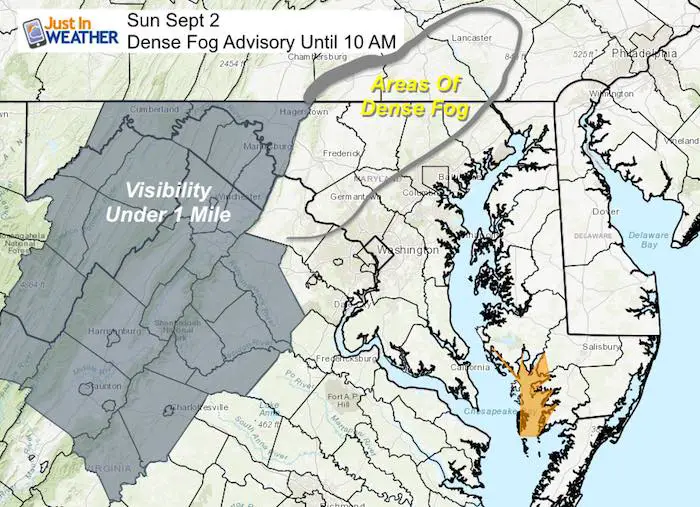
The strong and slow moving storms have left plenty of moisture around. That has prompted this Dense Fog Advisory in the mountains until 10 AM, but fog spreads outside of that region through central Maryland and southern PA. That is a signal of the humidity and it will remain sticky through Labor Day, but we have some improvement for your afternoon plans.
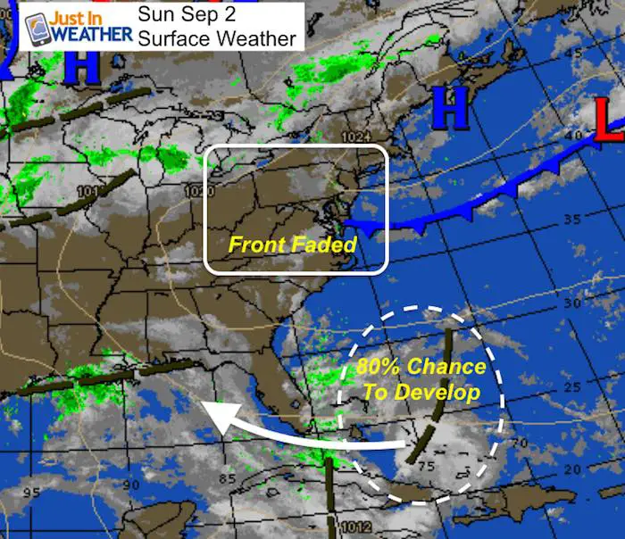
The stationary front that has been responsible for our slow moving storms has faded away. We lose the trigger in the atmosphere, so there will be less storms. However with the stickiness and some sun, we can still pop some afternoon showers that can dump a lot of rain locally. But it will be few and far between so no simulation to show. Don’t chance your Labor Day plans and if you get rain, consider yourself in the lucky spot. But the tropics are getting active and a new wave has an increased chance of 80% potential development in the Gulf of Mexico over the next five days.
Local Weather Stats For September 2 in Baltimore
Average High: 83ºF
Record High: 99ºF in 1953
Average Low: 62ºF
Record Low: 50ºF in 1862
Sunrise: 6:35 AM
Sunset 7:35 PM
*Daylight = 2:28 shorter than yesterday
*Bay Water Temperature = 81ºF at Thomas Pt. Light House
Also see: Winter Outlook From Two Different Farmers Almanacs
Quick Forecast Notes
Today and Monday:
- Morning clouds and some fog
- Afternoon: Partly Sunny, 30% of an afternoon storm. High mid to upper 80s
Watching The Topical Atlantic
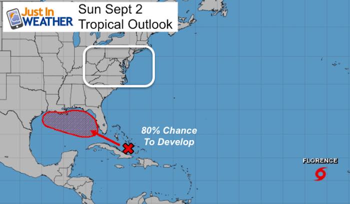
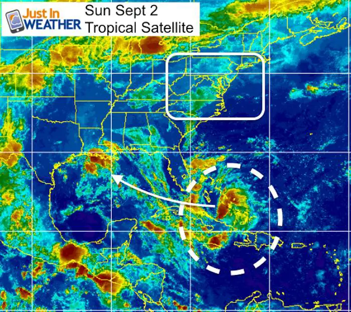
A few days ago I pointed out how slow this season had been and we were in the peak of development historically. The disturbance moving toward the Bahamas had little chance, but now appears to be entering the Gulf of Mexico at the right time with less wind sheer to allow for something to form. The National Hurricane Center has increased this potential to 80% over the next five days for a tropical storm to form. The next name on the list is Gordon.
Note: Florence will remain in the central Atlantic with no threat to land.
Closer Look

Forecast Outlook
The GFS Model shows the likely chance of Tropical Storm Gordon on Tuesday near New Orleans. The reason this is important is that it will follow the pattern over the last half of summer. Moisture gets pulled up from the Gulf into the central Plains and then wraps around, which can eventually move our way within a week. So watching this Tuesday could bring us more rain next weekend.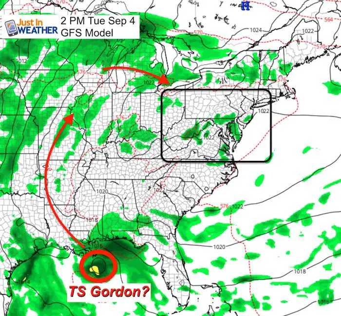
Farther out to the next week
I DO NOT like to point to specifics more than a week away in any season. This next map is a 276 Hour forecast! But here is the trend that shows a potential storm moving inland off of the Atlantic mid month. I would not lock on this day, but the idea of the pattern pushing inland to bring us more rain. Something to watch.
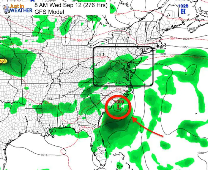
Here is the long range animation to show the flow

 Get the award winning Kid Weather App I made with my oldest son and support our love for science, weather, and technology. Our 3 year anniversary of the release and our contribution to STEM education is this November. It has been downloaded in 60 countries, and works in both temperature scales. With your support we can expand on the fun introduction to science and real weather.
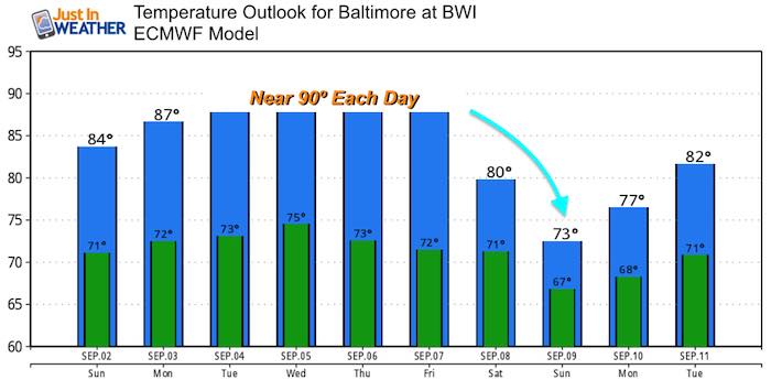
Temperature Outlook
Please share your thoughts, best weather pics/video, or just keep in touch via social media
-
Facebook: Justin Berk, Meteorologist
-
Twitter: @JustinWeather
-
Instagram: justinweather
Keep In Touch Every Day
Click here to sign up for email alerts…. Just in case you don’t get the post on your social media feed
Power Partner Just In Power Kids and Maryland Trek 5:

Still Time To Support Just In Power Kids
We are still taking donations for our best Maryland Trek yet. Every penny goes to Just In Power Kids programs to provide FREE holistic care for kids in cancer treatment and up to 5 years post treatment.
![]()