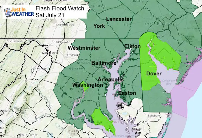
 Saturday 21 2018
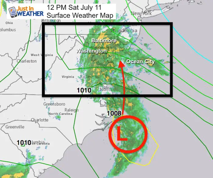
The rain has has ready moved in and there is no avoiding this strong storm. The only debate now will be the track of Low Pressure and where the heaviest rain will fall. At this time it looks like the heavier rain and strongest winds in metro Baltimore will be between 8 PM Saturday and 2 AM Sunday. But that means a few hours earlier in southern Maryland and the beaches, and a little later into southern PA. But the precise track of the core Low will determine if the worst flooding will be east or west of the Chesapeake Bay. The HRRR Model shows the worst case scenario, but the NAM 3 Km here is also pretty intense for most of the region. That is what will be tracked today.
This post is for three main points:
- Rain Timeline
- Storm Track/Heavy Rainfall
- Strongest Winds
I want to compare each element separately
Rain Timeline
Both models shows moderate rain increasing this afternoon and evening. The heaviest rain will reach
- 2 PM to 6 PM: Beaches
- 7 PM to Midnight: Central Southern Maryland/Western Bay
- 8 PM to 2 AM: Southern PA
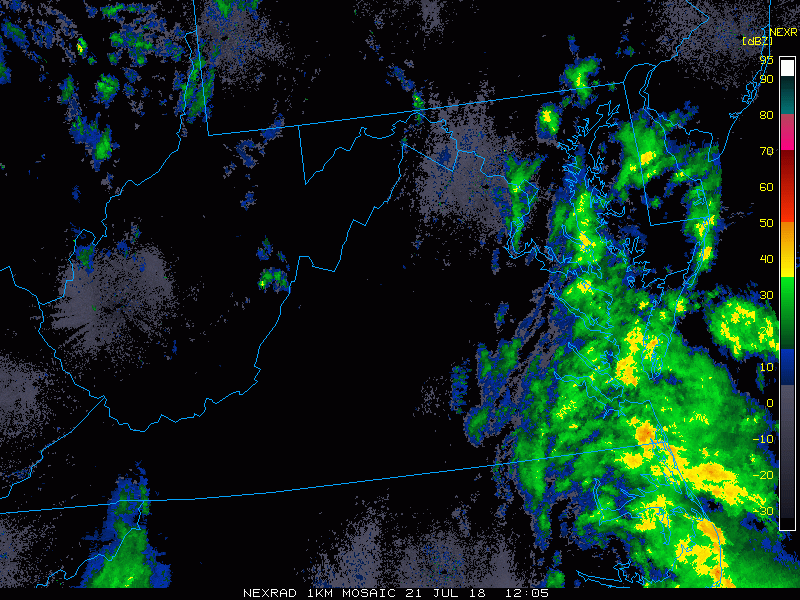
Radar Loop 8 AM to Noon
Here we see the developing storm and flow of rain to the north. The heavier rain is shaded yellow and orange
Radar Simulation
HRRR Model —> slider
This tracks the Low Pressure farther west
[metaslider id=64116]
NAM 3 Km Model —> slider
This tracks the Low Pressure farther west
[metaslider id=64143]
Storm Track/Heavy Rainfall
The storm track between the two high resolution models shown here is about 60 to 100 miles. The HRRR Model is farther west, bringing the heaviest rain band west of Baltimore and Washington to include Frederick. The NAM 3 Km (first to pick up on this storm hitting us hard) has the Low tracking over Ocean City and then curving northwest in the northern Delmarva to Harrisburg. That brings the stripe of heavy rain farther east of the cities. Check the estimated rain totals out here.
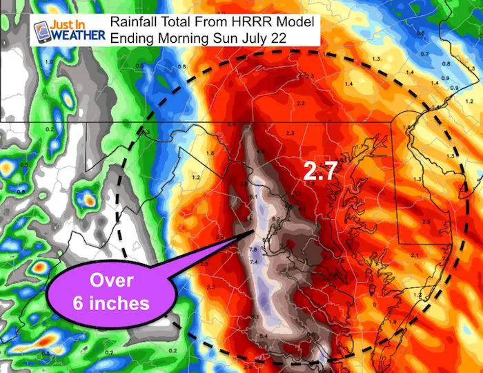
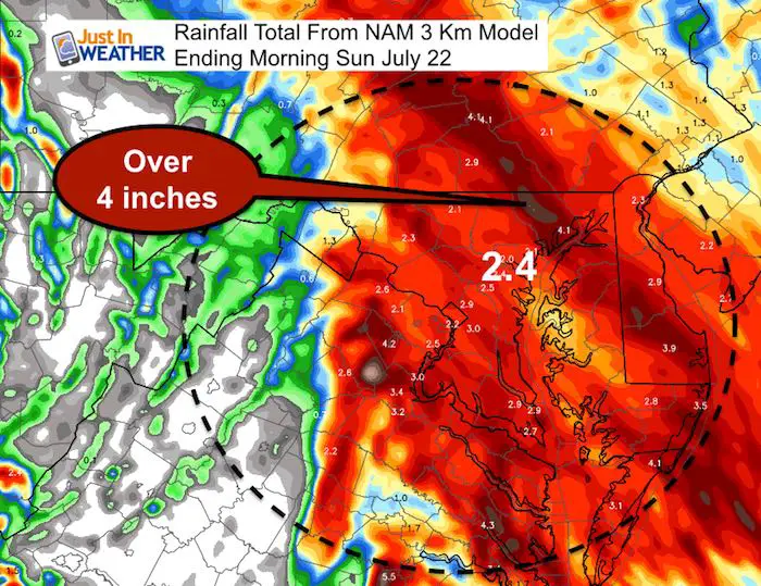
Even if we verify the lower end, the flooding potential is res and widespread. This may need to be expanded west depending on the track of the Low…
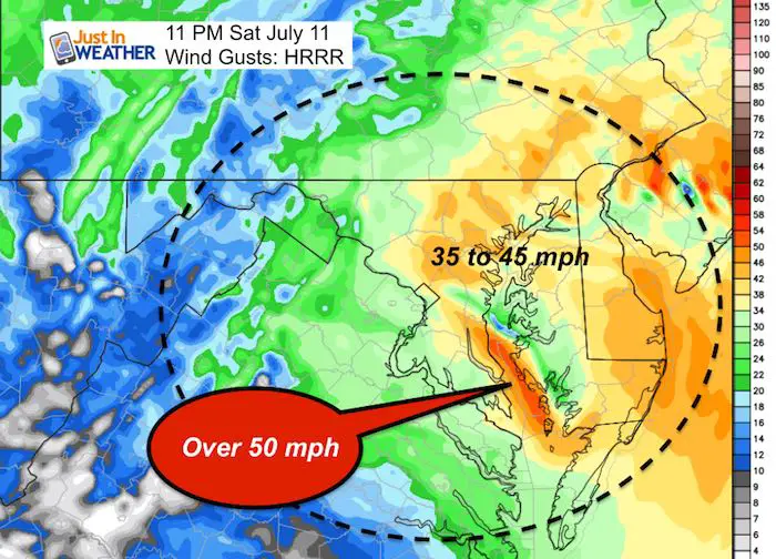
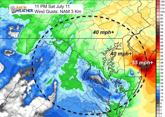
Strongest Winds
I have picked the 11 PM plot that shows the closest approach of the Low Pressure.
The HRRR Model plot fathers west brings the strongest winds over southern and central Maryland. The NAM keeps that strongest winds along the beaches.
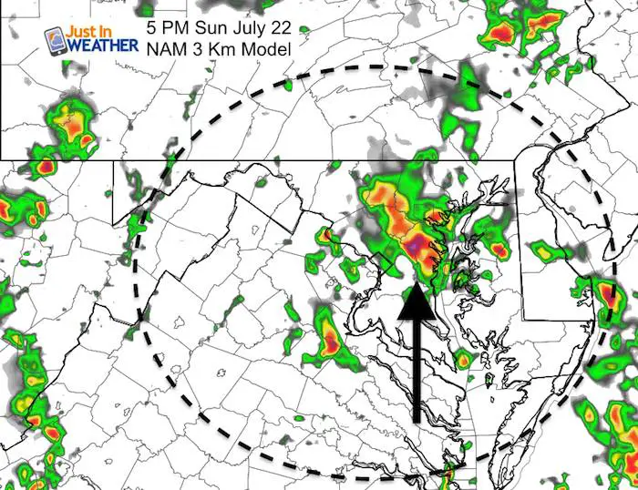
Sunday: Afternoon Storms May Turn Severe
The southerly flow will continue but the set up will be different. Instead of an organized larger storm, we will see clusters or cell develop in the afternoon. These will push south to north and some may turn severe
Please Support Maryland Trek 5
329 miles hiking and biking in 7 days
To provide free integrated wellness programs for kids in and post cancer treatment
Power Sponsor of Maryland Trek 5:

Please share your thoughts, best weather pics/video, or just keep in touch via social media
-
Facebook: Justin Berk, Meteorologist
-
Twitter: @JustinWeather
-
Instagram: justinweather
Keep In Touch Every Day
Click here to sign up for email alerts…. Just in case you don’t get the post on your social media feed
Shine On
Proceeds from all sales go to Just In Power Kids. Click the image to shop and show your support.

![]()
 Get the award winning Kid Weather App I made with my oldest son and support our love for science, weather, and technology. Our 3 year anniversary of the release and our contribution to STEM education is this November. It has been downloaded in 60 countries, and works in both temperature scales. With your support we can expand on the fun introduction to science and real weather.