Tuesday April 17 2018
It’s tax day and you may want a refund on the weather. After two days in the 80s, the cold air has fought back and will try to dominate for much of the rest of the month. Today, we continue with strong winds that have developed Lake Effect Snow Showers. Garrett County will be showing off with a few inches of snow, but locally some flakes may fly this afternoon in the form of flurries or a stray snow showers, especially on the north side. As the winds settle down and the sky clears tonight, a Freeze Watch is in place west of I-95. Then we at least get back to the 60s tomorrow. See the outlook for the rest of the month as we remain on the below normal side.
Stats For April 17
Average High: 65ºF
Record High: 93ºF in 2002
Average Low: 43ºF
Record Low: 26ºF in 1875
Snow Record: Trace in 2001
Seasonal Snow To Date (at BWI): 15.2
Sunrise: 6:26 AM
Sunset 7:46 PM
*Daylight = 2:26 longer than yesterday
*Bay Water Temperature = 50ºF at Thomas Pt. Light House
Keep In Touch Every Day
Click here to sign up for email alerts…. Just in case you don’t get the post on your social media feed
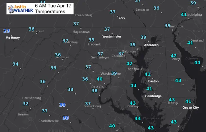
Morning Temperatures
This Afternoon
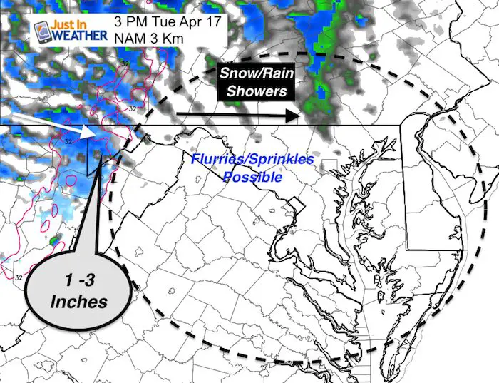
Strong winds will gust up to 25 mph and keep us partly to mostly cloudy. There will be snow adding up to 3 inches in Garrett County. After noon, showers will cross the mountains. There will be waves of snow or rain showers across northern Maryland and southern PA. So flakes may fly around York and maybe Westminster. Some sprinkles or flurries not showing up there could pass through central Maryland between 2 PM and 5 PM.
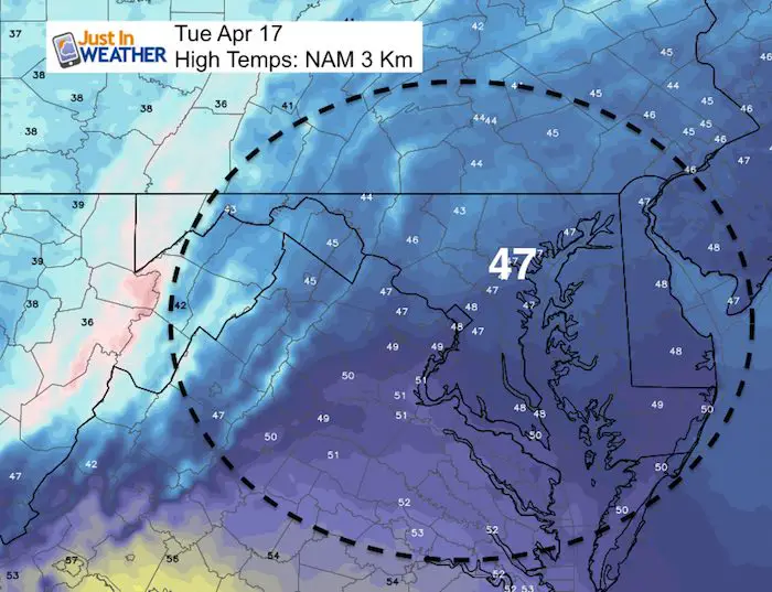
High Temperatures
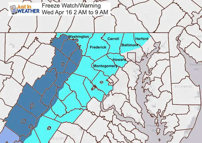
Freeze Watch/Warning
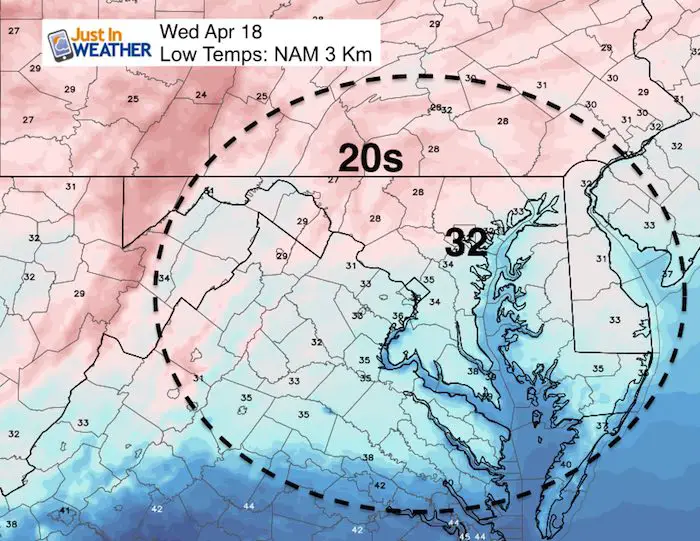
The normally colder areas inland will dip down into 20s tonight. Southern PA is not included on this map, but will be part of the freeze. The dark blue shaded areas are where the warning guarantees the coldest temps by tomorrow morning.
Low Temperatures
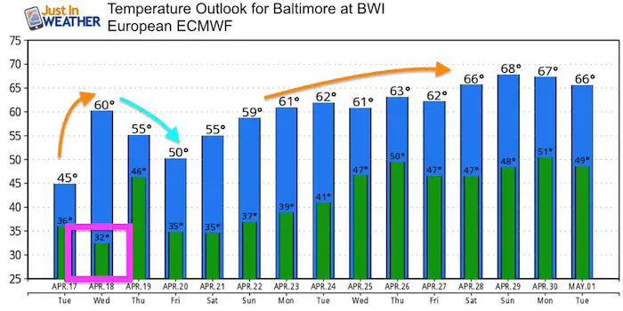
Looking Ahead
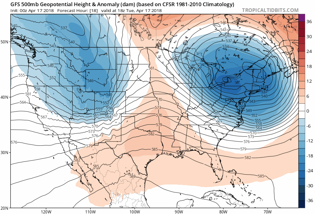
The jet stream wil be dominated by a cooler flow. While we may modify near normal next week, overall the rest of April is expected to remain on the cooler side. The temperatures will modify a little, but still remain a few degrees below where we should be to end the month.
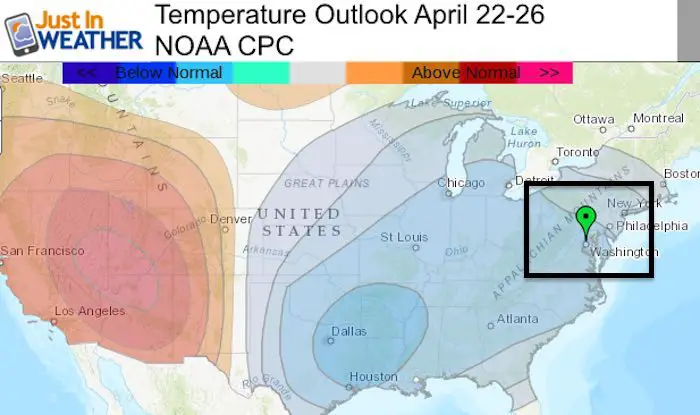
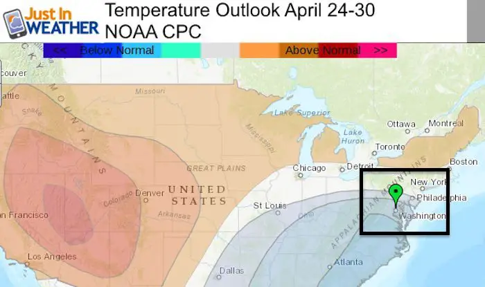
Temperature Outlook
![]()
Shine On
Proceeds from all sales go to Just In Power Kids. Click the image to shop and show your support.

 Get the award winning Kid Weather App I made with my oldest son and support our love for science, weather, and technology. Our 3 year anniversary of the release and our contribution to STEM education is this November. It has been downloaded in 60 countries, and works in both temperature scales. With your support we can expand on the fun introduction to science and real weather.
Also See:
My Winter Outlook 2017-2018 for more snow
La Nina Formed: What it could mean to our winter
NOAA Winter Outlook: Not The Best But Not The Worst For Snow
Two Farmers Almanacs Winter 2018 Outlooks
Winter Weather Folkore: Suggestions from Animals and Crops
First Frost and Freeze Dates For Maryland (southern PA and northern VA)
My Preliminary Winter Outlook Notes
Low Snow Winters In Baltimore: To Repeat Or Not Repeat
NOAA Ranks Blizzard 2016 4th Worst Snowstorm On Record
Blizzard 2016 Record Top Snowstorm: Area Totals
Extreme Weather of 2015 balanced out on both ends