 Sunday April 15 2018
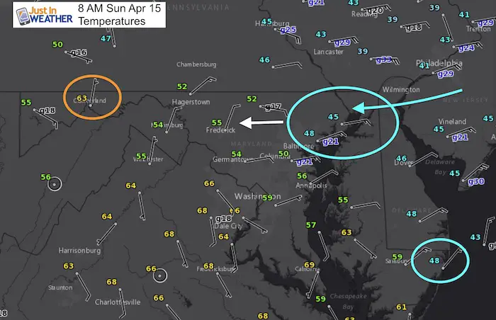
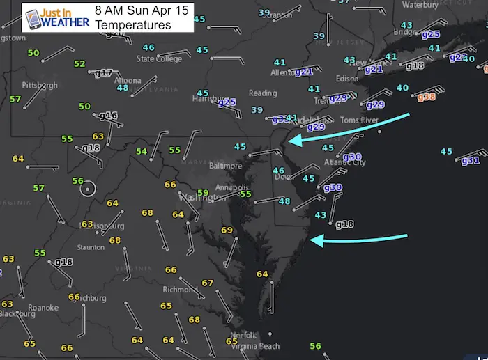
As quick as the heat arrived, it is gone! Baltimore hit a high of 86ºF on Saturday and today’s temperatures will continue to drop. The high will officially be in the upper 60s from midnight, but much of the day, including this afternoon will be in the 40s. Check out the 8 AM temperatures map above: The 40s have already moved into Harford and Cecil County… also in Ocean City. But Cumberland is till in the 60s. This backdoor front has shifted the winds from the east and taking that chilly Atlantic moisture to build in clouds and will develop rain. So as it cools off by you, rain will be developing as well. See the rain timelines below. One slider shows today’s rain, which will also show heavy storms this afternoon moving north. Then the strong line of storms from the west we carry in a separate slider through Monday morning.
Stats For April 15
Average High: 65ºF
Record High: 88ºF in 1941
Average Low: 43ºF
Record Low: 31ºF in 1973
Snow Record: 0.3″ in 1923
Seasonal Snow To Date (at BWI): 15.2
Sunrise: 6:29 AM
Sunset 7:44 PM
*Daylight = 2:29 longer than yesterday
*Bay Water Temperature = 51ºF at Thomas Pt. Light House
Keep In Touch Every Day
Click here to sign up for email alerts…. Just in case you don’t get the post on your social media feed
Morning Temperatures
Temperature Timeline —> slider
This hourly breakdown shows the expanding push of colder air. Watch at Baltimore drops into the 40s, but also as warmer air will try to return this evening. See the afternoon reach the 70s in central Virginia and try to push back. Salisbury may reach the 60s again this evening… along with rain (see below)
[metaslider id=61234]
Radar Simulation Today —> slider
[metaslider id=61259]
Storm Timeline Overnight/Monday Morning—> slider
[metaslider id=61288]
Storm Animation
The distinct storm line arrives overnight into Monday morning. Then watch as snow (blue) builds back into Western Maryland through Tuesday morning.
![]()
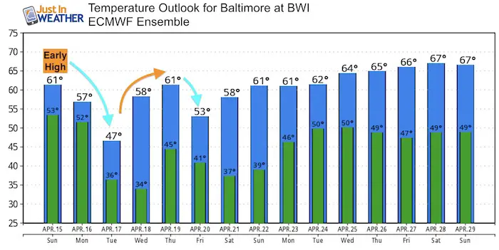
Temperature Outlook
![]()
Shine On
Proceeds from all sales go to Just In Power Kids. Click the image to shop and show your support.

 Get the award winning Kid Weather App I made with my oldest son and support our love for science, weather, and technology. Our 3 year anniversary of the release and our contribution to STEM education is this November. It has been downloaded in 60 countries, and works in both temperature scales. With your support we can expand on the fun introduction to science and real weather.
Also See:
My Winter Outlook 2017-2018 for more snow
La Nina Formed: What it could mean to our winter
NOAA Winter Outlook: Not The Best But Not The Worst For Snow
Two Farmers Almanacs Winter 2018 Outlooks
Winter Weather Folkore: Suggestions from Animals and Crops
First Frost and Freeze Dates For Maryland (southern PA and northern VA)
My Preliminary Winter Outlook Notes
Low Snow Winters In Baltimore: To Repeat Or Not Repeat
NOAA Ranks Blizzard 2016 4th Worst Snowstorm On Record
Blizzard 2016 Record Top Snowstorm: Area Totals
Extreme Weather of 2015 balanced out on both ends