 Thursday April 5 2018
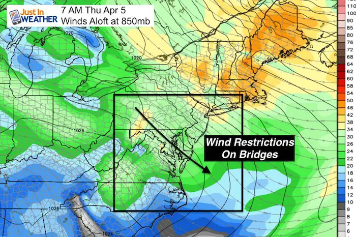
The winds have been roaring overnight and restrictions are in place on area bridges this morning with gusts still to 30 mph. Overall this is setting us up for a chilly stretch through the weekend, but there will be a brief warm up on Friday. The main story will be the snow on Saturday but I have been downplaying snow totals and the latest computer modeling shows why. More on that below, plus the cold air on Sunday morning will challenge record lows and make for a very cold Cherry Blossom 10 Miler in Washington.
Stats For April 5
Average High: 61ºF
Record High: 84ºF in 2010
Average Low: 40ºF
Record Low: 25ºF in 1881
Snow Record: 0.1″ in 1944
Seasonal Snow To Date (at BWI): 15.2
Sunrise: 6:44 AM
Sunset 7:34 PM
*Daylight = 2:32 longer than yesterday
*Bay Water Temperature = 45ºF at Thomas Pt. Light House
Keep In Touch Every Day
Click here to sign up for email alerts…. Just in case you don’t get the post on your social media feed
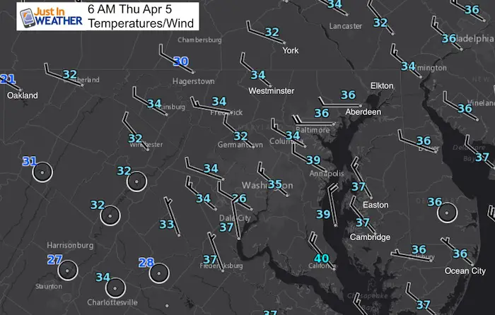
Morning Temps
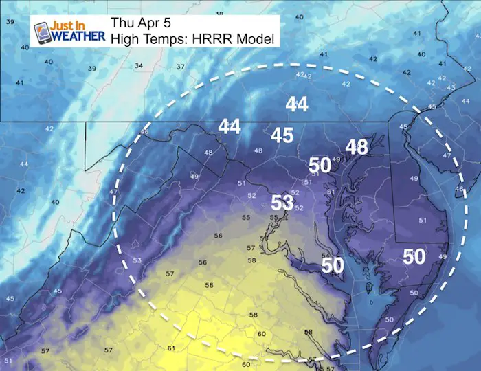
Afternoon Highs
Friday Morning
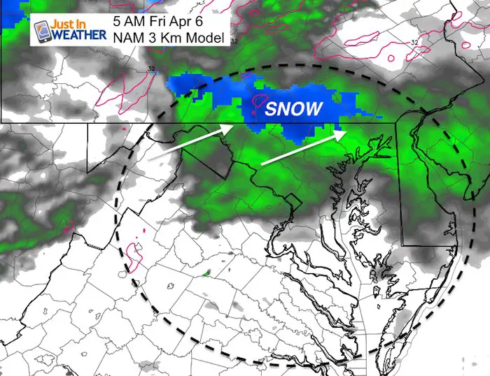
There will be a little system moving through to the north with a rain and snow mix. This will be light and brief, and is the leading edge of warmer air. It should not be a road issue for most of us.
Wintry Weekend (and early next week)
The snow event on Saturday may start as rain in the morning and then snow most of the day. This is a daytime event that will have trouble sticking in the April sun. At this time I have to lean towards most roads being wet.
- For snow to be a factor, it must begin before 8 AM and stay to lay quickly.
- The evening part may be slick if snow can linger beyond 6 PM. Temperatures will be dropping into the 20s Sunday morning, so there may be icing.
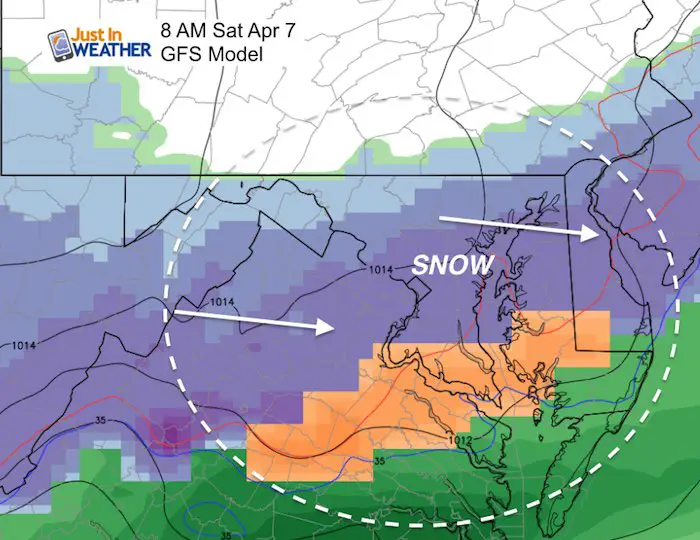
GFS Model
This has been most aggressive with snow starting early in the morning. But see the animation of the Canadian Model below…
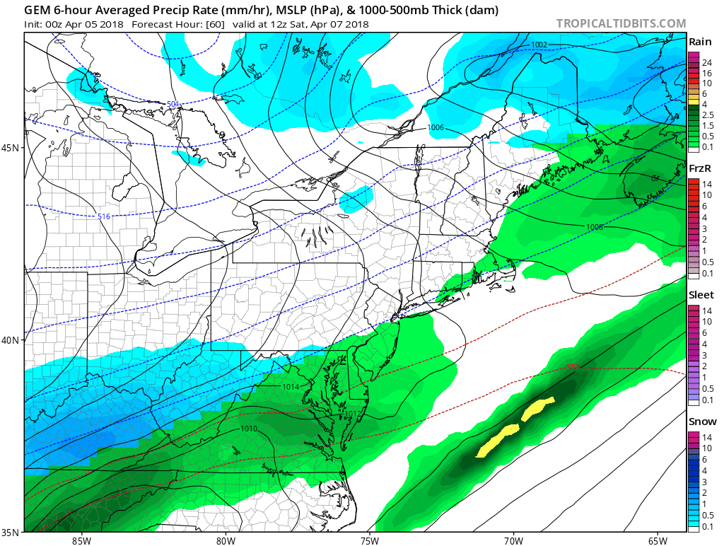
Canadian GEM Model
This model animation shows rain in the morning switching to snow before noon. That would make all of the difference with setting up a layer of snow and stickage or remaining wet. I have included the outlook to early next week with another hit of snow/rain mix Monday and Tuesday.
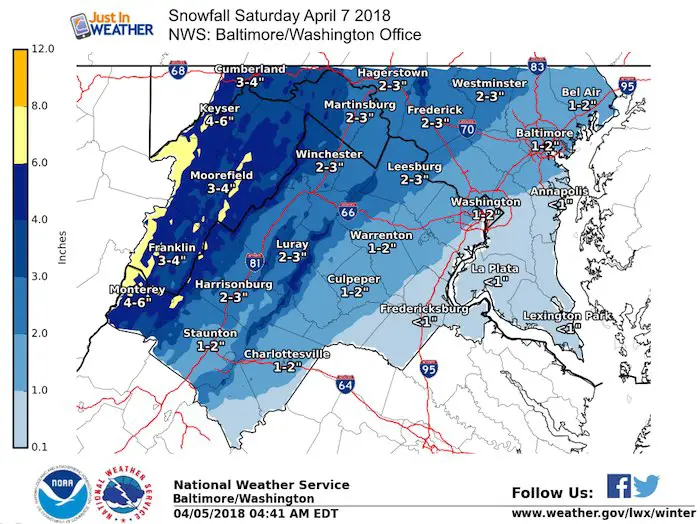
How Much Snow?
The National Weather Service has a more realistic outlook than the computer models you may have seen floating around online. We still need to firm up the start time to allow for a layer to stick before the sun gets too high in the sky. I will have my first call snowfall map this evening.
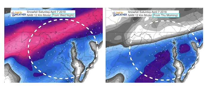
I have played this event conservatively as I did not trust the high numbers on the computer modeling. I still don’t. There was an abrupt cut off of snow on the north end in the latest run. Compare the NAM 12 Km Snow forecast last night to the model update this morning. It went from 12″ in Frederick to southern PA to nothing. Meanwhile shifting higher amounts south of Washington DC. I have a hard time seeing this all stick during the daytime.
NAM 12 Km
This shows the abrupt cut off on the north side as the system shows a shift to the south. I expect this to spread north again, but proof that the computer models can not be locked in on any particular model. Theses products were produced 6 hours apart.
April Snow Records
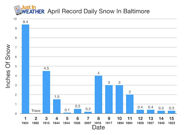
- The largest single day event was on April 1, 1924 with 9.4 inches
- April 10-11 in 1894: Two day event totaled 5 inches.
- 1916 on April 8th there was 4 inches.
- 1917 ONE YEAR LATER on April 9th there was 3 inches.
- 2007 Most Recent Impact on April 7 with 0.2 inches in Baltimore
Later Snows:
- April 17 and 18 in 2001 both has a trace
1980s
- 1983 April 19 and 20th both a trace
- 1984 April 20th = Trace
- 1986 April 23rd = Trace
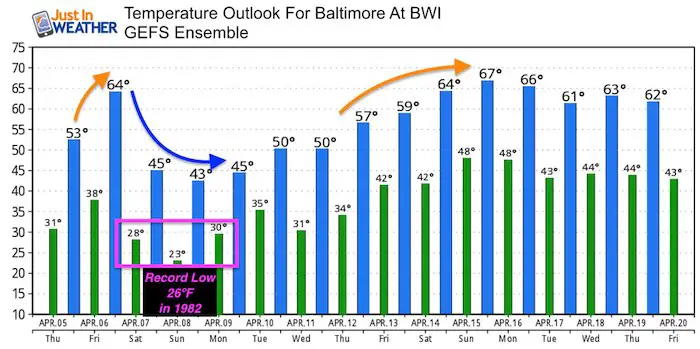
Temperature Outlook
The record Low on April 8 in Baltimore is 26ºF set in 1982.
Shine On
Proceeds from all sales go to Just In Power Kids. Click the image to shop and show your support.

![]()
 Get the award winning Kid Weather App I made with my oldest son and support our love for science, weather, and technology. Our 3 year anniversary of the release and our contribution to STEM education is this November. It has been downloaded in 60 countries, and works in both temperature scales. With your support we can expand on the fun introduction to science and real weather.
Also See:
My Winter Outlook 2017-2018 for more snow
La Nina Formed: What it could mean to our winter
NOAA Winter Outlook: Not The Best But Not The Worst For Snow
Two Farmers Almanacs Winter 2018 Outlooks
Winter Weather Folkore: Suggestions from Animals and Crops
First Frost and Freeze Dates For Maryland (southern PA and northern VA)
My Preliminary Winter Outlook Notes
Low Snow Winters In Baltimore: To Repeat Or Not Repeat
NOAA Ranks Blizzard 2016 4th Worst Snowstorm On Record
Blizzard 2016 Record Top Snowstorm: Area Totals
Extreme Weather of 2015 balanced out on both ends