Tuesday April 3 2018
We are stuck right on the edge of warm air that will briefly reach us, but that will keep us on the track for rain. Today, showers will pass through, with steady rain on the north side through PA. A line of thunderstorms possible tomorrow that will be followed by a sharp cool down and set the stage for a few snow events. It is April and will be tough to get stickage… But we are not done with snow yet.
Stats For April 3
Average High: 60ºF
Record High: 88ºF in 1963
Average Low: 39ºF
Record Low: 27ºF in 2013
Snow Record: 4.5″ in 1915
Seasonal Snow To Date (at BWI): 15.2
Sunrise: 6:47 AM
Sunset 7:32 PM
*Daylight = 2:33 longer than yesterday
*Bay Water Temperature = 45ºF at Thomas Pt. Light House
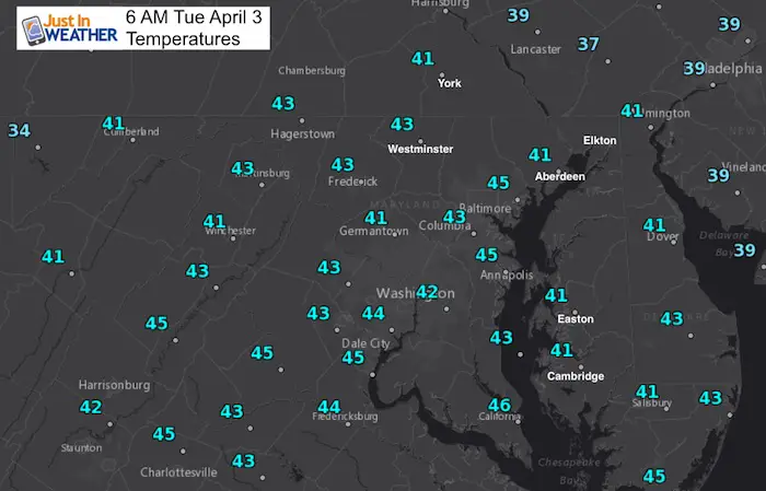
Morning Temperatures
Rain Timeline: Radar Simulation —> Radar
[metaslider id=60901]
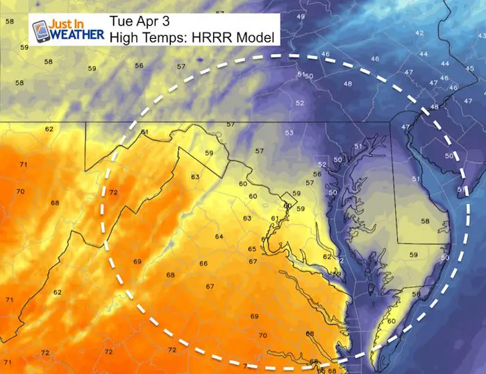
Afternoon Highs
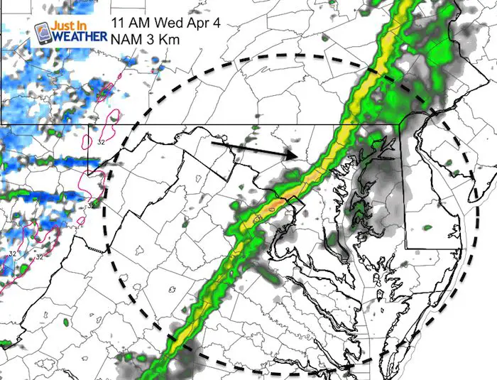
Wednesday T’Storms
This looks like a late morning event for Baltimore then on the Eastern Shore during the afternoon. A line of rain with some thunder could also have wind gusts over 40 mph as it ushers in colder air again. This will be a day with warmer temperatures and strong winds, then the colder air spills in overnight.
Snow Potential
The weather pattern supports a few rounds of snow, but the modeling is all over the place. Here I want to show you the standard GFS Model and one that I have grown to like… The ICON. This is the model that was first to show the Monday snow staying farther north. Here, it shows snow deep into Maryland this weekend. Obviously there is little agreement event here as the timing of the impulse is different, but there is going to be some snow to end the week and maybe keep those little league fields muddy.
GFS Model
This model brings in snow on Saturday.
ICON Model
This model shows snow in PA on Friday, then a southern push for Saturday night into Sunday.
![]()
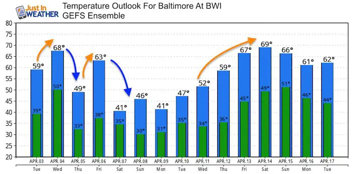
Temperature Outlook
This is truly an abrupt pattern adjustment. We will still have some freezing mornings into early next week.
Shine On
Proceeds from all sales go to Just In Power Kids. Click the image to shop and show your support.

![]()
 Get the award winning Kid Weather App I made with my oldest son and support our love for science, weather, and technology. Our 3 year anniversary of the release and our contribution to STEM education is this November. It has been downloaded in 60 countries, and works in both temperature scales. With your support we can expand on the fun introduction to science and real weather.
Also See:
My Winter Outlook 2017-2018 for more snow
La Nina Formed: What it could mean to our winter
NOAA Winter Outlook: Not The Best But Not The Worst For Snow
Two Farmers Almanacs Winter 2018 Outlooks
Winter Weather Folkore: Suggestions from Animals and Crops
First Frost and Freeze Dates For Maryland (southern PA and northern VA)
My Preliminary Winter Outlook Notes
Low Snow Winters In Baltimore: To Repeat Or Not Repeat
NOAA Ranks Blizzard 2016 4th Worst Snowstorm On Record
Blizzard 2016 Record Top Snowstorm: Area Totals
Extreme Weather of 2015 balanced out on both ends