 March 22 2018
The totals are in for the Spring Snowstorm, the 4th Nor’easter in a row that finally hit the Mid Atlantic. This was the largest snow event since our all time record storms in January 2016 and the largest March snowfall since 2013. This was talked about for over a week and definitely not an easy forecast. I was very cautious of large snow amounts due to warm ground, late March sun angle on the Equinox, and temperatures near/above freezing. In this case, the heavy snowfall rates were stronger than the sun and winter weather won.
The regional official reporting stations were on the lower end and will not serve justice to this storm. Baltimore’s BWI had 4.7″ yet are on the map in the general 6 to 8 inch zone. How does this map and the local maps in the slider below compare to what you had?
*Note: I have links to our new nonprofit Just In Power Kids and the Shine On Shirts at the bottom of this post. Thank you all for your kind words and support for this incredible venture.
Airport Reports
BWI = 4.7″ Storm Total; Seasonal Total = 15.2″
Washington National = 4.1″ Storm Total; Seasonal Total = 7.8″
Dulles = 4.8″ Storm Total *Record for the date
Seasonal Total = 11.9″
Harrisburg International = 14.2″ Storm Total; *Record 11.9 for March 21; Seasonal Total = 33.7″
Compacting Snow = Lower Depth Than What Fell

I was in the snow zone and had 11 inches on the ground Tuesday night with Round 1. The places that were cleared (like my driveway) had an additional 9 inches of snow on Wednesday. We had a Toal of 20 inches measured in multiple locations. But the total ground depth compacted to a range of 14 to 16 inches. Yet according to the NWS map we are in the 12″+ zone. Snowfall is not always reflected well on these maps.
Below is a look at my final snowfall forecast and the local maps from the NWS Baltimore/Washington region. That is all that is available at post time. Please compare and then grade my forecast. While there was an adjustment on the higher end of my forecast, I hope the information I have shared was easy to understand and helped you plan.
What went wrong:
- Tuesday March 20: The initial sleet and snow in the morning was more intense than expected. That covered the ground and allowed more snow to add up in the colder zones. I expected 1 to 3 inches by evening mostly on the grass. Instead many were already in the 6 to 10 inch range. THAT WAS JUST ROUND 1.
- The arrival of the snow Wednesday was 2 to 3 hours later than expected, this also kept the snow around longer on the back end. But I did discuss it lasting all day and into the night.
What went right:
- The storm came together as expected.
- This was a two day event with the biggest hot on the second day.
- When I adjusted for the first day snow totals, the second phase verified most of my final forecast.
GRADE MY FORECAST
Please see the maps and stats below, then go back to the social media post where you saw this and Grade My Forecast as best you see it. I give myself a B-. I lost the most points with the day 1 snow in the snow zone. Then with snow beating the sun for stickage. Overall, this storm did work out and overachieve.
My Final Forecast
The map is the same, but totals increased just a little from my initial forecast. There are two numbers. The Additional Snowfall from Tuesday evening through Wednesday AND the FINAL TOTAL.
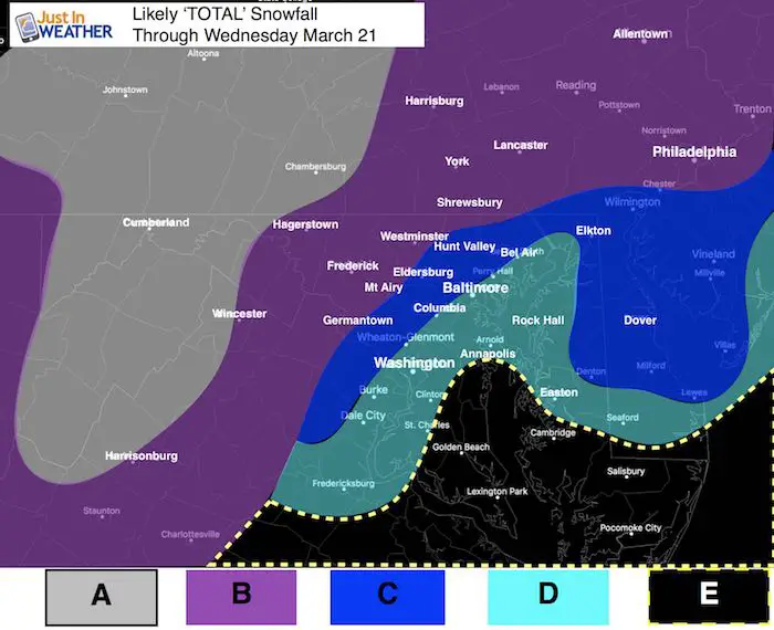
A: 12 to 20 inches total
B: 6 to 12 inches Additional Snow. TOTAL SNOW: 12 to 20 inches
- Yes, many parts of this region already had 4 to 8 inches as of Tuesday evening. That was the overachiever. The rest is what close to what I originally expect to start adding up from this point forward.
C: 6 to 12 inches Additional Snow. TOTAL SNOW 8 to 14 inches
D: 4 to 8 inches TOTAL *If I bust here, it will be because I am too low. I am banking on snow compacting and melting here.
E: Slushy 3 to 6 inches. Snow will be expanding during the day and into Wednesday night on the Eastern Shore. The daytime snow will battle temps in the mid 30s and sun angle. If there are heavier rates of snow, that could compensate the melting and go higher.
Snow Spotter Reports —> slider
County reports from NWS Baltimore Washington region. This is all that is available at post time. See the list below the slider
Full list of town reports below…
[metaslider id=60616]
Snow Spotter List
Note: Southern PA did get an average of 14 to 20 inches across Adams and York Counties but the reporting is not as organized from NWS State College PA
LOCATION          STORM TOTAL     TIME/DATE   COMMENTS
                     SNOWFALL           OF
                     /INCHES/   MEASUREMENT

DISTRICT OF COLUMBIA

...District of Columbia...
   National Zoo 1 WSW     4.1   136 PM  3/21  Trained Spotter

MARYLAND

...Allegany County...
   Ridgeley 1 NW         12.0   700 PM  3/21  Trained Spotter
   Frostburg             11.0   918 AM  3/21  Trained Spotter
   Frostburg 2 ENE       10.5   602 PM  3/21  Trained Spotter
   Frostburg 2 ESE       10.0   425 PM  3/21  Trained Spotter

...Anne Arundel County...
   Londontowne 3 SW       8.8   700 PM  3/21  CoCoRaHS
   Riva 2 WNW             7.5   430 PM  3/21  Trained Spotter
   Riva 2 N               7.0  1238 PM  3/21  NWS Employee
   Herald Harbor 1 NW     6.3   335 PM  3/21  Trained Spotter
   Annapolis 1 NW         6.3   240 PM  3/21  Trained Spotter
   Odenton 1 WNW          6.2   205 PM  3/21  Trained Spotter
   Odenton 1 N            6.1  1255 PM  3/21  Trained Spotter
   Crownsville 3 SSW      6.0   630 PM  3/21  Trained Spotter
   Crofton 2 NNE          6.0   230 PM  3/21  NWS Employee
   Green Haven 1 ESE      5.8   415 PM  3/21  Trained Spotter
   Georgetown 1 ESE       5.5   445 PM  3/21  Trained Spotter
   Pasadena 1 ENE         5.0   133 PM  3/21  Trained Spotter
   BWI Airport          4.7  800 PM  3/21  Airport
   Ridgeway 1 N           4.6  1245 PM  3/21  CoCoRaHS
   Severn  NE             4.5  1256 PM  3/21  Trained Spotter
   Fort Meade 2 ESE       4.2  1212 PM  3/21  Trained Spotter

...Baltimore County...
   Parkton  S            11.3   500 PM  3/21  Trained Spotter
   Bentley Springs 1 E   11.0   550 PM  3/21  Trained Spotter
   Parkton 1 W           10.4   700 PM  3/21  Trained Spotter
   Brooklandville 2 NNW   8.2   500 PM  3/21  Trained Spotter
   Long Green 2 NW        7.5   400 PM  3/21  Trained Spotter
   Glyndon 1 WSW          7.2   145 PM  3/21  Trained Spotter
   Reisterstown           7.0   105 PM  3/21  Local Official
   Cockeysville           7.0  1256 PM  3/21  Broadcast Media
   Middle River 1 N       6.5   400 PM  3/21  Trained Spotter
   Catonsville 1 SSE      4.5   700 PM  3/21  Trained Spotter
   White Marsh 1 ENE      4.5   900 PM  3/21  Trained Spotter
   Perry Hall 1 NNE       4.5   300 PM  3/21  Trained Spotter
   Lansdowne 1 ESE        4.1   200 PM  3/21  Trained Spotter
   Perry Hall 2 E         4.0   300 PM  3/21  Trained Spotter
   Rossville 1 NE         3.8   226 PM  3/21  Trained Spotter

...Baltimore City...
   Lochearn 2 ENE         6.5   615 PM  3/21  Trained Spotter
   Pikesville 2 SE        6.4   300 PM  3/21  CoCoRaHS
   Pimlico  SE            6.0   400 PM  3/21  Trained Spotter
   Arbutus 2 NNE          5.5   804 PM  3/21  Trained Spotter

...Calvert County...
   Huntingtown 2 WNW      8.0   545 PM  3/21  Trained Spotter
   Prince Frederick 1 S   7.3   645 PM  3/21  Trained Spotter
   Saint Leonard 2 WSW    7.0   305 PM  3/21  Trained Spotter
   Dunkirk 2 SSW          6.5   620 PM  3/21  Trained Spotter
   Huntingtown 2 SW       5.8   655 PM  3/21  Trained Spotter
   Chesapeake Beach 4 S   5.5   500 PM  3/21  CoCoRaHS
   Dares Beach 3 NNW      5.0   100 PM  3/21  Trained Spotter
   Drum Point 2 N         4.5   645 PM  3/21  Trained Spotter
   Dares Beach 1 WNW      4.0   102 PM  3/21  Trained Spotter

...Carroll County...
   Lineboro 3 WSW        13.5   406 PM  3/21  Trained Spotter
   Millers 4 NE          12.5   431 PM  3/21  Co-Op Observer
   Westminster 2 SE      12.3   450 PM  3/21  Trained Spotter
   Wagners Mill 2 S      11.0   600 PM  3/21  Trained Spotter
   Westminster  SE       10.2   400 PM  3/21  Trained Spotter
   Lineboro 2 E          10.0  1215 PM  3/21  Trained Spotter
   Winfield 2 WSW         9.5   140 PM  3/21  Trained Spotter
   Oakland  NE            7.3   400 PM  3/21  Trained Spotter
   Gamber 1 WNW           6.6   200 PM  3/21  NWS Employee

...Charles County...
   Hughesville 2 ENE      5.7   430 PM  3/21  Trained Spotter
   Benedict 2 NW          5.5   109 PM  3/21  Trained Spotter
   Bryantown 2 NE         5.5   110 PM  3/21  Trained Spotter
   Bryantown 3 N          5.0   121 PM  3/21  Trained Spotter
   Dentsville 1 SW        4.2   400 PM  3/21  Trained Spotter
   Dentsville 1 E         3.5   135 PM  3/21  Trained Spotter
   La Plata 1 SW          3.5   123 PM  3/21  Trained Spotter
   La Plata 1 W           3.2   200 PM  3/21  Trained Spotter
   White Plains 3 NW      3.0   118 PM  3/21  Trained Spotter
   Port Tobacco Village   3.0   140 PM  3/21  Trained Spotter

...Frederick County...
   Thurmont 3 N          16.5   900 PM  3/21  NWS Employee
   Sabillasville 2 SSE   15.0   100 PM  3/21  Trained Spotter
   Bloomfield 2 WSW      14.9   500 PM  3/21  NWS Employee
   Bloomfield 1 SSE      13.5  1200 PM  3/21  Trained Spotter
   Myersville 2 SE       13.0   430 PM  3/21  Public
   Walkersville 1 E      12.0   355 PM  3/21  Trained Spotter
   Braddock Heights 1 N  12.0   300 PM  3/21  Trained Spotter
   New Market 2 NW        9.0  1200 PM  3/21  NWS Employee
   Ballenger Creek        8.5   700 PM  3/21  Trained Spotter
   Ballenger Creek 1 W    4.1   551 PM  3/21  Trained Spotter

...Harford County...
   Norrisville 1 WSW     13.0   640 PM  3/21  CoCoRaHS
   Bel Air 2 W            9.8   630 PM  3/21  Trained Spotter
   Scarboro 2 E           9.0   750 PM  3/21  Trained Spotter
   Bynum 1 SW             8.5   415 PM  3/21  Trained Spotter
   Whiteford              8.0   340 PM  3/21  Trained Spotter
   Bel Air                7.8   128 PM  3/21  County Emrg Mgmt
   Perryman 2 W           5.8   413 PM  3/21  Other Federal
   Abingdon 3 WNW         4.6   115 PM  3/21  Other Federal

...Howard County...
   Oella 1 NW             7.5   730 PM  3/21  Trained Spotter
   Columbia 2 N           7.2   530 PM  3/21  Trained Spotter
   Columbia               7.0  1245 PM  3/21  NWS Employee
   Savage 1 N             6.5   105 PM  3/21  Trained Spotter
   Savage 1 ESE           5.9   110 PM  3/21  Trained Spotter
   Scaggsville 1 ENE      5.5   330 PM  3/21  NWS Employee
   Columbia 2 NE          5.0   648 PM  3/21  Trained Spotter

...Montgomery County...
   Clarksburg 2 SE        6.3   930 PM  3/21  Public
   Takoma Park            6.0   153 PM  3/21  Trained Spotter
   Rockville 3 NNW        5.9   530 PM  3/21  NWS Employee
   Olney 1 SE             5.5   745 PM  3/21  CoCoRaHS
   Damascus 3 SSW         5.3   422 PM  3/21  Co-Op Observer
   White Oak 1 W          5.3   413 PM  3/21  Trained Spotter
   Norbeck 2 W            5.2  1249 PM  3/21  NWS Employee
   Norbeck 1 ESE          4.6   200 PM  3/21  Trained Spotter
   Takoma Park 1 ESE      4.5   115 PM  3/21  Trained Spotter
   Ednor 1 WNW            4.4   215 PM  3/21  Trained Spotter
   Poolesville            4.0   340 PM  3/21  Co-Op Observer
   Four Corners 1 N       3.8  1245 PM  3/21  Trained Spotter
   Montgomery Village 1   3.7   943 PM  3/21  1.19" LIQUID
   Spencerville  WSW      3.5   808 PM  3/21  Trained Spotter
   Four Corners 2 NW      3.3   345 PM  3/21  Trained Spotter
   Montgomery Village 1   3.3   300 PM  3/21  CoCoRaHS
   Montgomery Village 1   2.9   500 PM  3/21  Trained Spotter

...Prince Georges County...
   Greenbelt              6.9   530 PM  3/21  CoCoRaHS
   Cheltenham 1 NNE       6.8   230 PM  3/21  Trained Spotter
   University Park 1 E    6.5   227 PM  3/21  NWS Office
   Laurel 2 N             6.0   200 PM  3/21  Trained Spotter
   Forest Heights 1 S     4.5   400 PM  3/21  Trained Spotter

...St. Marys County...
   Clements 2 WSW         5.8   445 PM  3/21  Trained Spotter
   Mechanicsville 1 WNW   5.2   140 PM  3/21  Trained Spotter
   Mechanicsville 2 N     5.0  1245 PM  3/21  Trained Spotter
   Callaway 2 W           4.5   300 PM  3/21  Trained Spotter
   Park Hall 1 NNE        3.3   645 PM  3/21  Trained Spotter
   Great Mills 1 NNE      3.0   252 PM  3/21  Trained Spotter
   Callaway 3 SSW         1.5  1255 PM  3/21  Trained Spotter

...Washington County...
   Fairplay 3 SW         13.5   741 PM  3/21  Trained Spotter
   Maugansville 1 NE     13.0   100 PM  3/21  Hagerstown Airport
   Long Meadow 1 SSE     12.5   220 PM  3/21  Trained Spotter
   Long Meadow 1 WNW     12.5   600 PM  3/21  Trained Spotter
   Boonsboro 3 NNE       12.1   900 PM  3/21  Trained Spotter
   Pecktonville 3 NNW    11.0  1245 PM  3/21  NWS Employee
   Hagerstown 1 NNE       9.0   620 PM  3/21  Trained Spotter

VIRGINIA

...Albemarle County...
   Carrsbrook 3 WNW       7.0   615 PM  3/21  Trained Spotter
   Earlysville 3 NW       6.4   900 AM  3/21  Trained Spotter
   Free Union             5.0   800 AM  3/21  Broadcast Media
   Crozet 1 SSE           5.0  1222 PM  3/21  Trained Spotter
   Hollymead 1 NNW        5.0   110 PM  3/21  Trained Spotter
   Earlysville            5.0   800 AM  3/21  Broadcast Media
   Crozet                 5.0   800 AM  3/21  Broadcast Media
   Boyd Tavern 1 S        4.1  1220 PM  3/21  Trained Spotter
   Crozet 1 W             4.1   920 AM  3/21  CoCoRaHS

...Arlington County...
   Reagan National Apt    4.1   800 PM  3/21  Airport
   Barcroft 2 E           3.0  1249 PM  3/21  Trained Spotter
   Westover 1 NNE         3.0   315 PM  3/21  Trained Spotter

...Augusta County...
   Fishersville  NE      10.8   200 PM  3/21  Trained Spotter
   Moscow 3 S            10.5   920 AM  3/21  Trained Spotter
   Churchville            9.0   600 AM  3/21  Broadcast Media
   Hermitage 4 SW         8.8   800 AM  3/21  Trained Spotter
   Greenville             8.0   800 AM  3/21  Broadcast Media
   Churchville 4 NNW      8.0   953 AM  3/21  Trained Spotter
   Waynesboro             7.0   800 AM  3/21  Broadcast Media
   Waynesboro 2 WSW       6.5   815 AM  3/21  Trained Spotter
   Stuarts Draft          6.0  1218 PM  3/21  Trained Spotter
   Weyers Cave 1 SSW      6.0   150 PM  3/21  Trained Spotter
   Weyers Cave  WSW       5.5   909 AM  3/21  Trained Spotter

...City of Alexandria...
   Alexandria 1 W         3.5   315 PM  3/21  Trained Spotter

...City of Charlottesville...
   Charlottesville 1 NN   5.0  1245 PM  3/21  Trained Spotter
   Newcomb Hall 1 SW      4.7  1030 AM  3/21  Trained Spotter
   Newcomb Hall 2 SW      4.3  1140 AM  3/21  Trained Spotter
   Charlottesville        4.0   600 AM  3/21  Broadcast Media
   Charlottesville 1 SS   4.0   953 AM  3/21  Trained Spotter

...City of Fairfax...
   Fairfax 1 N            4.8   700 PM  3/21  NWS Employee

...City of Falls Church...
   Falls Church 1 W       3.6   345 PM  3/21  Trained Spotter

...City of Fredericksburg...
   Fredericksburg 1 E     3.0   230 PM  3/21  Trained Spotter

...City of Harrisonburg...
   Harrisonburg 2 W       7.0  1030 AM  3/21  Broadcast Media
   Harrisonburg           6.0   811 AM  3/21  Broadcast Media

...City of Manassas...
   Manassas               4.3  1207 PM  3/21  NWS Employee

...City of Staunton...
   Staunton 2 N          11.5   429 PM  3/21  Trained Spotter

...Clarke County...
   Berryville 1 NNW       6.1   740 PM  3/21  Trained Spotter

...Fairfax County...
   Herndon 1 NNE          6.0   105 PM  3/21  NWS Employee
   Herndon 2 SSW          5.3   100 PM  3/21  NWS Employee
   Chantilly 3 N          5.2   341 PM  3/21  NWS Employee
   Franconia  ESE         5.2  1245 PM  3/21  Trained Spotter
   Chantilly 1 NW         5.0   230 PM  3/21  Trained Spotter
   Reston 2 NNE           5.0   537 PM  3/21  NWS Employee
   Chantilly 2 NNE        5.0  1230 PM  3/21  Trained Spotter
   Reston 2 N             5.0   248 PM  3/21  Trained Spotter
   Herndon 2 ENE          5.0   330 PM  3/21  Trained Spotter
   Vienna                 5.0   506 PM  3/21  Co-Op Observer
   Centreville  W         4.5  1230 PM  3/21  Trained Spotter
   Wolf Trap 1 ENE        4.0   855 PM  3/21  CoCoRaHS
   Merrifield 1 SE        4.0   541 PM  3/21  Trained Spotter
   Langley 1 SE           4.0   400 PM  3/21  Trained Spotter
   McLean 2 S             4.0   300 PM  3/21  CoCoRaHS
   Franconia 1 SSW        3.6   100 PM  3/21  Trained Spotter
   Dunn Loring 1 SSE      3.5   106 PM  3/21  Trained Spotter
   Annandale 1 E          3.3   557 PM  3/21  Trained Spotter
   Baileys Crossroads 1   3.2   120 PM  3/21  Trained Spotter
   Rose Hill  ENE         3.0   100 PM  3/21  Trained Spotter
   Bren Mar Park          3.0   300 PM  3/21  Trained Spotter
   Mount Vernon 1 ENE     2.9   345 PM  3/21  Trained Spotter

...Fauquier County...
   Opal                   2.5   110 PM  3/21  NWS Employee
   Greenwich 1 W          2.5  1200 PM  3/21  Other Federal

...Frederick County...
   Stephens City 2 E      4.8   930 AM  3/21  Trained Spotter
   Winchester 4 ENE       4.0   917 AM  3/21  Trained Spotter

...Greene County...
   Stanardsville          6.0   534 AM  3/21  Trained Spotter
   Amicus 3 ESE           5.5  1010 AM  3/21  Trained Spotter

...Highland County...
   Mustoe 1 WSW          12.9  1100 AM  3/21  Co-Op Observer

...Loudoun County...
   Lovettsville           7.0  1100 AM  3/21  County Emrg Mgmt
   Leesburg 1 ESE         6.0   155 PM  3/21  LEESBURG NWS OFFICE
   Ashburn                5.5   202 PM  3/21  NWS Employee
   Sterling Park 1 E      5.5   245 PM  3/21  Trained Spotter
   Hillsboro 3 NW         5.5  1222 PM  3/21  Trained Spotter
   Dulles International   5.3   800 PM  3/21  Airport
   Arcola 2 SSE           5.0   752 PM  3/21  NWS Employee
   Ashburn 1 NNE          5.0   536 PM  3/21  NWS Employee
   Leesburg 1 NE          5.0  1200 PM  3/21  Trained Spotter
   Purcellville           4.7   230 PM  3/21  Co-Op Observer
   Sterling Park 2 ENE    4.0   100 PM  3/21  Trained Spotter

...Madison County...
   Madison 3 ESE          6.2   230 PM  3/21  Trained Spotter

...Nelson County...
   Wintergreen 4 E        4.0   800 AM  3/21  Nellysford
   Nellysford 4 ESE       3.8  1110 AM  3/21  Trained Spotter
   Rockfish               3.0   800 AM  3/21  Broadcast Media

...Orange County...
   Orange 1 E             4.0   400 PM  3/21  Trained Spotter
   Barboursville          4.0   800 AM  3/21  Broadcast Media
   Thornhill              3.1  1000 AM  3/21  Trained Spotter

...Page County...
   Honeyville 1 ESE       6.0   846 AM  3/21  Trained Spotter
   Ida 1 SW               6.0   830 AM  3/21  Trained Spotter

...Prince William County...
   Independent Hill 3 N   5.3   400 PM  3/21  Trained Spotter
   Independent Hill 2 E   5.0   315 PM  3/21  Trained Spotter
   Bull Run 3 SW          4.6   230 PM  3/21  NWS Employee
   Dale City 1 W          4.0   245 PM  3/21  Trained Spotter
   Lake Ridge 3 NNW       3.5   405 PM  3/21  Trained Spotter
   Woolsey 2 WSW          2.1   626 PM  3/21  Trained Spotter

...Rockingham County...
   Sparkling Springs 3    8.6   319 PM  3/21  Trained Spotter
   Linville 4 ESE         8.0  1059 AM  3/21  Trained Spotter
   Dale Enterprise 1 ES   6.3   800 AM  3/21  Trained Spotter
   Massanutten 1 SE       6.2  1030 AM  3/21  Trained Spotter
   Grottoes 2 ENE         5.0  1026 AM  3/21  Trained Spotter

...Shenandoah County...
   Woodstock              5.0  1256 PM  3/21  Trained Spotter

...Spotsylvania County...
   Dunavant 1 S           4.5  1215 PM  3/21  Trained Spotter
   Logan 3 W              4.3   343 PM  3/21  Trained Spotter
   Spotsylvania Courtho   4.0   506 PM  3/21  Trained Spotter
   Spotsylvania Court 1   4.0   506 PM  3/21  Trained Spotter

...Stafford County...
   White Oak 3 SSE        4.0   530 PM  3/21  CoCoRaHS
   Stafford 2 NNW         4.0   300 PM  3/21  CoCoRaHS
   Ramoth 1 W             3.8   515 PM  3/21  Trained Spotter
   Brooke 1 ESE           3.7   730 PM  3/21  Trained Spotter
   Glendie 1 SSE          2.0  1200 PM  3/21  Trained Spotter

...Warren County...
   Linden 2 N             6.0  1015 AM  3/21  Trained Spotter

WEST VIRGINIA

...Berkeley County...
   Falling Waters 2 NW   15.0   800 PM  3/21  Trained Spotter
   Martinsburg 2 E       14.9   700 PM  3/21  NWS Employee
   Johnsontown 1 S       13.0   530 PM  3/21  Trained Spotter
   Vanville 1 SSW         9.5   700 PM  3/21  Trained Spotter
   Bunker Hill  SE        4.0  1201 PM  3/21  Trained Spotter

...Grant County...
   Kline Gap 2 ESE        5.5   525 PM  3/21  Trained Spotter

...Hampshire County...
   Frenchburg 1 SE        7.0   200 PM  3/21  Facebook

...Hardy County...
   Wardensville 3 E       6.0   410 PM  3/21  Trained Spotter

...Jefferson County...
   Shenandoah Junction   10.1   900 PM  3/21  CoCoRaHS
   Ranson 2 NE            3.8   700 PM  3/21  CoCoRaHS

...Mineral County...
   Burlington  E          6.0  1201 PM  3/21  Trained Spotter

...Morgan County...
   Smith Crossroads 1 W  15.9   822 PM  3/21  Trained Spotter

...Pendleton County...
   Deer Run 2 WSW        11.0  1238 PM  3/21  Trained Spotter
Keep In Touch Every Day
Click here to sign up for email alerts…. Just in case you don’t get the post on your social media feed
Please share your thoughts, best weather pics/video, or just keep in touch via social media
-
Facebook: Justin Berk, Meteorologist
-
Twitter: @JustinWeather
-
Instagram: justinweather
Shine On
Proceeds from all sales go to Just In Power Kids. Click the image to shop and show your support.

 Get the award winning Kid Weather App I made with my oldest son and support our love for science, weather, and technology. Our 3 year anniversary of the release and our contribution to STEM education is this November. It has been downloaded in 60 countries, and works in both temperature scales. With your support we can expand on the fun introduction to science and real weather.
Keep In Touch Via Email
Click here to sign up for email alerts…. Just in case you don’t get the post on your social media feed
Also See:
My Winter Outlook 2017-2018 for more snow
La Nina Formed: What it could mean to our winter
NOAA Winter Outlook: Not The Best But Not The Worst For Snow
Two Farmers Almanacs Winter 2018 Outlooks
Winter Weather Folkore: Suggestions from Animals and Crops
First Frost and Freeze Dates For Maryland (southern PA and northern VA)
My Preliminary Winter Outlook Notes
Low Snow Winters In Baltimore: To Repeat Or Not Repeat
NOAA Ranks Blizzard 2016 4th Worst Snowstorm On Record
Blizzard 2016 Record Top Snowstorm: Area Totals
Extreme Weather of 2015 balanced out on both ends