 Tuesday March 20 2018
Spring officially begins at 12:15 PM today and that will be just the start of our two day winter storm. We will have a wide variety of weather but most of the impact will be tonight and tomorrow. It now appears that we will get more cold air and snow to affect travel tonight and Wednesday. It is likely there will be many closings tomorrow. I want to keep the words brief and get right to the description. There are lots of maps and an update to my snowfall totals below.
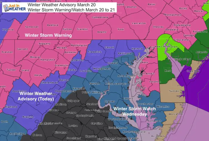
There is a Winter Weather Advisory in effect for the colder metro Baltimore area today. This includes: Harford, northern Baltimore, Carroll, western Howard/Montgomery, and Frederick Counties in Maryland. This is the area on the edge of snow with some stickage today. But most will be on the grass. The Winter Storm Warning is in effect for Southern Pennsylvania to the mountains of western Maryland today. The Eastern Shore kicks in tonight and tomorrow. Central and southern Maryland is under a Winter Storm Watch, but that should be upgraded during the day today. See all of the maps below.
Stats For March 20
Average High: 55ºF
Record High: 85ºF in 1945
Average Low: 35ºF
Record Low: 12ºF in 1885
Snow Record: 4.1″ in 1965
Seasonal Snow To Date (at BWI): 10.5″
Sunrise: 7:09 AM
Sunset 7:18 PM
*Daylight = 2:35 longer than yesterday
*Bay Water Temperature = 42ºF at Thomas Pt. Light House
Keep In Touch Every Day
Click here to sign up for email alerts…. Just in case you don’t get the post on your social media feed
FITF Spring Sale: Due to the storm, all apparel is 20% off. Use Promo Code: springsnow
Today:
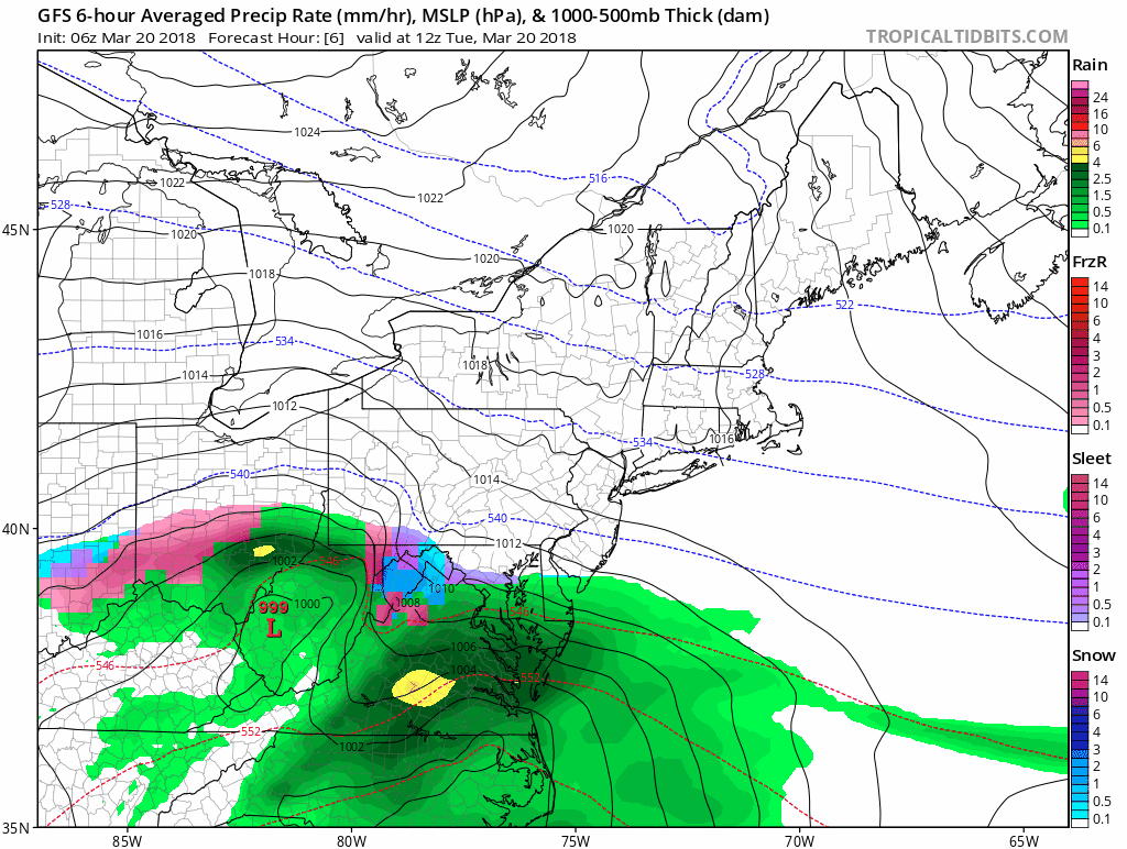
This storm is still in the formation stage. The energy feeding into it produced multiple tornadoes in Alabama and Florida Monday. The initial mix and snow will be in the mountains. Locally our mix with snow and sleet still falls on warmer roads. So wet pavement even as it gradually change to snow. The real issue will be the evening and tonight into Wednesday.
Update at 9 AM
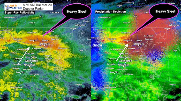
8:56 AM Doppler Radar showed the intensity as heavy sleet on the front edge of this system was enough to overtake the warm ground. I have reports from Frederick to Mt Airy, and Owings Mills. I told my clients it will ease there between 9:10 and 9:20 AM.
This is moving north and should last less than 1 hour if you are in it.
There will be snow or mix most of the day…
But after 10 SM we should get help from the higher sun angle to keep roads wet.
Also See:
Winter Precipitation Types. What is sleet?
Spring Sun Angle and Late March Daily Snow Records

There will be rain and snow building in this morning. It will transit to more snow and sleet in the colder Advisory areas. But roads should remain wet until 6 PM. See the temperatures below the slider. There may be snow travel issues west of Hagerstown
Part 1 Of Storm: Radar Simulation HRRR Model—> slider
[metaslider id=60409]
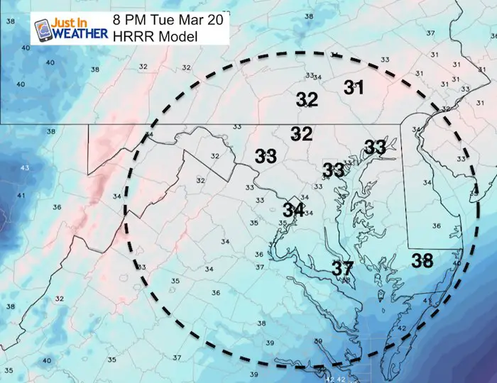
Temperatures
The freezing air will be hard to find. We will be getting snow and sleet from much colder clouds and a sign up the strength of the two part storm.
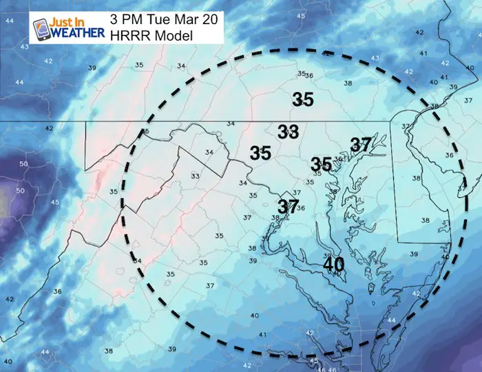
This Evening Freezing Temps reach northwest suburbs
Full Storm Animation: GFS Model
Part 2 Wednesday: Radar Simulation NAM 3 Km Model —> slider
[metaslider id=60442]
My Call For Snowfall
The map is the same, but totals increased just a little from my initial forecast. There will be more on the grass than the roads.
Our biggest impact time will be Wednesday morning to noon. Icing expected Thursday morning after the storm departs
I labeled this with letters to give each zone a description below. The + is the upside potential. That depends on how much can stick on Wednesday during the day. I went lower out of caution.
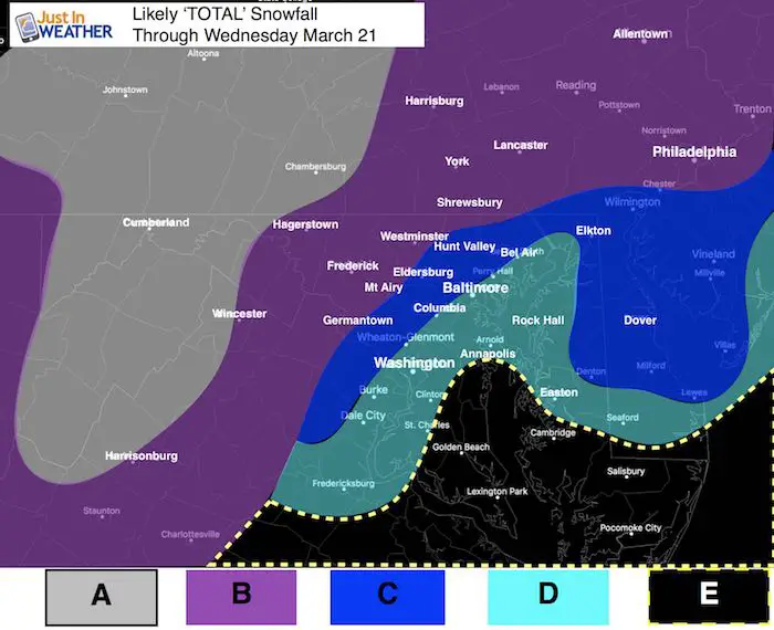
A: 12 to 20 inches. Mostly Snow! Elevation will help stickage
B: 6 to 12 inches. (Tuesday part will be 1 to 3 inches) Mostly snow or mix, but melting during the day. Road issues after 6 PM Tuesday into Wednesday. Snow during the day will add up a little. + Upside potential depends on how much can stick during the day. Icing up overnight into Thursday morning.
C: 5 to 10 inches. The ground will be warmer so it will take longer to get stickage. Most accumulation of this amount of snow will be before 10 AM Wednesday. Snow during the day will be tough to accumulate. If it sticks during the day, amounts will be high +. Icing up overnight into Thursday morning.
D: 3 to 6 inches. There will be snow here Wednesday. It will snow most of the day, but battle the sun and warm influence from the Bay. More snow will fall than can stick. There will be icing up by Thursday morning.
E: Slushy 2 to 4 inches. This area will get snow most of Wednesday but most will stick on the grass. Might get Wednesday evening snow and possible freezing of ground into Thursday morning.
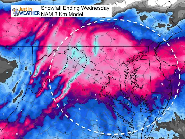
Snowfall from NAM 3 Km
This is why there is so much hype. Numbers like this would be more realistic in January. But a lot will be lost to melting and compacting. Especially where temps remain near or above freezing to the south
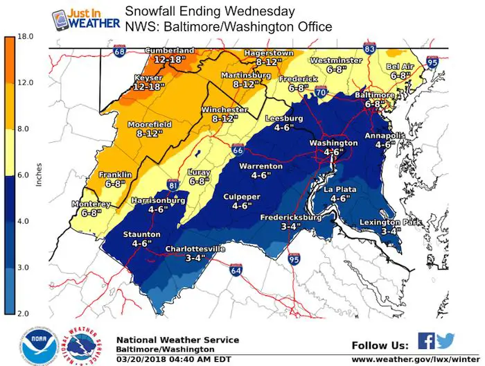
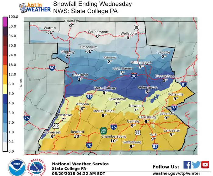
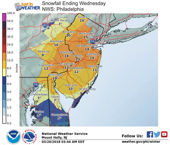
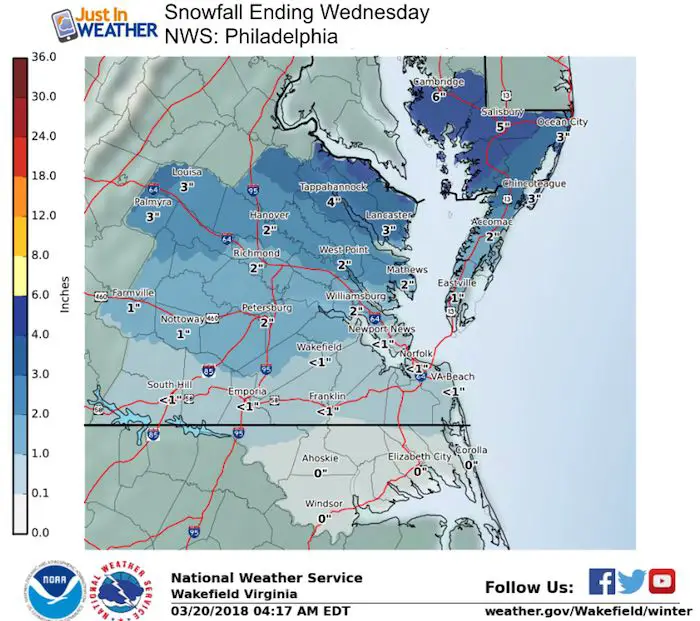
Snowfall from National Weather Service Regional Offices
Keep In Touch Every Day
Click here to sign up for email alerts…. Just in case you don’t get the post on your social media feed
Please share your thoughts, best weather pics/video, or just keep in touch via social media
-
Facebook: Justin Berk, Meteorologist
-
Twitter: @JustinWeather
-
Instagram: justinweather
FITF Items Now On Sale (again)
To celebrate this rare late March Storm everything is 20% off. Use promo code: springsnow

Snowstix- We Need You To Measure Snow Too
We are giving 10% of each sale to programs that benefit pediatric oncology patients.

 Get the award winning Kid Weather App I made with my oldest son and support our love for science, weather, and technology. Our 3 year anniversary of the release and our contribution to STEM education is this November. It has been downloaded in 60 countries, and works in both temperature scales. With your support we can expand on the fun introduction to science and real weather.
Keep In Touch Via Email
Click here to sign up for email alerts…. Just in case you don’t get the post on your social media feed
Also See:
My Winter Outlook 2017-2018 for more snow
La Nina Formed: What it could mean to our winter
NOAA Winter Outlook: Not The Best But Not The Worst For Snow
Two Farmers Almanacs Winter 2018 Outlooks
Winter Weather Folkore: Suggestions from Animals and Crops
First Frost and Freeze Dates For Maryland (southern PA and northern VA)
My Preliminary Winter Outlook Notes
Low Snow Winters In Baltimore: To Repeat Or Not Repeat
NOAA Ranks Blizzard 2016 4th Worst Snowstorm On Record
Blizzard 2016 Record Top Snowstorm: Area Totals
Extreme Weather of 2015 balanced out on both ends