 March 20 2018
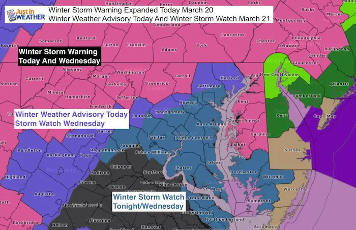
The Winter Storm Warning for today has been expended to include parts of central Maryland. Despite the Spring Equinox occurring at 12:15 PM, colder air and heavier snowfall simply over compensated for any ground warming. Now that we have a layer of snow and colder air, there is more stickage. This may beg the question of whether this storm will overachieve. In this post, I have the latest snowfall maps that include the highest snow potential if we get more snow to stick rather than melt.
The areas of expanded concern include Carroll, and Frederick Counties. I want to add the concern for northern Baltimore County as well. The Winter Weather Advisory remains for this areas and northern Harford County, as well as western Howard and Montgomery Counties.
Many of these school districts are closing early and the decision is a good idea since the colder air may lead to worse problems sooner than later in areas on the edge. My morning post with snow timeline sliders is here. I need to get my own kids home safely from school and then I will update again this afternoon.
Keep In Touch Every Day
Click here to sign up for email alerts…. Just in case you don’t get the post on your social media feed
FITF Spring Sale: Due to the storm, all apparel is 20% off. Use Promo Code: springsnow
Temperatures as of 11 AM
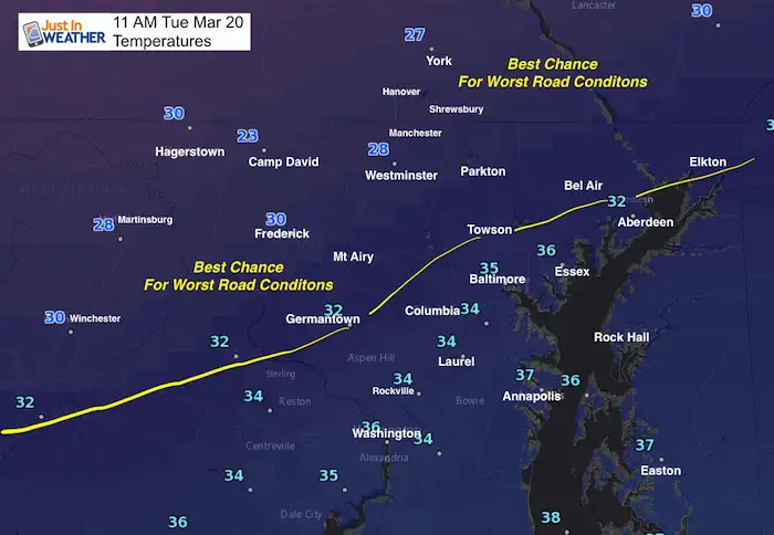
I want to point out that we expected temps to be just at the freezing line from Frederick to Westminster and York. Instead they are in the upper 20s to near 30ºF. That plus the heavier intensity of the snow has allowed for a layer of snow to overtake the warm ground. Now more snow can pile up. Snow intensity is key for areas to start getting stickage in the day. Warmer temps in metro Baltimore and south should hold off the road problems until later.
My Call For Snowfall
The map is the same, but totals increased just a little from my initial forecast. There will be more on the grass than the roads.
Our biggest impact time will be Wednesday morning to noon. Icing expected Thursday morning after the storm departs
I labeled this with letters to give each zone a description below. The + is the upside potential. That depends on how much can stick on Wednesday during the day. I went lower out of caution.
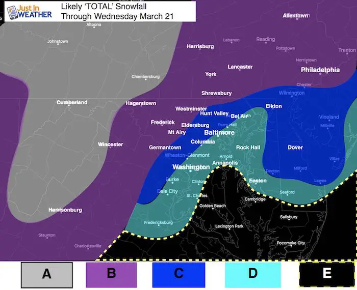
A: 12 to 20 inches. Mostly Snow! Elevation will help stickage
B: 6 to 12 inches. (Tuesday part will be 1 to 3 inches) Mostly snow or mix, but melting during the day. Road issues after 6 PM Tuesday into Wednesday. Snow during the day will add up a little. + Upside potential depends on how much can stick during the day. Icing up overnight into Thursday morning.
C: 5 to 10 inches. The ground will be warmer so it will take longer to get stickage. Most accumulation of this amount of snow will be before 10 AM Wednesday. Snow during the day will be tough to accumulate. If it sticks during the day, amounts will be high +. Icing up overnight into Thursday morning.
D: 3 to 6 inches. There will be snow here Wednesday. It will snow most of the day, but battle the sun and warm influence from the Bay. More snow will fall than can stick. There will be icing up by Thursday morning.
E: Slushy 2 to 4 inches. This area will get snow most of Wednesday but most will stick on the grass. Might get Wednesday evening snow and possible freezing of ground into Thursday morning.
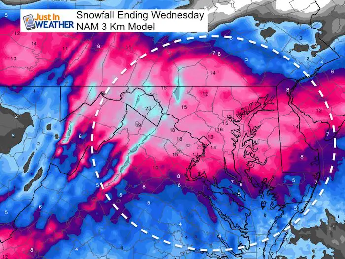
Snowfall from NAM 3 Km
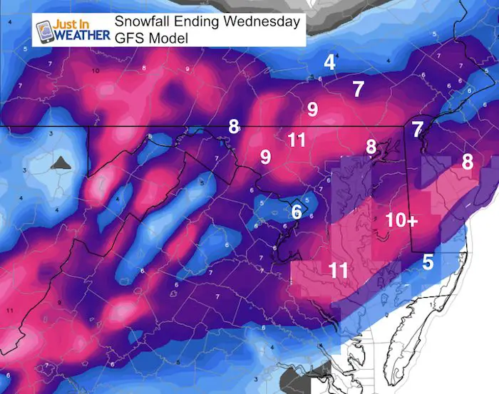
This is why there is so much hype. Numbers like this would be more realistic in January. But a lot will be lost to melting and compacting. Especially where temps remain near or above freezing to the south
Snowfall from NGFS Model
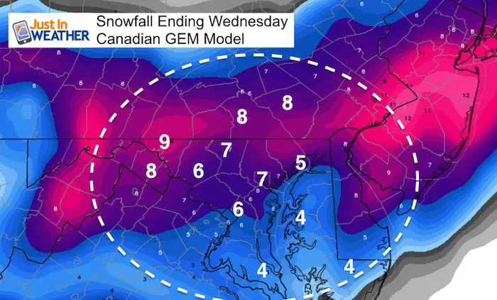
Snowfall from Canadian GEM
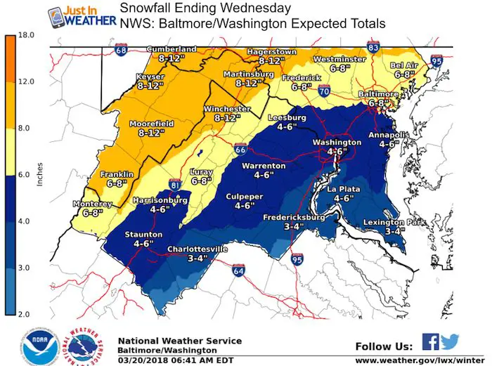
Snowfall from National Weather Service Regional Offices
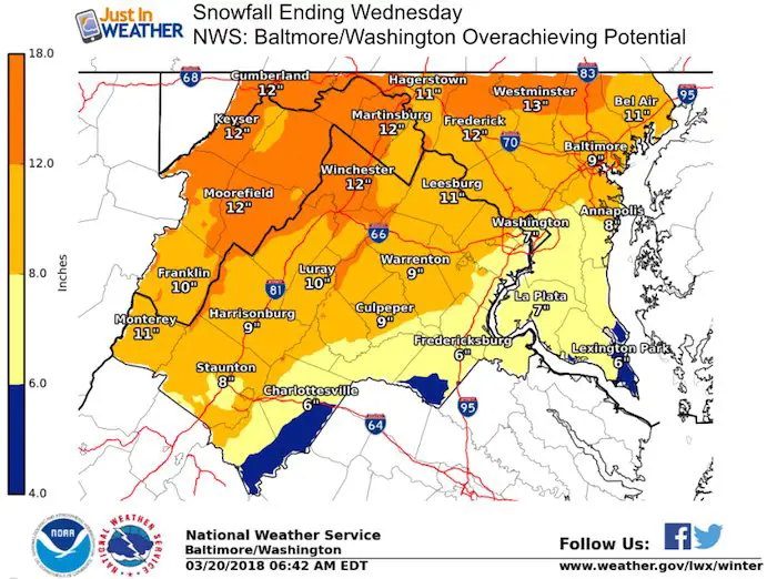
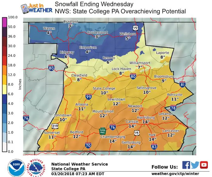
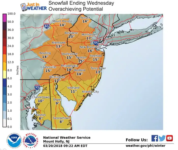
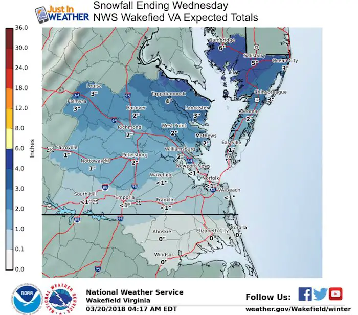
Expected Snowfall AND Overachieving Potential
I never show the worst case snow maps form NWS because I do not want to falsely lead with the high end numbers. But considering the start of this event, I figured it was worth showing what ‘could’ happen if the storm gives us it’s hardest punch.
Baltimore/Washington: Expected Snow Totals
Overachieving Snow Potential
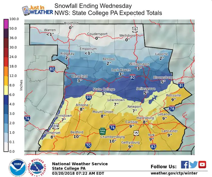
State College PA: Expected Snow Totals
Overachieving Snow Potential
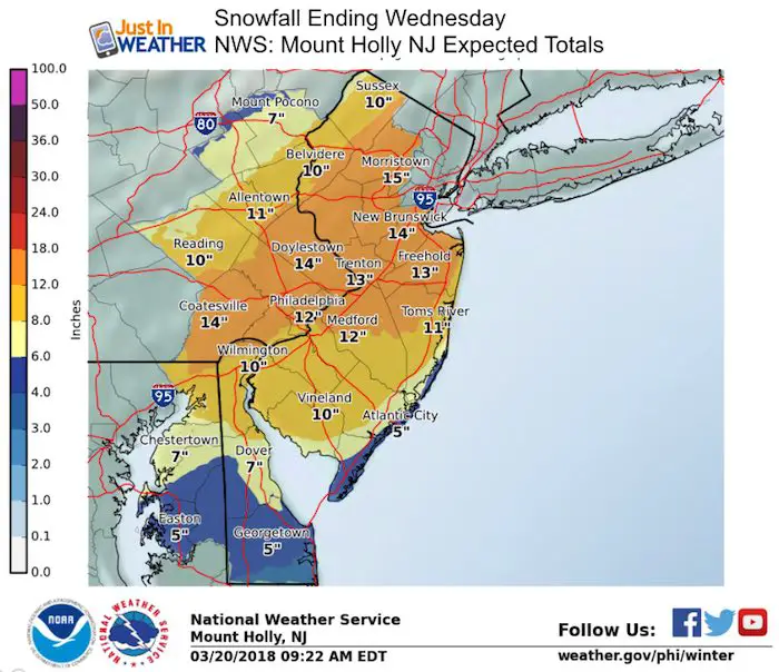
Mount Holly NJ: Expected Snow Totals
Overachieving Snow Potential
Wakefield VA: Expected Snow Totals
Overachieving Snow Potential 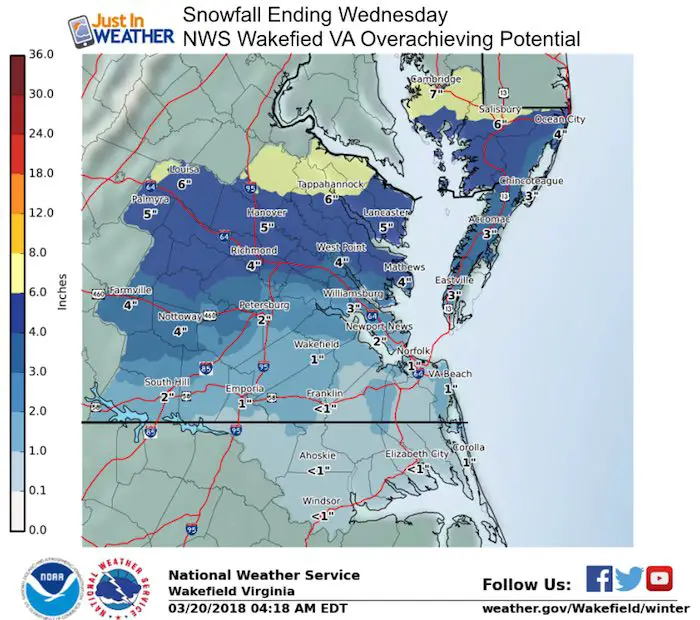
Also See:
Winter Precipitation Types. What is sleet?
Spring Sun Angle and Late March Daily Snow Records

Keep In Touch Every Day
Click here to sign up for email alerts…. Just in case you don’t get the post on your social media feed
Please share your thoughts, best weather pics/video, or just keep in touch via social media
-
Facebook: Justin Berk, Meteorologist
-
Twitter: @JustinWeather
-
Instagram: justinweather
FITF Items Now On Sale (again)
To celebrate this rare late March Storm everything is 20% off. Use promo code: springsnow

Snowstix- We Need You To Measure Snow Too
We are giving 10% of each sale to programs that benefit pediatric oncology patients.

 Get the award winning Kid Weather App I made with my oldest son and support our love for science, weather, and technology. Our 3 year anniversary of the release and our contribution to STEM education is this November. It has been downloaded in 60 countries, and works in both temperature scales. With your support we can expand on the fun introduction to science and real weather.
Keep In Touch Via Email
Click here to sign up for email alerts…. Just in case you don’t get the post on your social media feed
Also See:
My Winter Outlook 2017-2018 for more snow
La Nina Formed: What it could mean to our winter
NOAA Winter Outlook: Not The Best But Not The Worst For Snow
Two Farmers Almanacs Winter 2018 Outlooks
Winter Weather Folkore: Suggestions from Animals and Crops
First Frost and Freeze Dates For Maryland (southern PA and northern VA)
My Preliminary Winter Outlook Notes
Low Snow Winters In Baltimore: To Repeat Or Not Repeat
NOAA Ranks Blizzard 2016 4th Worst Snowstorm On Record
Blizzard 2016 Record Top Snowstorm: Area Totals
Extreme Weather of 2015 balanced out on both ends