 March 20 2018 Updated at 8 PM
If this was in January we would be looking at a top 10 record storm. This will still be the largest event in over 2 years since our all time top snow in January 2016. We are now getting the snow and icing to spread and many schools are making early calls to cancel Wednesday plans. We are in for an increase in snow overnight and most of Wednesday. Even during the day, snowfall rates of 1 to 2 inches per hour pile up faster than it can melt and diminish any solar impact. Northern areas today proved that this snow has beaten the sun. FITF
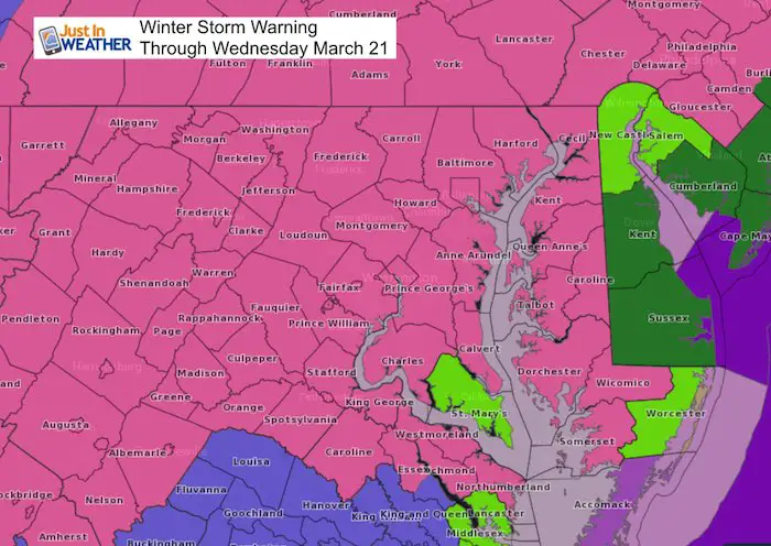
The Winter Storm Warning is in effect for most of Maryland, northern Virginia, and southern Pennsylvania. Today was a surprise for how heavy the snow rates were, which allowed it to overtake any ground warming and pile up. Many places in the all snow zone have between 6 to 8 inches of snow as of 6 PM. They are likely to at least double what is on the ground now! Temperatures will remain nearly steady or drop a degree or two overnight. In fact my updated snow map below is very similar to what you had seen earlier today. Except that is for additional snow through Wednesday. My updated additional snow and total snow numbers are below.
Wednesday morning will be rough traveling and the problems will expand to southern Maryland and Delmarva. Wind issues will be a problem on Delmarva close to multiple developing Low Pressure Centers. We will have a second storm developing and expanding from Washington to Baltimore between 3 and 6 AM. Heavy snow will be with us most of Wednesday. If this was January we could end up with a top 10 snow total. But we still must consider the heavy snow compacting and the sun angle playing a role.
Below is a look at the radar simulations, my updated snow map, and other snow forecasts.
Keep In Touch Every Day
Click here to sign up for email alerts…. Just in case you don’t get the post on your social media feed
FITF Spring Sale: Due to the storm, all apparel is 20% off. Use Promo Code: springsnow. Shop Here
Storm Set Up
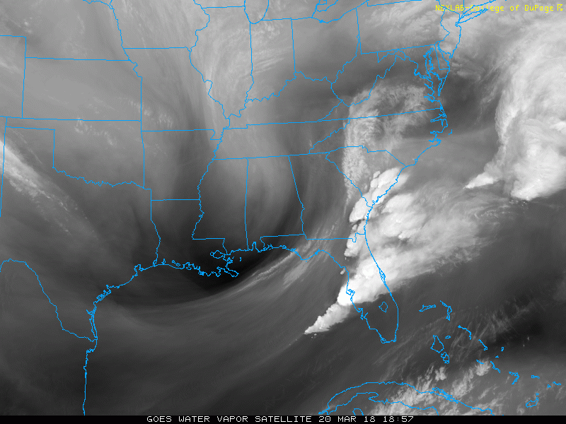
Water Vapor Satellite: 4 Hour Loop Ending at 6 PM Tuesday
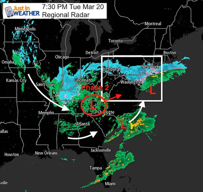
The parent Low is circulating between eastern TN and western NC. This is feeding the entire complex and will help the new Low form off of the coast. This will push in between 3 AM and 6 AM.
Evening Radar
The next coastal Low forming off of South Carolina is being fed by the energy form the severe storms of the past two days. There may be a few Low Pressure centers forming off of the Delmarva coast Wednesday and throw back Atlantic moist into the parent Low.
Watch Part 2 Arrive
Radar Simulation —> slider
Midnight to 11 AM Wednesday
The second phase of this storm will arrive from the south. It should reach Washington around 3 AM and Baltimore by 6 AM. Then heavy snow spreads east.
[metaslider id=60524]
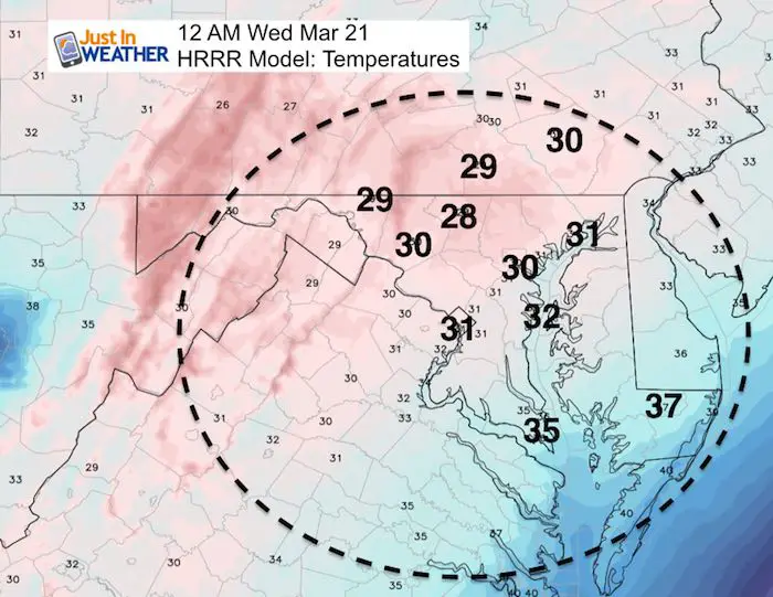
Temperatures at Midnight
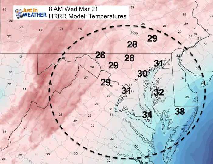
Temperatures at 8 AM
The freezing line will be through I-95. So even if you are still seeing a sleet mix, it should be icy on untreated ground.
NAM 3 Km Model: Wednesday Snapshots
—> slider shows 8 AM , Noon, 4 PM, and Midnight
Watch the heavy snow (deep blue) and sleet (pink) shift east. Snow will be heavy in the afternoon and move out overnight.
[metaslider id=60515]
My Call For Snowfall
The map is the same, but totals increased just a little from my initial forecast. There are two numbers. The Additional Snowfall from Tuesday evening through Wednesday AND the FINAL TOTAL.
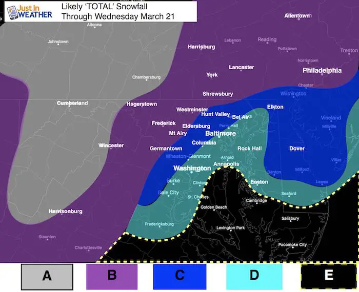
A: 12 to 20 inches total
B: 6 to 12 inches Additional Snow. TOTAL SNOW: 12 to 20 inches
Yes, many parts of this region already had 4 to 8 inches as of Tuesday evening. That was the overachiever. The rest is what close to what I originally expect to start adding up from this point forward.
C: 6 to 12 inches Additional Snow. TOTAL SNOW 8 to 14 inches
D: 4 to 8 inches TOTAL *If I bust here, it will be because I am too low. I am banking on snow compacting and melting here.
E: Slushy 3 to 6 inches. Snow will be expanding during the day and into Wednesday night on the Eastern Shore. The daytime snow will battle temps in the mid 30s and sun angle. If there are heavier rates of snow, that could compensate the melting and go higher.
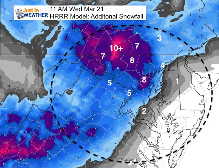
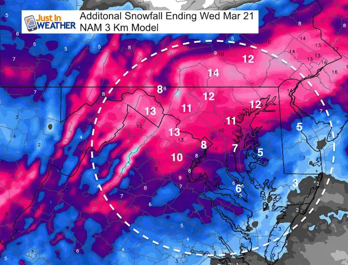
Model Forecasts For ADDITIONAL SNOW
This is computer guidance and I am still staying a little conservative. At this point, all bets are off!
HRRR MODEL
ONLY UP TO 11 AM
NAM 3 Km MODEL
Thursday Morning Icing
Temperatures should drop into the 20s Thursday morning so expect this impact to continue after the storm departs.
Also See:
Winter Precipitation Types. What is sleet?
Spring Sun Angle and Late March Daily Snow Records

Keep In Touch Every Day
Click here to sign up for email alerts…. Just in case you don’t get the post on your social media feed
Please share your thoughts, best weather pics/video, or just keep in touch via social media
-
Facebook: Justin Berk, Meteorologist
-
Twitter: @JustinWeather
-
Instagram: justinweather
FITF Items Now On Sale (again)
To celebrate this rare late March Storm everything is 20% off. Use promo code: springsnow

Snowstix- We Need You To Measure Snow Too
We are giving 10% of each sale to programs that benefit pediatric oncology patients.

 Get the award winning Kid Weather App I made with my oldest son and support our love for science, weather, and technology. Our 3 year anniversary of the release and our contribution to STEM education is this November. It has been downloaded in 60 countries, and works in both temperature scales. With your support we can expand on the fun introduction to science and real weather.
Keep In Touch Via Email
Click here to sign up for email alerts…. Just in case you don’t get the post on your social media feed
Also See:
My Winter Outlook 2017-2018 for more snow
La Nina Formed: What it could mean to our winter
NOAA Winter Outlook: Not The Best But Not The Worst For Snow
Two Farmers Almanacs Winter 2018 Outlooks
Winter Weather Folkore: Suggestions from Animals and Crops
First Frost and Freeze Dates For Maryland (southern PA and northern VA)
My Preliminary Winter Outlook Notes
Low Snow Winters In Baltimore: To Repeat Or Not Repeat
NOAA Ranks Blizzard 2016 4th Worst Snowstorm On Record
Blizzard 2016 Record Top Snowstorm: Area Totals
Extreme Weather of 2015 balanced out on both ends