 Friday March 16 2018 6:20 AM
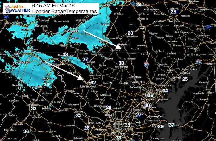
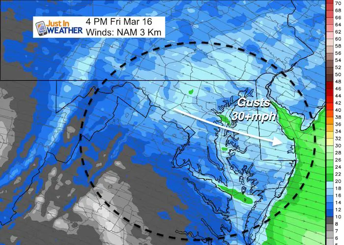
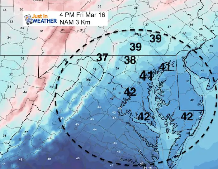
There are some flurries on Doppler Radar as another push of strong winds is holding the cold air in place. High temperatures today are more typical of January and will be joined by wind gusts over 30 mph. The wind should ease over the weekend for St. Patricks Day, but if you want to talk luck of the Irish… Snowshoe, WV has had 68 inches of snow in 8 days. The epic March has at least one more Nor’easter up its sleeve. Now that we are within 4 days event we have a better handle on how this may develop. There are still some details left to be sorted out, but plan for messy wintry mix across the region Tuesday and Wednesday. See the latest below.
Stats For March 16
Average High: 54ºF
Record High: 85ºF in 1945
Average Low: 33ºF
Record Low: 14ºF in 1911
Snow Record: 5.1″ in 1960
Seasonal Snow To Date (at BWI): 10.5″
Sunrise: 7:16 AM
Sunset 7:14 PM
*Daylight = 2:35 longer than yesterday
*Bay Water Temperature = 41ºF at Thomas Pt. Light House
Keep In Touch Every Day
Click here to sign up for email alerts…. Just in case you don’t get the post on your social media feed
Today:
Winds
High Temperatures
Thanks to the winds it will feel like the upper 20s to lower 30s
Saturday Showers
There will be a band of light snow/rain riding a jet streak into central Maryland. At this time it looks like it will miss southern PA, but metro areas could get a little damp during the day.
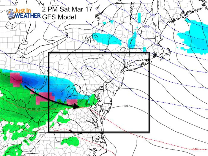
Storm Contrast (Tuesday/Wednesday)
See the animations below
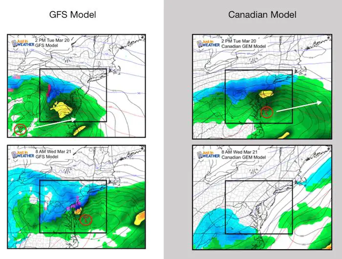
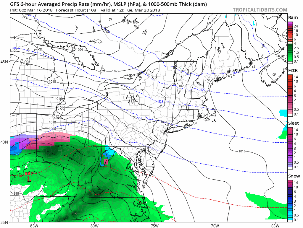
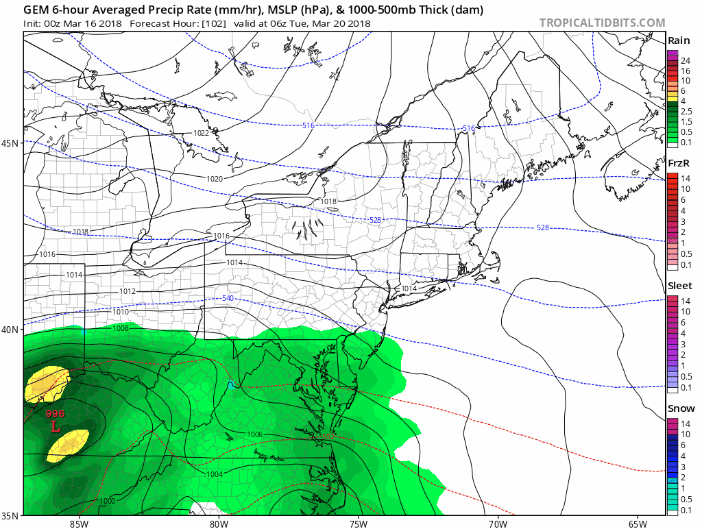
Here are the GFS and Canadian Models for comparison. These are the two I locked in on to show all week. Please keep in mind, to get accumulations in March, we need snow to fall overnight, or be very heavy during the day to battle the stronger March sun.
These both now show rain moving in Tuesday with snow in the colder northern suburbs. Let’s leave it at that for simplicity now. We can fine tune the snow line as we get closer. Snow will spread across central Maryland Tuesday night. But
GFS: Slows the transfer of energy to the coast until Wednesday. This results in more snow.
Canadian: Faster jump to the coast on Tuesday, so the storm departs faster by Wednesday morning.
The European Model not shown here shows an all out snow event for all of central Mayland and north. That includes very high snow totals. I can not support that solution at this time.
Note: I WILL NOT show snow forecast maps until within 72 hours of an event. That will be this weekend when I being. I show my snow forecasts starting 48 hours from the event. That is when there is more confidence and less likely to waver back and forth.
Storm Animations
GFS
Canadian
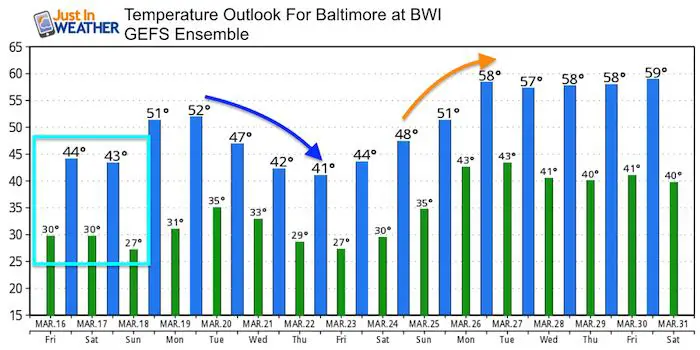
Temperature Outlook
Please share your thoughts, best weather pics/video, or just keep in touch via social media
-
Facebook: Justin Berk, Meteorologist
-
Twitter: @JustinWeather
-
Instagram: justinweather
Keep In Touch Every Day
Click here to sign up for email alerts…. Just in case you don’t get the post on your social media feed
FITF Items Will Close At The End Of This Week For The Season
It’s almost time for spring and a new line of items.

Snowstix- We Need You To Measure Snow Too
We are giving 10% of each sale to programs that benefit pediatric oncology patients.

 Get the award winning Kid Weather App I made with my oldest son and support our love for science, weather, and technology. Our 3 year anniversary of the release and our contribution to STEM education is this November. It has been downloaded in 60 countries, and works in both temperature scales. With your support we can expand on the fun introduction to science and real weather.
Keep In Touch Via Email
Click here to sign up for email alerts…. Just in case you don’t get the post on your social media feed
Also See:
My Winter Outlook 2017-2018 for more snow
La Nina Formed: What it could mean to our winter
NOAA Winter Outlook: Not The Best But Not The Worst For Snow
Two Farmers Almanacs Winter 2018 Outlooks
Winter Weather Folkore: Suggestions from Animals and Crops
First Frost and Freeze Dates For Maryland (southern PA and northern VA)
My Preliminary Winter Outlook Notes
Low Snow Winters In Baltimore: To Repeat Or Not Repeat
NOAA Ranks Blizzard 2016 4th Worst Snowstorm On Record