Friday March 16 2018
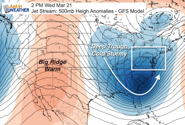
This updated outlook for the 4th consecutive Nor’easter expected on March 20 and 21 is purely to show the latest modeling. I have been reluctant to do much more as there is still some uncertainty with both the timing and tracking of the snow/rain line. But today there is more support for the wintry side of things. There will be a strong storm and it will impact the Mid Atlantic! This upper air set up next week is a dream come true if you want an east coast storm. It will feature a very deep trough to our south and a high amplitude jet stream. If this was January we would be in storm for an impressive event. But, this will be at the start of Spring! We will have the storm, but the impact is still questionable. Just plan for a sloppy Tuesday and Wednesday. Yes, that means the wind machine kicks up again too.
The time if year adds another element that needs to be considered. It is tough in late March to get accumulating snow on the roads during the day. It is possible, especially in the morning or evening. But the higher sun angle limits day time impact unless there is heavy snow and cold temperatures.
I will NOT show any snow potential maps until we are with 72 hours of the event. This weekend, when the timing and track take better form, is when I will start showing snow maps on my posts. If you see or hear of any snow amounts please consider:
- We need to know the surface temperatures
- Snow ratios are likely to be lower than the standard 10:1. That means a wet, slushy snow that compacts a lot instead of fluffing up (like when its colder)
- Snow is less likely to stick or accumulate much during the daylight in late March.
- Most accumulation tends to occur at night.
Comping Computer Models
See the animations below. I slowed them down to view them easier.
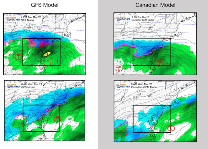
The GFS starts farther north and warmer, but has a slow development of the coastal energy and lingers snow longer. It does pull the snow through central Maryland through all of Wednesday. The Canadian is faster and farther north. This brigs snow into more of our region sooner on Tuesday, but then kicks the storm out of here Wednesday morning.
Storm Animations
GFS- Tuesday morning to Thursday
This tracks farther north and keeps the freezing line in the northern suborns near and north of the Pennsylvania line. The set up here is the transfer of energy to the coast with a slower development. It appears as a staled front with multiple waves of Low Pressure forming off of the Delmarva coast before sunrise on Wednesday and again Wednesday evening.
The European Model (not shown here) continues to show this as an all snow event. Event though that model has a better history of accuracy, we can not trust the snow totals due to timing, compaction, and melting. I promise to give more details this weekend.

Canadian GEM Tuesday Morning To Wednesday Evening
This model looks colder with the initial event tracking farther south. Then it moves off of the coast. This shows snow all day Tuesday into Wednesday afternoon. But that will not all be sticking.
Please share your thoughts, best weather pics/video, or just keep in touch via social media
-
Facebook: Justin Berk, Meteorologist
-
Twitter: @JustinWeather
-
Instagram: justinweather
Keep In Touch Every Day
Click here to sign up for email alerts…. Just in case you don’t get the post on your social media feed
FITF Items Will Close At The End Of This Week For The Season
It’s almost time for spring and a new line of items.

Snowstix- We Need You To Measure Snow Too
We are giving 10% of each sale to programs that benefit pediatric oncology patients.

 Get the award winning Kid Weather App I made with my oldest son and support our love for science, weather, and technology. Our 3 year anniversary of the release and our contribution to STEM education is this November. It has been downloaded in 60 countries, and works in both temperature scales. With your support we can expand on the fun introduction to science and real weather.
Keep In Touch Via Email
Click here to sign up for email alerts…. Just in case you don’t get the post on your social media feed
Also See:
My Winter Outlook 2017-2018 for more snow
La Nina Formed: What it could mean to our winter
NOAA Winter Outlook: Not The Best But Not The Worst For Snow
Two Farmers Almanacs Winter 2018 Outlooks
Winter Weather Folkore: Suggestions from Animals and Crops
First Frost and Freeze Dates For Maryland (southern PA and northern VA)
My Preliminary Winter Outlook Notes
Low Snow Winters In Baltimore: To Repeat Or Not Repeat
NOAA Ranks Blizzard 2016 4th Worst Snowstorm On Record