 Thursday March 15 2018
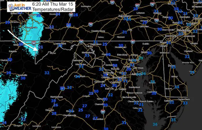
Beware the ides of March… The wind will be less intense today and temperatures will be close to average. But we are still under the influence of that large departing storm producing showers off of the Great Lakes. Garrett County could pick up a few more inches of powder, helping Wisp with some of their best conditions of the season. This will reach most of our region as rain, but some snow flakes mixed in on the north side this afternoon. It appears that this weekend will not be as warm as we had first hoped, but still an improvement with the wind machine will help make it feel better.
Next week will bring us a storm, but the impact is still unsure. The comparison of two commuter models below show the latest set up. I just hope you remember what app or person already gave you snow totals and shake your head. There is no possible way to know that this early when the track and snow/rain line are still quite uncertain.
Stats For March 15
Average High: 53ºF
Record High: 82ºF in 1990
Average Low: 33ºF
Record Low: 10ºF in 1993
Snow Record: 5.0″ in 1896
Seasonal Snow To Date (at BWI): 10.5″
Sunrise: 7:17 AM
Sunset 7:13 PM
*Daylight = 2:35 longer than yesterday
*Bay Water Temperature = 41ºF at Thomas Pt. Light House
Keep In Touch Every Day
Click here to sign up for email alerts…. Just in case you don’t get the post on your social media feed
Rain Showers Timeline –> slider
[metaslider id=60195]
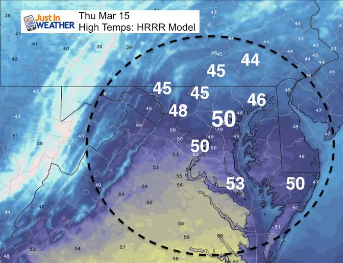
High Temperatures
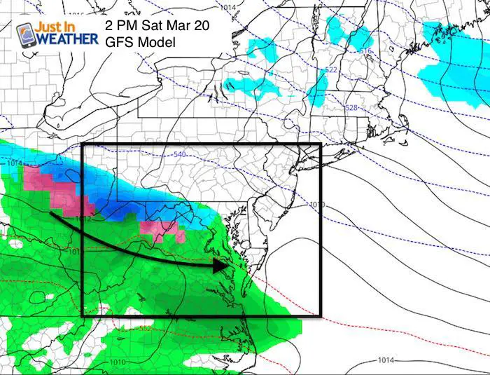
Weekend Highlight
Saturday could bring a light mix of snow/rain with this system racing across the mountains. It looks light at this time. Sunday will be the better day of the weekend.
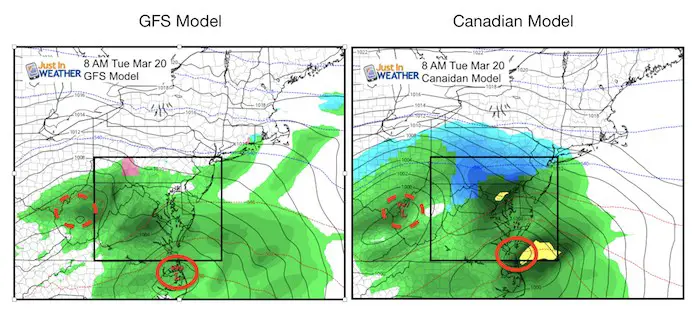
About That Storm Next Week…
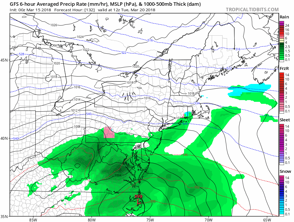
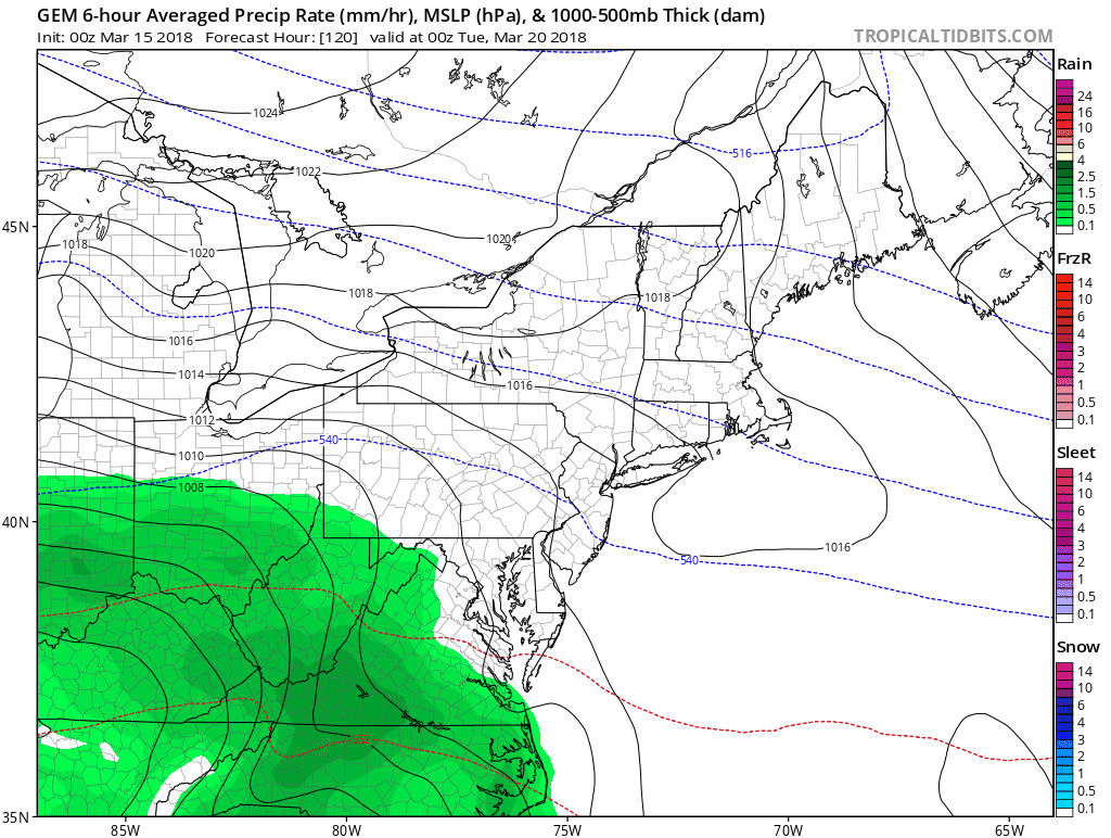
There will be a Nor’easter but the development is not promising a winter impact. Once again we have diverging prospects on the modeling. Here is a look at just two major global models… And look at the snow on the Canadian just north into southern PA. The GFS looks warmer…
See the animations below that show that there are snow showers to follow on Wednesday (with this latest model run). I am sure this will change again…
Storm Animations
GFS Model
Canadian Model
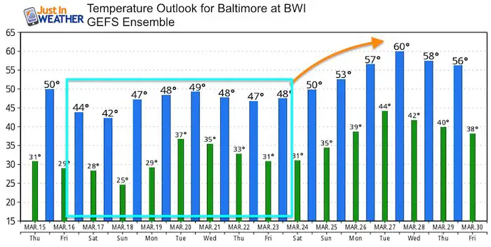
Temperature Outlook
The warm up for Sunday is now uneventful as the upper level pattern is holding us cooler. But we should shake the chill next week. After that storm passes by…
Please share your thoughts, best weather pics/video, or just keep in touch via social media
-
Facebook: Justin Berk, Meteorologist
-
Twitter: @JustinWeather
-
Instagram: justinweather
Keep In Touch Every Day
Click here to sign up for email alerts…. Just in case you don’t get the post on your social media feed
FITF Items Will Close At The End Of This Week For The Season
It’s almost time for spring and a new line of items.

Snowstix- We Need You To Measure Snow Too
We are giving 10% of each sale to programs that benefit pediatric oncology patients.

 Get the award winning Kid Weather App I made with my oldest son and support our love for science, weather, and technology. Our 3 year anniversary of the release and our contribution to STEM education is this November. It has been downloaded in 60 countries, and works in both temperature scales. With your support we can expand on the fun introduction to science and real weather.
Keep In Touch Via Email
Click here to sign up for email alerts…. Just in case you don’t get the post on your social media feed
Also See:
My Winter Outlook 2017-2018 for more snow
La Nina Formed: What it could mean to our winter
NOAA Winter Outlook: Not The Best But Not The Worst For Snow
Two Farmers Almanacs Winter 2018 Outlooks
Winter Weather Folkore: Suggestions from Animals and Crops
First Frost and Freeze Dates For Maryland (southern PA and northern VA)
My Preliminary Winter Outlook Notes
Low Snow Winters In Baltimore: To Repeat Or Not Repeat
NOAA Ranks Blizzard 2016 4th Worst Snowstorm On Record