6:20 AM Friday March 9 2018
We are in a colder pattern that will last into next week. There is still the concern of a strong storm along the coast with disagreement of computer model guidance. But what will follow by next weekend will be a legitimate warm up. Here is a quick look at round up for today and outlook for the potential storm Sunday and Monday. There is still only on model showing a strong impact with snow but it is worth watching.
Reminder that Daylight Saving Time begins this weekend. Turn your clocks ahead (1 Hour at 2 AM Sunday). We will lose 1 hour of sleep. But while the morning set dark again, evening light will be noticeable with sunset in the 7 PM hour. By this time next week it will feel like spring for sure.
Stats For March 9
Average High: 51ºF
Record High: 82ºF in 2016
Average Low: 31ºF
Record Low: 10ºF in 1960
Snow Record: 7.8″ in 1976
Seasonal Snow To Date (at BWI): 10.5″
Sunrise: 6:27 AM
Sunset 6:07 PM
*Daylight = 2:34 longer than yesterday
*Bay Water Temperature = 40ºF at Thomas Pt. Light House
Keep In Touch Every Day
Click here to sign up for email alerts…. Just in case you don’t get the post on your social media feed
This Morning
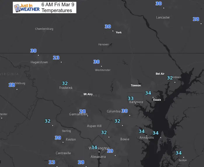
This Afternoon
Wind gusts over 20 mph will make it feel like the 20s and 30s. There will be building clouds and maybe some flurries in the northwest hills.
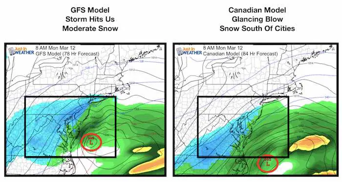
Storm Hit or Miss
The GFS Model remains the only global model showing this storm as a hit for us with moderate snow Monday morning. The Canadian is closer but still keep most snow in southern Maryland and Eastern Shore. The European is still a complete miss. See the animation of these models below.
Computer Model Animations
The timing of the energy now results in the storm moving off the coast instead of up the coast. But the track still plays right on the edge of our region. An adjustment of about 50 to 100 miles makes or breaks the snow for us.
GFS Model
Canadian GEM Model
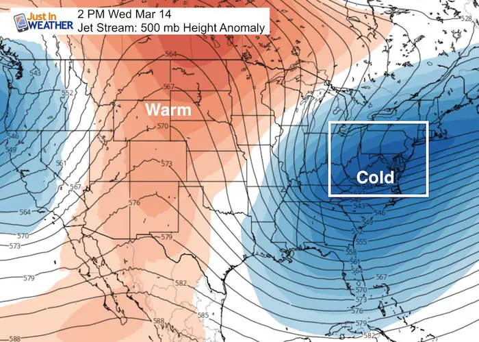
Jet Stream Next Week
Following the storm, regardless of a hit or miss… Will be colder air mid week. Then the big warm up in the central US will reach us next weekend.
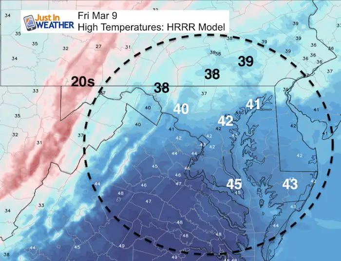
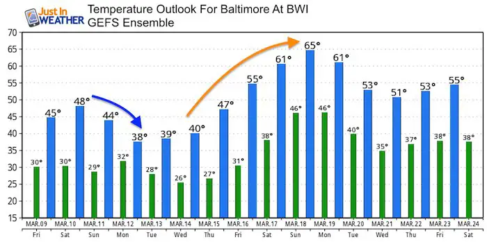
Temperature Outlook
Please share your thoughts, best weather pics/video, or just keep in touch via social media
-
Facebook: Justin Berk, Meteorologist
-
Twitter: @JustinWeather
-
Instagram: justinweather
Keep In Touch Every Day
Click here to sign up for email alerts…. Just in case you don’t get the post on your social media feed
FITF Items Will Close Next Week For The Season
It’s almost time for spring and a new line of items.

Snowstix- We Need You To Measure Snow Too
We are giving 10% of each sale to programs that benefit pediatric oncology patients.

 Get the award winning Kid Weather App I made with my oldest son and support our love for science, weather, and technology. Our 3 year anniversary of the release and our contribution to STEM education is this November. It has been downloaded in 60 countries, and works in both temperature scales. With your support we can expand on the fun introduction to science and real weather.
Keep In Touch Via Email
Click here to sign up for email alerts…. Just in case you don’t get the post on your social media feed
Also See:
My Winter Outlook 2017-2018 for more snow
La Nina Formed: What it could mean to our winter
NOAA Winter Outlook: Not The Best But Not The Worst For Snow
Two Farmers Almanacs Winter 2018 Outlooks
Winter Weather Folkore: Suggestions from Animals and Crops
First Frost and Freeze Dates For Maryland (southern PA and northern VA)
My Preliminary Winter Outlook Notes
Low Snow Winters In Baltimore: To Repeat Or Not Repeat
NOAA Ranks Blizzard 2016 4th Worst Snowstorm On Record