9:55 PM Thursday March 8 2018
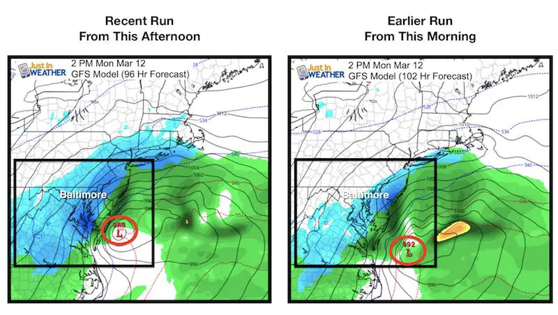
I didn’t really want to write about this storm yet, but I understand the excitement or concern. I need to warn you that the GFS Model is the only one of the major global models showing this storm as a hit for us Sunday night and Monday. It flip flops more than when my prom date was deciding on which dress to wear. I am sorry Allison, but it was true and I was very patient. Well, patience is a virtue that needs to be exercised again with this third Nor’easter. The GFS Model did show a shift (I remembered the F this time) closer in this afternoon’s run compared to this morning. This adjustment of 50 miles brings the heavy snow band across the Chesapeake Bay compared to the glancing blow from this morning.
I simply can NOT jump on to the notion of us getting hit at this time. The mere 50 mile push offshore in our last storm broke the forecast for our wester half of the area. It would be irresponsible to try to suggest with confidence that we get this while were are still on the edge, 4 days away. There will be a storm that forms and it still deserves attention. But plans do not need to be changed at this time.
Here is the 2 PM Monday time frame to compare. See both animated storm tracks below. *The new/evening model runs will be arriving shorty after this post. Should there be any big shifts, I will acknowledge them in my morning update.
GFS Model
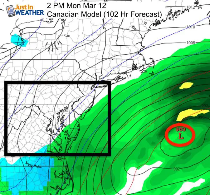
Canadian Model
The GFS Model updates every 6 hours. The Canadian Model I show below only has 12 hour update cycles and this morning’s run was much farther offshore. This is inline with the European Model. The other 6 Hr update model is the NAM 12 Km and it has the same 18Z (1 PM EDT) time update to compare. It is NOT even close to us. I posted that below with the other animations. So please consider this as you see the contrast and read other blogs. It is easy to find the model you want that shows the best solution for snow, but that is not necessarily the one that will play out.
Compare Storm Track Animations
GFS (recent afternoon run)
GFS (morning run)
Canadian (morning run)
NAM 12 Km (recent afternoon run)
Please share your thoughts, best weather pics/video, or just keep in touch via social media
-
Facebook: Justin Berk, Meteorologist
-
Twitter: @JustinWeather
-
Instagram: justinweather
Keep In Touch Every Day
Click here to sign up for email alerts…. Just in case you don’t get the post on your social media feed
FITF Sale
It’s almost time for spring and a new line of items. FITF will be closed for the season at the end of next week.

Snowstix- We Need You To Measure Snow Too
We are giving 10% of each sale to programs that benefit pediatric oncology patients.

 Get the award winning Kid Weather App I made with my oldest son and support our love for science, weather, and technology. Our 3 year anniversary of the release and our contribution to STEM education is this November. It has been downloaded in 60 countries, and works in both temperature scales. With your support we can expand on the fun introduction to science and real weather.
Keep In Touch All Winter
Click here to sign up for email alerts…. Just in case you don’t get the post on your social media feed
Also See:
My Winter Outlook 2017-2018 for more snow
La Nina Formed: What it could mean to our winter
NOAA Winter Outlook: Not The Best But Not The Worst For Snow
Two Farmers Almanacs Winter 2018 Outlooks
Winter Weather Folkore: Suggestions from Animals and Crops
First Frost and Freeze Dates For Maryland (southern PA and northern VA)
My Preliminary Winter Outlook Notes
Low Snow Winters In Baltimore: To Repeat Or Not Repeat
NOAA Ranks Blizzard 2016 4th Worst Snowstorm On Record