 March 8 2018
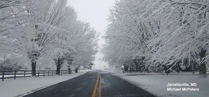
The late season Nor’easter that brought snow to our area was a complex event. It was talked up for days and this post is only to simplify the recap as to why some got more and others got less than expected. When a strong storm is talked up for days and you don’t get what was expected, it is easy to call this thing and my forecast a bust. But it wasn’t completely. Plus some areas got their snow and would have had more but the warmer ground melted it. This photo in Harfrod County from Michael McPeters highlights the warm pavement and wet roads that was expected.
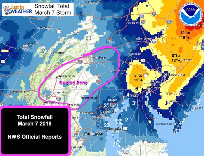
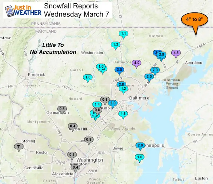
I am the first to highlight where my forecast was wrong, but this wasn’t entirely wrong. Baltimore’s BWI got 1.8″ of snow, now cracking into the 10 inch seasonal mark for the first time in two winters. Annapolis got 2 inches of snow, which was an over achiever. Metro areas did range between 2 to 3 inches, but the normally colder and snowier areas in the Winter Storm Warning did bust for sure with trouble reaching 1 inch in many areas in Carroll County and southern PA.
Please see the notes and maps below. Then feel free to comment or give me a grade on my forecast or role in your media consumption of this. Given the success AND failure regions you can compare below, I give myself a C – on this total forecast. Most of immediate metro Baltimore and on the east side got their storm and I hope were prepared. My kids were disappointed with 1 inch, but I was happy they didn’t miss another day of school (we have had plenty).
What went right with my forecast:
- A strong storm formed off of the east coast and phased with energy from the west.
- Snow developed Tuesday night into Wednesday morning for part 1
- The places that had snow accumulation got 1 to 3 inches by morning. I tried to stress this point since that would related to the morning travel and the areas that could get more accumulation during the day.
What Went Wrong
50 Miles East
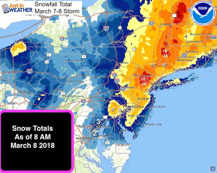
To understand the failure of this storm is pretty simple. The Low Pressure formed 50 miles to the east, shifting the snow that way. It also shifted the phasing a little later. The net result also brought Philadelphia and New York back into the heavy snow bands.
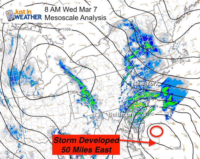
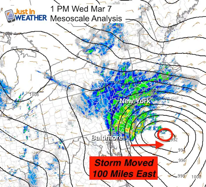
This map below shows the Low Pressure 100 miles offshore, when modeling plotted this right along the New Jersey coast.
The major failure for the low snow areas was the snow cover at daybreak. If there was snow on the ground, This cooled the surrounding areas and then more snow could accumulate on top of it. That is why roads are slushy.
But, the air and the ground was warmer than freezing. This is a point I made very clear in all of my updates. But, if there was little snow, then the warmer ground melted it before the sun angle got high and then the other snow bands could not do much. There was enough snow for a few more inches during the day, but it lost the chance to accumulate.
Snow Accumulation Total
- Heavier Snow fell on Northeast Maryland as expected
Wider View Of Totals Up to Metro New York
Compare My Maps To The Snow Reports
My first call was to point out the regions that wold get more northeast and less west. York and Lancaster were my biggest bust zones.
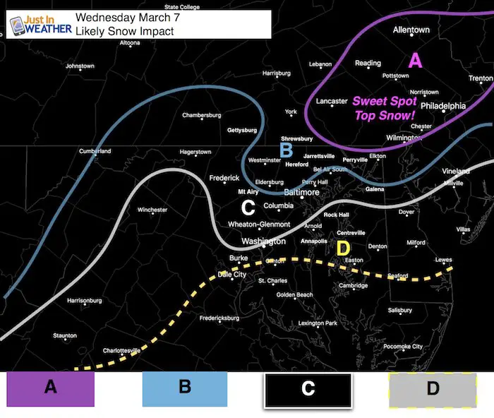
A: This is the Sweet Spot. This most snow will fall in eastern PA and may clip northern Cecil Co Maryland and northern Delaware.
B: Snow will fall overnight Tuesday and should have a cover on the ground Wednesday morning. A general 1 to 3+ inches is likely by morning, with upside potential based on how much can stick before daybreak to allow more to stick during the day.
C: Snow will mix in and change over Wednesday morning. It will snow during the day especially near Washington and east, but not stick on the roads. Roads should be wet. I-95 in Harford and Cecil county may be close to the stickage and melting line. It will be a tight gradient.
D: Snow will mix in here but little to no stickage is expected.
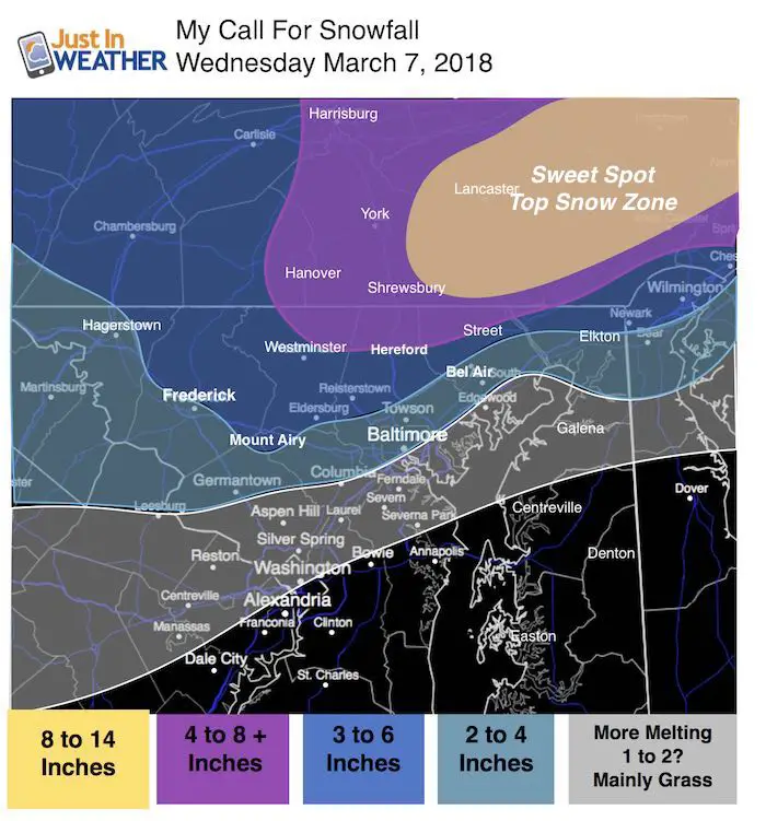
My Snow Map
*I had the wrong map in the original write up. I had posted the additional snowfall. This was my formal forecast map and yes, it clearly shows the busted areas. I am sorry for not having this sooner and for the poor forecast.
Shift this 50 miles east and most of it works out.
The biggest bust was Lancaster, York, northern Baltimore, Carroll, and Frederick Counties.
My 3 to 6 inch and 4 to 8 inch zones were a FAIL.
Metro 2 to 4 inch zone worked out around the beltway and east.
Baltimore and BWI was almost right on the money! Same with much of Harford and Cecil.
More snow than expected around Annapolis and northern Eastern Shore (Kent Co and Queen Annes Co).
The Local Snow Reports
These are limited this evening. Please check back for the updated storm total map later.
See the spotter reports below from Maryland and Delaware where up to 10 inches fell
********************STORM TOTAL SNOWFALL********************

LOCATION          STORM TOTAL     TIME/DATE   COMMENTS
                     SNOWFALL           OF
                     /INCHES/   MEASUREMENT

DISTRICT OF COLUMBIA

...District of Columbia...
   National Zoo 1 WSW     0.3   634 AM  3/07  Trained Spotter

MARYLAND

...Allegany County...
   Frostburg 2 ENE        1.5   915 AM  3/07  Trained Spotter

...Anne Arundel County...
   Annapolis 1 NW         2.0  1135 PM  3/06  Trained Spotter
   Bwi Airport            1.8   700 AM  3/07  Airport
   Mayo 2 NW              1.0  1101 PM  3/06  Trained Spotter

...Baltimore County...
   Long Green 2 NW        4.0   730 AM  3/07  Trained Spotter
   Brooklandville 2 NNW   3.0   915 AM  3/07  Trained Spotter
   Catonsville 1 SSE      2.0   756 AM  3/07  Trained Spotter
   Perry Hall 2 E         2.0  1011 AM  3/07  Trained Spotter
   Kingsville 1 E         2.0   632 AM  3/07  Trained Spotter
   Bentley Springs 5 SS   1.3   815 AM  3/07  Trained Spotter
   Bentley Springs 1 E    1.1   640 AM  3/07  Trained Spotter
   Reisterstown           1.0   630 AM  3/07  County Emrg Mgmt
   Glyndon 1 SW           1.0   709 AM  3/07  Trained Spotter

...Baltimore City...
   Pikesville 3 SE        2.8   635 AM  3/07  Trained Spotter
   Pimlico  SE            2.8   630 AM  3/07  Trained Spotter
   Arlington 2 ESE        1.2  1150 PM  3/06  Broadcast Media

...Carroll County...
   Eldersburg 1 SE        1.0   709 AM  3/07  Trained Spotter

...Harford County...
   Churchville 1 ESE      4.5  1200 PM  3/07  Dept of Highways
   Bynum 1 SW             3.3   705 AM  3/07  Trained Spotter
   Bel Air                2.8  1256 AM  3/07  County Emrg Mgmt
   Bel Air 1 NNE          2.8   634 AM  3/07  Trained Spotter

...Howard County...
   Columbia 2 N           1.4   635 AM  3/07  Trained Spotter
   Simpsonville 1 SSE     1.3  1200 AM  3/07  Trained Spotter
   Simpsonville  E        1.1   120 AM  3/07  Trained Spotter
   Simpsonville           1.1  1237 PM  3/07  Trained Spotter
   Columbia               0.8   513 AM  3/07  Broadcast Media
   Ellicott City 2 E      0.8   857 AM  3/07  Trained Spotter

...Montgomery County...
   Laytonsville           0.5   715 AM  3/07  County Emrg Mgmt
   Norbeck 1 ESE          0.4  1159 PM  3/06  Trained Spotter

...Prince Georges County...
   Beltsville 1 S         0.8  1205 AM  3/07  NWS Employee
..Cecil County...
   Rising Sun             5.5   310 PM  3/07  Trained Spotter
   5 NW Elkton            3.7   100 PM  3/07  Trained Spotter
DELAWARE

...Kent County...
   Smyrna                 2.7   356 PM  3/07  DEOS
   W Dover                1.9   357 PM  3/07  DEOS
   Woodside               1.3   358 PM  3/07  DEOS
   Dover                  0.8   358 PM  3/07  DEOS

...New Castle County...
   Greenville            10.4   348 PM  3/07  DEOS
   Brandywine            10.0   325 PM  3/07  Broadcast Media
   N Wilmington           8.0   245 PM  3/07  Social Media
   Smith Mill Farms       7.6   352 PM  3/07  DEOS
   Talley Brook           6.9   350 PM  3/07  DEOS
   Newark                 6.6   102 PM  3/07  CoCoRaHS
   Hockessin              6.0   350 PM  3/07  DEOS
   Edgemoor               6.0   155 PM  3/07  Social Media
   Prices Corner          5.7   350 PM  3/07  DEOS
   1 N Newark             5.6   233 PM  3/07  Trained Spotter
   New Castle County Ai   5.1   100 PM  3/07  ASOS
   New Castle             4.9   353 PM  3/07  DEOS
   Blackbird              4.2   354 PM  3/07  DEOS
   Claymont               4.2   348 PM  3/07  DEOS
   Glasgow                4.0   354 PM  3/07  DEOS
Please share your thoughts, best weather pics/video, or just keep in touch via social media
-
Facebook: Justin Berk, Meteorologist
-
Twitter: @JustinWeather
-
Instagram: justinweather
Keep In Touch Every Day
Click here to sign up for email alerts…. Just in case you don’t get the post on your social media feed
FITF Sale
To celebrate the late season snow storm, all FITF webstore apparel is now 20%. Use promo code: marchsnow now! Shop FITF

Snowstix- We Need You To Measure Snow Too
We are giving 10% of each sale to programs that benefit pediatric oncology patients.

 Get the award winning Kid Weather App I made with my oldest son and support our love for science, weather, and technology. Our 3 year anniversary of the release and our contribution to STEM education is this November. It has been downloaded in 60 countries, and works in both temperature scales. With your support we can expand on the fun introduction to science and real weather.
Keep In Touch All Winter
Click here to sign up for email alerts…. Just in case you don’t get the post on your social media feed
Also See:
My Winter Outlook 2017-2018 for more snow
La Nina Formed: What it could mean to our winter
NOAA Winter Outlook: Not The Best But Not The Worst For Snow
Two Farmers Almanacs Winter 2018 Outlooks
Winter Weather Folkore: Suggestions from Animals and Crops
First Frost and Freeze Dates For Maryland (southern PA and northern VA)
My Preliminary Winter Outlook Notes
Low Snow Winters In Baltimore: To Repeat Or Not Repeat
NOAA Ranks Blizzard 2016 4th Worst Snowstorm On Record