10 PM Tuesday March 6 2018
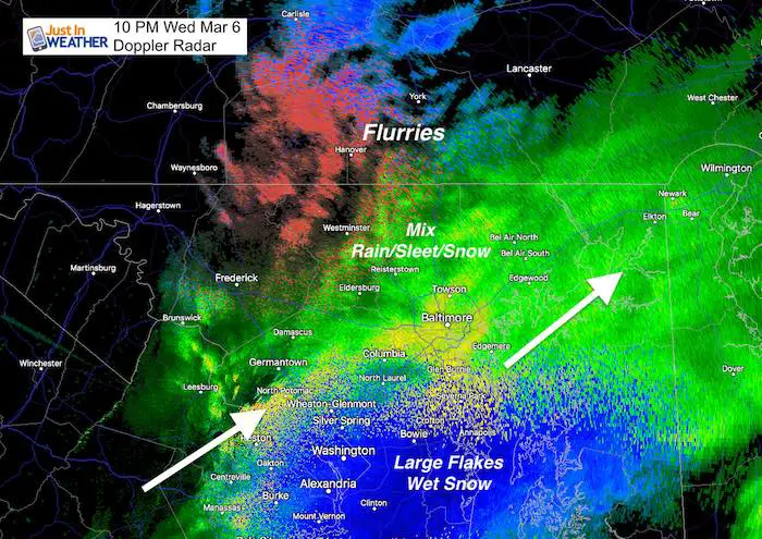
Doppler radar has shown the steady shield of snow and rain spreading across our area this evening and tonight. I understand the critics of this late season storm and in part I agree. It is March. It is warm and will stay above freezing. So how will any snow fall let along stick. Well, this storm is going to intensify rapidly and generate its own cold air. Then the moderate to heavy snow will drag it down towards the surface. Still, most of us stay above 32ºF, which means flakes will be wasted to melting.
But what this storm has going for it will be some moderate to heavy bands of snow at night that can cover before they melt, thus starting the accumulation process. The thing is that will NOT be the case for all of our region. It appears the classic ‘northwest’ colder areas that are in the Winter Weather Advisory or Winter Storm Warning will have the best chance. This is nothing new. It will be the metro areas around the Baltimore Beltway that will be the tough call. There is about a 20 mile buffer around I-95 for where the snow will stick or melt. Also consider that some of the energy may produce a rumble of thunder in the heavy snow zone and accelerate snowfall. That is why there is such a wide range for the north side.
Doppler Radar at 10 PM
The winter mode depiction is not perfect and has missed on some frozen precipitation earlier in the day, so this may need to be taken with a grain of salt. I am showing this at the 10 PM time frame to match up with the radar simulation slider below.
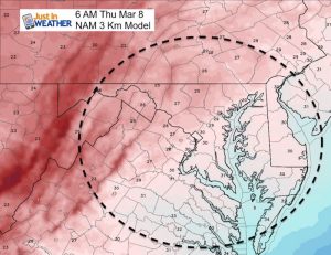
Below is the evening model run of the NAM 3 Km Model. If you missed my prior reports, this has been the most accurate model all winter. So while I hesitate with the higher snow option, I need to go with what has worked. Also, the GFS, Canadian, and European Models all increased their snow totals for our region in their last run.

Snow Simulation —> slider
- The NAM 3 Km model was showing rain in areas already getting snow. So the expanding snow is ahead of schedule and may help your area cool. *If you get stickage, it will be noticeable between midnight and 2 AM
- *Watch the phasing between 6 to 8 AM as the western energy feeds into the coastal storm and enhances the snow. See the notes below.
[metaslider id=59912]
Two parts of this storm:
- Overnight moderate snow. This will expand the snow southward after midnight. Places that get stickage could have 1 to 3 inches on the ground at daybreak. But within 10 to 20 miles of I-95 it may only stick on the grass.
- Moderate to heavy snow develops during the morning through noon, but will battle the sun angle for stickage and lose out eventually to warmer ground.
The snow line will be split across our area. This model is not perfect, so there is some wiggle room for adjustment. But it will be a tough call and there is bust potential on snow depending on stickage. Definitely more snow will lay and stay north and northeast of the city.
Click here to see the forecast snow maps and Warning/Advisory explanation
Re-Freeze Thursday Morning?
Reminder that temperatures are expected to drop after the storm. Places that have snow on the ground will be under the greatest chance to have icy roads. No snow areas should dry out before the cold air returns.
Please share your thoughts, best weather pics/video, or just keep in touch via social media
-
Facebook: Justin Berk, Meteorologist
-
Twitter: @JustinWeather
-
Instagram: justinweather
Keep In Touch Every Day
Click here to sign up for email alerts…. Just in case you don’t get the post on your social media feed
FITF Sale
To celebrate the late season snow storm, all FITF webstore apparel is now 20%. Use promo code: marchsnow now! Shop FITF
Snowstix- We Need You To Measure Snow Too
We are giving 10% of each sale to programs that benefit pediatric oncology patients.
 Get the award winning Kid Weather App I made with my oldest son and support our love for science, weather, and technology. Our 3 year anniversary of the release and our contribution to STEM education is this November. It has been downloaded in 60 countries, and works in both temperature scales. With your support we can expand on the fun introduction to science and real weather.
Keep In Touch All Winter
Click here to sign up for email alerts…. Just in case you don’t get the post on your social media feed
Also See:
My Winter Outlook 2017-2018 for more snow
La Nina Formed: What it could mean to our winter
NOAA Winter Outlook: Not The Best But Not The Worst For Snow
Two Farmers Almanacs Winter 2018 Outlooks
Winter Weather Folkore: Suggestions from Animals and Crops
First Frost and Freeze Dates For Maryland (southern PA and northern VA)
My Preliminary Winter Outlook Notes
Low Snow Winters In Baltimore: To Repeat Or Not Repeat
NOAA Ranks Blizzard 2016 4th Worst Snowstorm On Record


