Tuesday March 6 2018
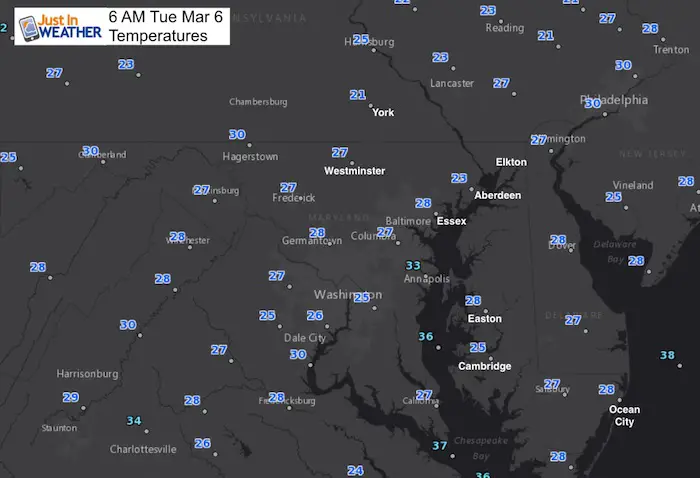
This morning is cold and allowing the ground to respond, but we still have a mild day in the 40s ahead. This is when we get to see how we can see high temperatures above freezing but a snow storm in between. The updated timeline below shows the development of rain and snow by this evening as a Nor’easter forms off of the coast. There is a second piece of energy that will feed into the storm Wednesday morning that will really allow it to take off. So there will be one pulse overnight as snow spreads across the northern half of the area. Then a second pulse during the morning as the storm intensifies.
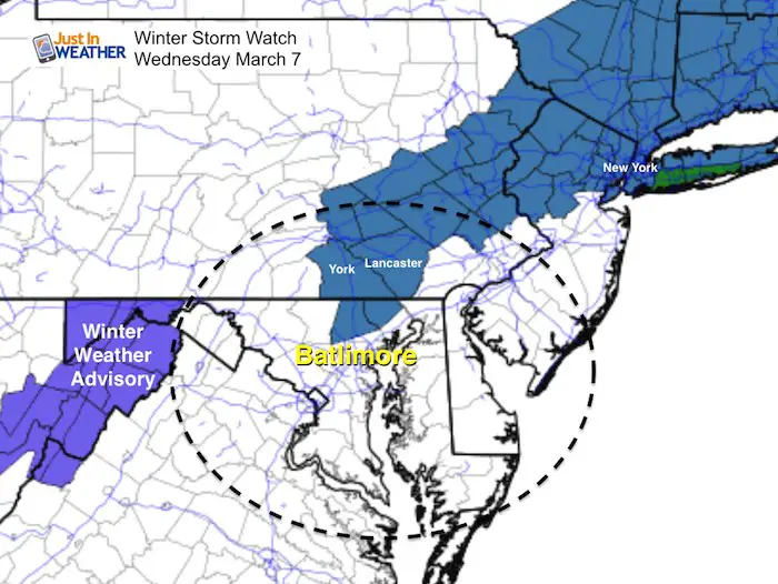
Winter Storm Watch remains in the same areas. I expect the upgrade today to warnings and advisories based on snow amounts. The heavy zones could have 1 to 2 inch per hours rates on Wednesday. Some areas not under a watch will be in an advisory, but still expect the most snow east and northeast parts of our region.
I will post my snowfall map next.
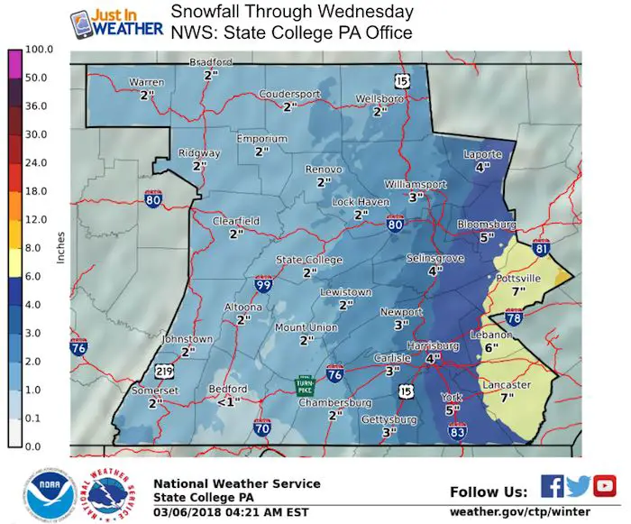
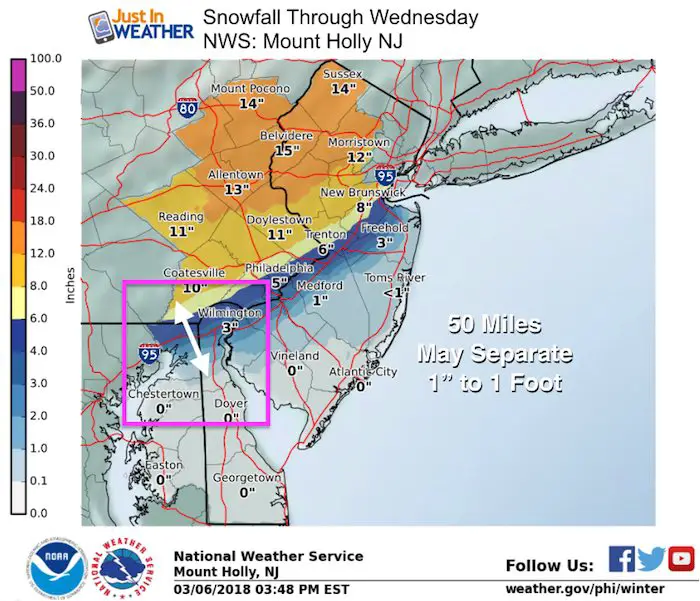
Last night I answered the most common questions along with a map breakdown of where I expect the biggest impact to be. I have linked to that below. Please keep in mind that when you hear about snow potential in a county, that does not mean the entire county. The most snow will fall in Harford and Cecil in Maryland, but the gradient will be tight, meaning a wide range from low to high amounts over a short distance. In Pennsylvania that gradient will increase from York to Lancaster with more to the east. See the latest timeline below. Also the latest look at anther storm trying to arrive at the end of the weekend.
Stats For March 6
Average High: 50ºF
Record High: 76ºF in 1935
Average Low: 31ºF
Record Low: 10ºF in 1915
Snow Record: 10.0″ in 1962
Seasonal Snow To Date (at BWI): 8.7″
Sunrise: 6:31 AM
Sunset 6:04 PM
*Daylight = 2:33 longer than yesterday
*Bay Water Temperature = 41ºF at Thomas Pt. Light House
Keep In Touch Every Day
Click here to sign up for email alerts…. Just in case you don’t get the post on your social media feed
This Morning
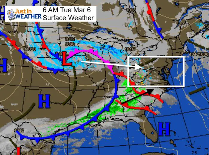
Surface Weather Map
This storm already produced blizzard conditions in the northern plains, but that is only the second piece of energy feeding into this new storm. The main energy is flowing in from the south and will provide rain and snow showers this evening. A new Low will form off of the coast.
FITF Sale
To celebrate the late season snow storm, all FITF webstore apparel is now 20%. Use promo code: marchsnow
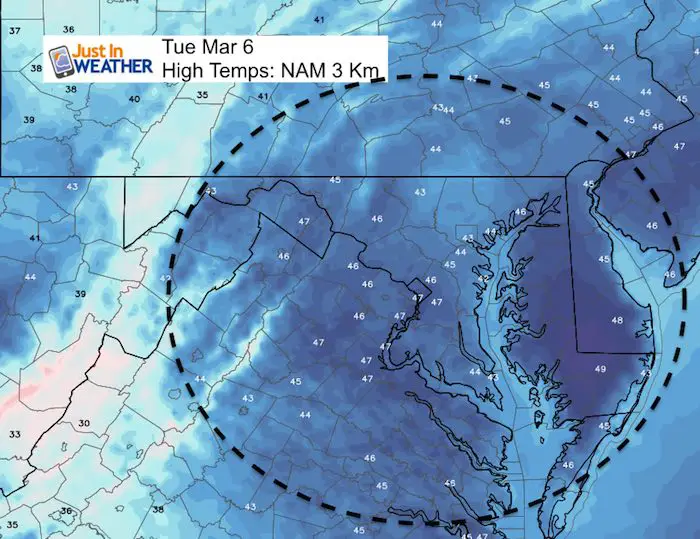
Today:
High Temperatures
Snow Timeline Radar Simulation —> slider
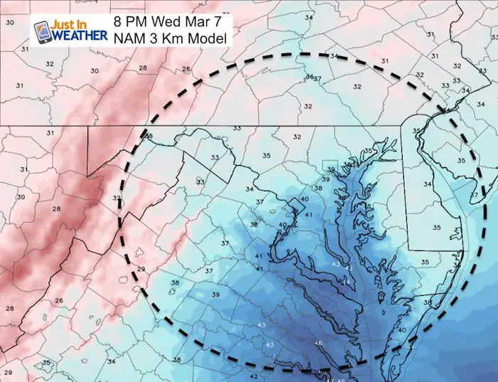
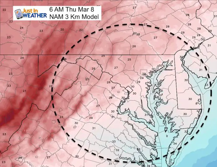
This is the NAM 3 Km Model. I chose this because it has the best record all winter. Note the snow falling but most areas stay above freezing. The darker blue represents the heavier snow and it will take more intensity to overtake the ground to lay and stay. Once it forms a layer, then more can accumulate. So some flakes will be wasted in the process.
Note the band approaching from the west Wednesday morning, then causing the storm to intensity. Snow will ease up in the morning then intensity before noon.
[metaslider id=59676]
Temperatures
This is important for stickage and melting underneath. Also a re-freeze by Thursday morning.
Wednesday Evening Temperatures
Thursday Morning = some icing
My Snow Outlook Map
Also see: Snow Impact Breakdown Q and A
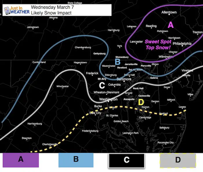
A: This is the Sweet Spot. This most snow will fall in eastern PA and may clip northern Cecil Co Maryland and northern Delaware.
B: Snow will fall overnight Tuesday and should have a cover on the ground Wednesday morning. A general 1 to 3+ inches is likely by morning, with upside potential based on how much can stick before daybreak to allow more to stick during the day.
C: Snow will mix in and change over Wednesday morning. It will snow during the day especially near Washington and east, but not stick on the roads. Roads should be wet. I-95 in Harford and Cecil county may be close to the stickage and melting line. It will be a tight gradient.
D: Snow will mix in here but little to no stickage is expected.
Snowfall Forecast Maps
Computer Models
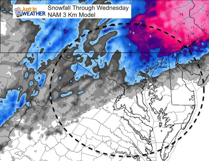
NAM 3 Km
This model has the best performance for us all winter, so I need to stick with it now. I know it is the most aggressive and I know its weakness. So, please consider this with a grain of salt. I will make my own snow outlook map on Tuesday.
This looks a bit more realistic than the prior run I showed in my last report. There is still a big question about the stickage amount, but the zone for peak snow is my focus since this model did the best with our last snow event and much of this winter.
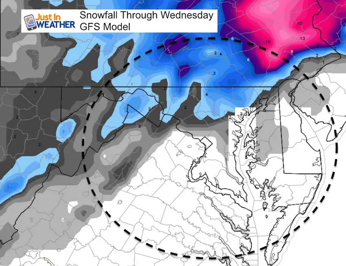
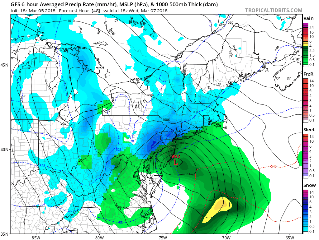
GFS
National Weather Service Regions
While this shows 2 to 3 inches in Westminster and Baltimore, look closely at the gradient and jump to Bel Air and northeast with more.
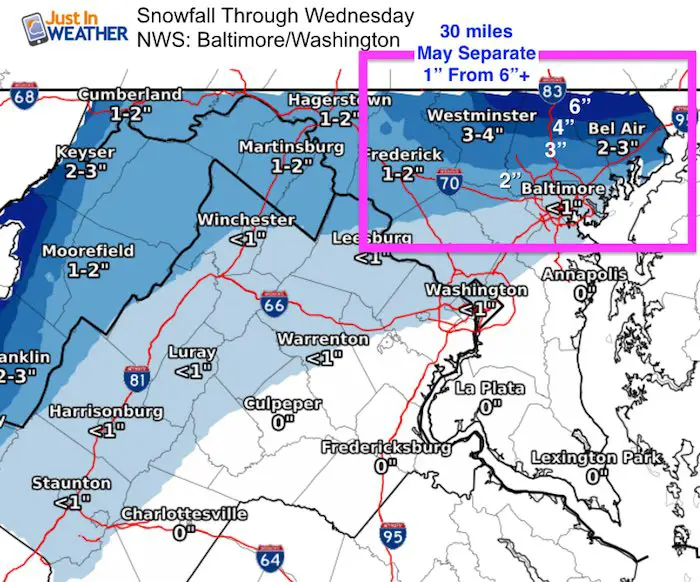
The jump from 3 inches Gettysburg to 5 inches in York and 7 inches in Lancaster could actually be more on the east end.
NWS shows Cecil County with a range from 1 inch in the south to 7 inches in the north. Just a sample of the spread in one county and it could be more pronounced depending on the banding snow.
Reminder: Winter Storm Watch means it may happen. I see some areas not highlighted here that could get in on an advisory
Outlook
Another storm will try to develop over the end of the weekend. The latest run of the GFS keeps this father south. We really need to see how this fort storm behaves to know how the second one will respond and track.
Please share your thoughts, best weather pics/video, or just keep in touch via social media
-
Facebook: Justin Berk, Meteorologist
-
Twitter: @JustinWeather
-
Instagram: justinweather
Keep In Touch Every Day
Click here to sign up for email alerts…. Just in case you don’t get the post on your social media feed
FITF Sale
To celebrate the late season snow storm, all FITF webstore apparel is now 20%. Use promo code: marchsnow now! Shop FITF

Snowstix- We Need You To Measure Snow Too
We are giving 10% of each sale to programs that benefit pediatric oncology patients.

 Get the award winning Kid Weather App I made with my oldest son and support our love for science, weather, and technology. Our 3 year anniversary of the release and our contribution to STEM education is this November. It has been downloaded in 60 countries, and works in both temperature scales. With your support we can expand on the fun introduction to science and real weather.
Keep In Touch All Winter
Click here to sign up for email alerts…. Just in case you don’t get the post on your social media feed
Also See:
My Winter Outlook 2017-2018 for more snow
La Nina Formed: What it could mean to our winter
NOAA Winter Outlook: Not The Best But Not The Worst For Snow
Two Farmers Almanacs Winter 2018 Outlooks
Winter Weather Folkore: Suggestions from Animals and Crops
First Frost and Freeze Dates For Maryland (southern PA and northern VA)
My Preliminary Winter Outlook Notes
Low Snow Winters In Baltimore: To Repeat Or Not Repeat
NOAA Ranks Blizzard 2016 4th Worst Snowstorm On Record