 March 5 2018 3:50 PM Update
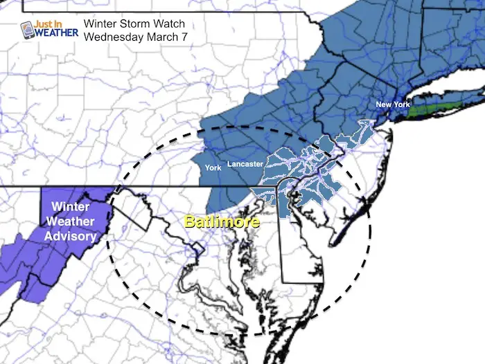
A Winter Storm Watch has been issued for southern Pennsylvania with the expectation of 6 to 10 inches of snow and over 5 inches in northern Maryland. The timing varies among NWS regions, but essentially most of Wednesday with the emphasis on the morning for travel issues. Due to the new model information that I showed in my last report, there is reason to believe that we could have a significant snowfall in our area. As is often the case, places farther inland have a better chance of snow laying and staying. So the colder areas in the higher elevations and farther away from the Chesapeake Bay in Maryland include northern Baltimore and Hartford Counties. Cecil County was just added due to being closer to the storm. If you remember the last event and the heavy snow bands they had in the afternoon, that could be the case again this time.
Stickage in March with above freezing air?
The timing might allow for more stickage and accumulation despite the temperatures struggling to get below freezing. However, York and Lancaster Counties does have a chance to get temps down to freezing at night.
We need to consider the intensity of heavy snow that can lay and accumulated faster than snow can melt. Also, snow falling overnight into early Wednesday morning will allow for a coating to keep the temps colder when the sun comes up. Even warmer pavement can get some slushy accumulation and make for a tough commute.
There will also be moderate snow and accumulation into northern Maryland as well. How far south this reaches is the tough call now. But Baltimore and the surrounding suburbs especially north of the beltway should pay close attention.
Key Snow Time Stamps –> slider
[metaslider id=59580]
We need to consider the intensity of heavy snow that can lay and accumulated faster than snow can melt. Also, snow falling overnight into early Wednesday morning will allow for a coating to keep the temps colder when the sun comes up. Even warmer pavement can get some slushy accumulation and make for a tough commute.
Even with heavy snow, it is likely the worst snow conditions will be Wednesday morning, as daylight will battle for wet pavement after 9 or 10 AM. Then wind will be the issue as the storm cranks up along the New Jersey coast Wednesday afternoon.
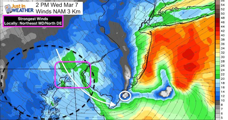
See the hourly wind timeline sliders: Click here
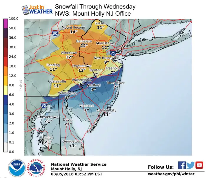
Snowfall Expectations
FITF 20% OFF Sale
To celebrate the late season snow storm, all FITF webstore apparel is now 20%. Use promo code: marchsnow now! Shop FITF
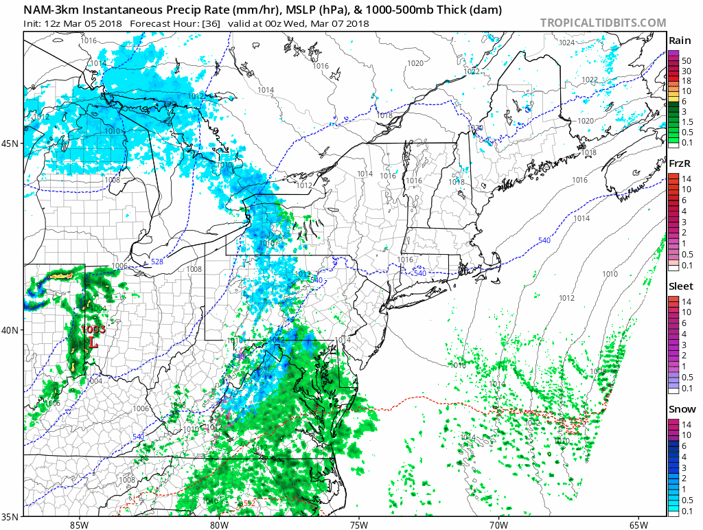
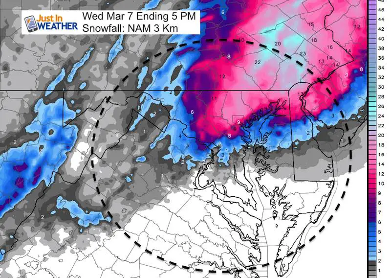
Snow Develops Rapidly Overnight Tuesday into Wednesday Morning
This NAM 3 Km animation snows the snow line on the north side of Baltimore Tuesday night and then expending south to cover all of central Maryland during the day Wednesday. The heavy snow overnight and in the morning should be enough to overtake the warmer ground and allow for slushy stickage.
National Weather Service Office Snow Products
Here are the regional NWS Forecast Outlooks guiding Watches. See the Model Snowfall Products below.
The local Sterling VA Office is showing a tight gradient of snow north of Baltimore. But as I showed in my prior report, the NAM 3 KM model plus the colder air farther south and shifts the heavy snow into metro areas. This is the bust zone this time and it could be an overachiever. Stay tuned.

Notice the High Totals for York and Lancaster (State College Office) but the western suburbs of Philadelphia (Mount Holly NJ Office) does not match up. I think the evening crew will adjust this.
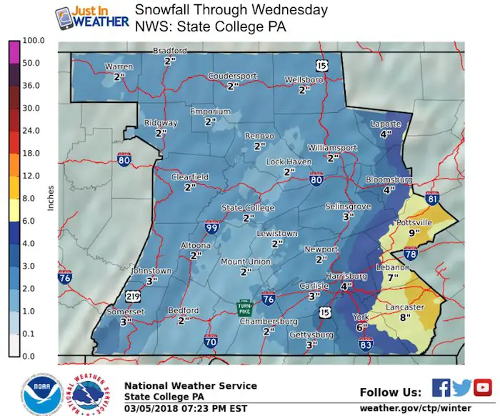
It is possible that the amounts seen from this office will increase and that will adjust the Watch counties for Cecil, Kent in MD and northern Delaware.
Snow Totals
NAM 3Km Model
This model exploding with snowfall across our region. Normally I would scoff at this and cal it insane! But it was on point with the snow locations in our last event. I still have trouble seeing 9 inches laying and staying in. Baltimore. However, I think much of this will be lost to melting and compaction. Compare to two more models below and stand by for more:
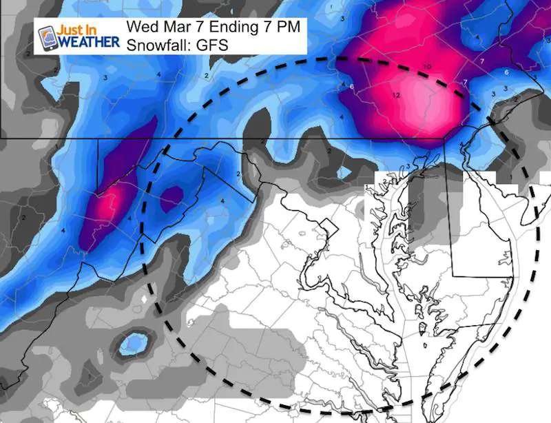
GFS Model
The main American Model here shows the bullseye from eastern York through Lancaster Counties in PA. The northern Maryland zones are in the 3″+ but Baltimore struggles to get 1 inch.
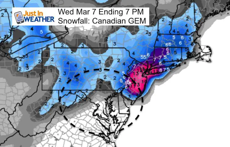
Canadian GEM Model
Please check back this evening for more storm updates and snow outlook maps.
Please share your thoughts, best weather pics/video, or just keep in touch via social media
-
Facebook: Justin Berk, Meteorologist
-
Twitter: @JustinWeather
-
Instagram: justinweather
Keep In Touch Every Day
Click here to sign up for email alerts…. Just in case you don’t get the post on your social media feed
FITF Sale
To celebrate the late season snow storm, all FITF webstore apparel is now 20%. Use promo code: marchsnow now! Shop FITF

Snowstix- We Need You To Measure Snow Too
We are giving 10% of each sale to programs that benefit pediatric oncology patients.

 Get the award winning Kid Weather App I made with my oldest son and support our love for science, weather, and technology. Our 3 year anniversary of the release and our contribution to STEM education is this November. It has been downloaded in 60 countries, and works in both temperature scales. With your support we can expand on the fun introduction to science and real weather.
Keep In Touch All Winter
Click here to sign up for email alerts…. Just in case you don’t get the post on your social media feed
Also See:
My Winter Outlook 2017-2018 for more snow
La Nina Formed: What it could mean to our winter
NOAA Winter Outlook: Not The Best But Not The Worst For Snow
Two Farmers Almanacs Winter 2018 Outlooks
Winter Weather Folkore: Suggestions from Animals and Crops
First Frost and Freeze Dates For Maryland (southern PA and northern VA)
My Preliminary Winter Outlook Notes
Low Snow Winters In Baltimore: To Repeat Or Not Repeat
NOAA Ranks Blizzard 2016 4th Worst Snowstorm On Record