February 28 2018
After only the second sunny day of the month, we close out February with increasing clouds and mild temperatures. This month is on pace to finish as the 15th warmest February on record in Baltimore, and we will pay for it. March is going to roar in like a lion with a strong storm set to blow up off of the coast. It will usher in colder air, but as the storm departs. So it will begin with rain Thursday and end Friday with strong winds and perhaps some flurries. The issue will be the winds that can produce some damage.
The outlook below highlights the rain timeline and peak winds, but the second half of the weekend will improve. Then we stay in a cooler and busy pattern for the first half of February.
Stats For February 28
Average High: 48ºF
Record High: 71ºF in 1903
Average Low: 29ºF
*Former Record Low: 5ºF in 1934
Snow Record: 5.2″ in 1949
Seasonal Snow To Date (at BWI): 8.7″
Sunrise: 6:40 AM
Sunset 5:57 PM
*Daylight = 2:31 longer than yesterday
*Bay Water Temperature = 42ºF at Thomas Pt. Light House
Keep In Touch Every Day
Click here to sign up for email alerts…. Just in case you don’t get the post on your social media feed
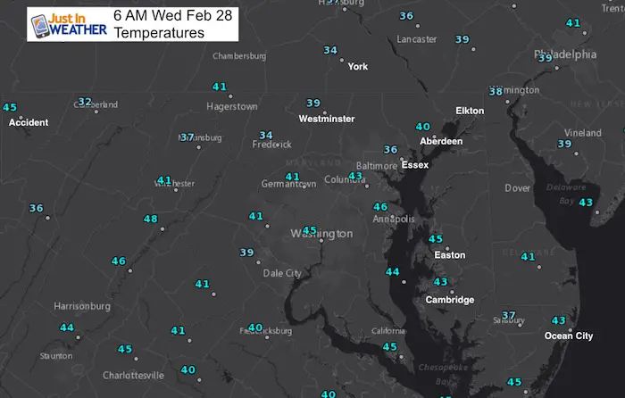
This Morning
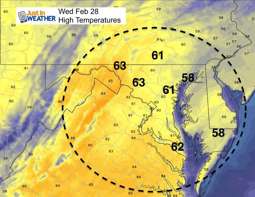
This Afternoon: High Temperatures
HRRR Model
Rain Storm Animation
Thursday Afternoon Through Saturday Afternoon
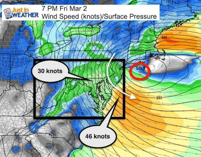
Wind Storm
The storm off of the coast will reach its peak on Friday evening. This map below Showa the location of the Low Pressure south of Long Island NY and dropping southeast. The pressure gradient will be increasing the wind all day. Inland areas can expect wind speeds between 30 and 40 mph, with gusts event higher. The best chance for sustained winds over 40 mph will be along the coat Friday evening and overnight.
Winds will remain strong on Saturday, but ease a little as the colder air settles in.
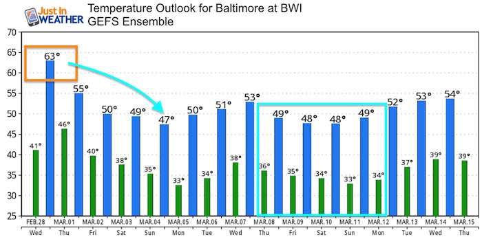
Temperature Outlook
I think think the modeling is having a hard time identifying how cold we will get with the pattern change. So the default is close to average.
Please share your thoughts, best weather pics/video, or just keep in touch via social media
-
Facebook: Justin Berk, Meteorologist
-
Twitter: @JustinWeather
-
Instagram: justinweather
Keep In Touch Every Day
Click here to sign up for email alerts…. Just in case you don’t get the post on your social media feed
FITF Gear

Snowstix- We Need You To Measure Snow Too
We are giving 10% of each sale to programs that benefit pediatric oncology patients.

 Get the award winning Kid Weather App I made with my oldest son and support our love for science, weather, and technology. Our 3 year anniversary of the release and our contribution to STEM education is this November. It has been downloaded in 60 countries, and works in both temperature scales. With your support we can expand on the fun introduction to science and real weather.
Keep In Touch All Winter
Click here to sign up for email alerts…. Just in case you don’t get the post on your social media feed
Also See:
My Winter Outlook 2017-2018 for more snow
La Nina Formed: What it could mean to our winter
NOAA Winter Outlook: Not The Best But Not The Worst For Snow
Two Farmers Almanacs Winter 2018 Outlooks
Winter Weather Folkore: Suggestions from Animals and Crops
First Frost and Freeze Dates For Maryland (southern PA and northern VA)
My Preliminary Winter Outlook Notes
Low Snow Winters In Baltimore: To Repeat Or Not Repeat
NOAA Ranks Blizzard 2016 4th Worst Snowstorm On Record
Blizzard 2016 Record Top Snowstorm: Area Totals
Extreme Weather of 2015 balanced out on both ends