February 26 2018
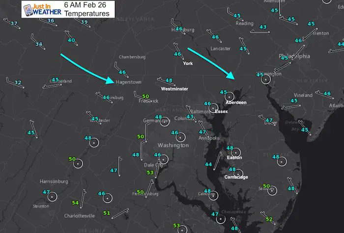
The fog from overnight is dispersing quickly thanks to a shift in the wind mixing up the air. While the warmer air didn’t make it this far north and was yesterday, we should see some sun as we dry out and warm up today. The next few days will be quiet and allow us to warm up a little. But the next storm starts to show itself late Wednesday and Thursday. Plan for a very wet end to the week, and then a very rare upper air pattern that will try to send in colder air and stronger storms for the middle of March.
Stats For February 26
Average High: 48ºF
Record High: 74ºF in 1932
Average Low: 29ºF
*Former Record Low: 13ºF in 1990
Snow Record: 3.0″ in 1993
Seasonal Snow To Date (at BWI): 8.7″
Sunrise: 6:43 AM
Sunset 5:55 PM
*Daylight = 2:30 longer than yesterday
*Bay Water Temperature = 42ºF at Thomas Pt. Light House
Keep In Touch Every Day
Click here to sign up for email alerts…. Just in case you don’t get the post on your social media feed
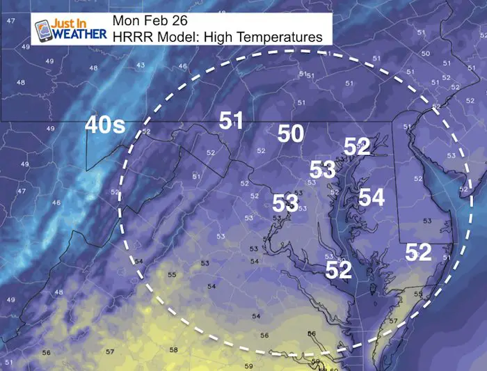
How Warm This Afternoon?
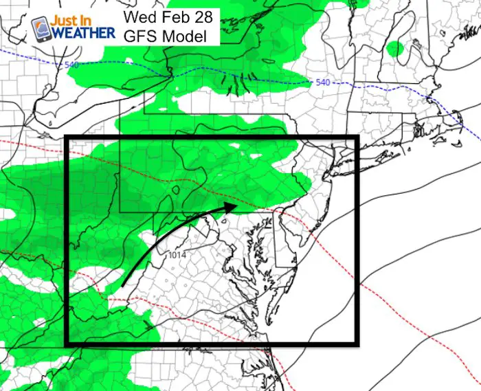
Next Chance Of Rain
Wednesday Evening
The threat of showers will be along the front ridge and hills inland from the city and Bay.
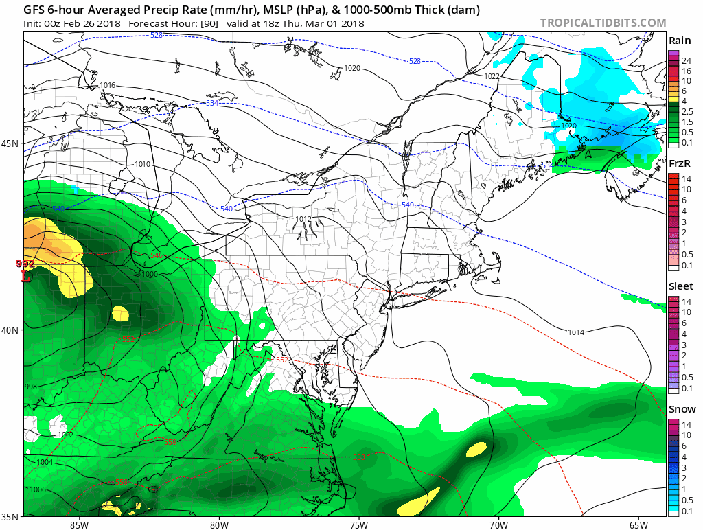
Friday Storm
The pattern change will come with the storm at the end of the week. Showers will arrive Thursday with heavy rain on Friday morning. This will be followed by the flip in the jet stream.
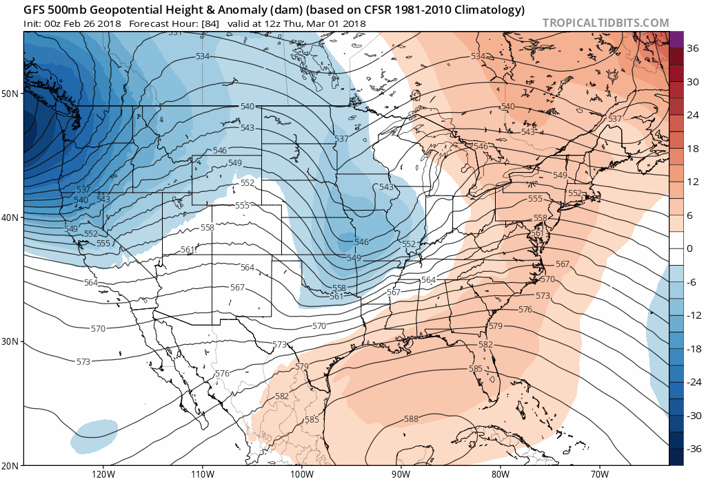
Jet Stream
After warm temperatures mid week, we will see the pattern flip with the end of week storm. Then a pronounced trend to cooler air aloft into mid March as seen in blue. March 7 to 14 shows the building of possible record low heights in the trough over the east coast. The temperature outlook below does not accurately reflect this due to limitation in the modeling.
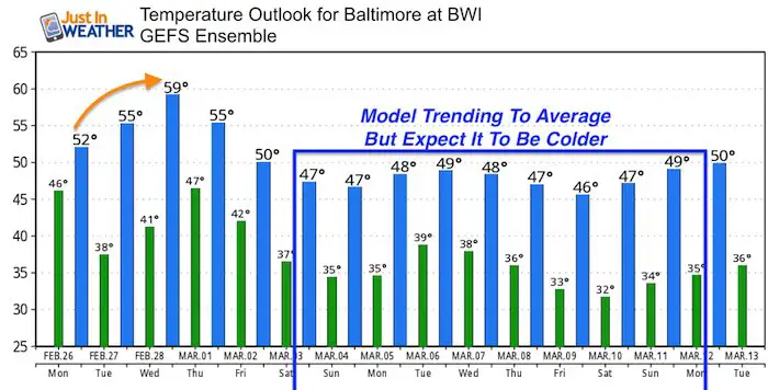
Temperature Outlook
I think think the modeling is having a hard time identifying how cold we will get with the pattern change. So the default is close to average.
Please share your thoughts, best weather pics/video, or just keep in touch via social media
-
Facebook: Justin Berk, Meteorologist
-
Twitter: @JustinWeather
-
Instagram: justinweather
Keep In Touch Every Day
Click here to sign up for email alerts…. Just in case you don’t get the post on your social media feed
FITF Gear

Snowstix- We Need You To Measure Snow Too
We are giving 10% of each sale to programs that benefit pediatric oncology patients.

 Get the award winning Kid Weather App I made with my oldest son and support our love for science, weather, and technology. Our 3 year anniversary of the release and our contribution to STEM education is this November. It has been downloaded in 60 countries, and works in both temperature scales. With your support we can expand on the fun introduction to science and real weather.
Keep In Touch All Winter
Click here to sign up for email alerts…. Just in case you don’t get the post on your social media feed
Also See:
My Winter Outlook 2017-2018 for more snow
La Nina Formed: What it could mean to our winter
NOAA Winter Outlook: Not The Best But Not The Worst For Snow
Two Farmers Almanacs Winter 2018 Outlooks
Winter Weather Folkore: Suggestions from Animals and Crops
First Frost and Freeze Dates For Maryland (southern PA and northern VA)
My Preliminary Winter Outlook Notes
Low Snow Winters In Baltimore: To Repeat Or Not Repeat
NOAA Ranks Blizzard 2016 4th Worst Snowstorm On Record