Friday February 23 2018
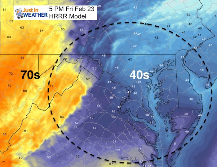
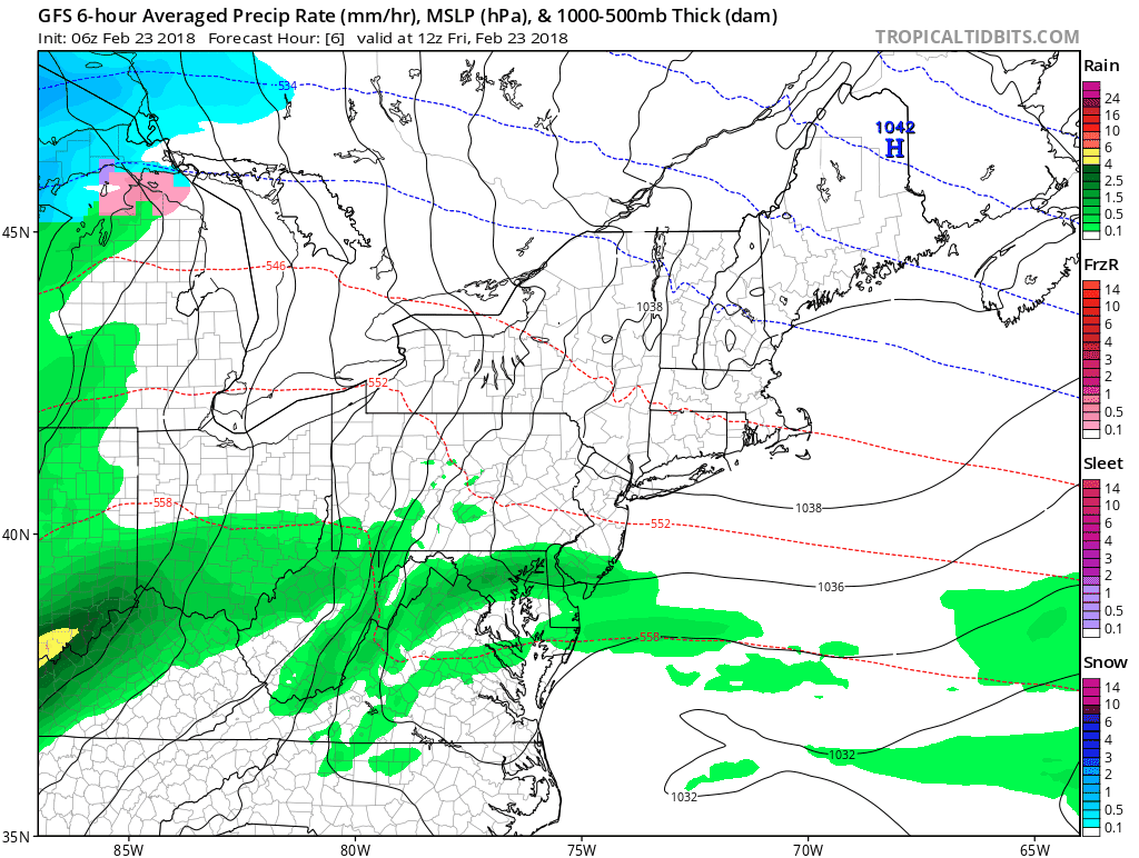
A band of rain already moved through this morning, but the good news is that the heaviest rain is moving out… for now. We are in a cool and damp pattern that will send more rain our way through the weekend. There is another push of warmer air, but it will be slow to return. This afternoons temperatures are likely to stay in the the 40s while western Virginia and perhaps western Maryland could get back to the 70s.
Stats For February 23
Average High: 47ºF
Record High: 78ºF in 1874
Average Low: 28ºF
*Former Record Low: +5ºF in 1963
Snow Record: 6.1″ in 1987
Seasonal Snow To Date (at BWI): 8.7″
Sunrise: 6:47 AM
Sunset 5:52 PM
*Daylight = 2:29 longer than yesterday
*Bay Water Temperature = 42ºF at Thomas Pt. Light House
Keep In Touch Every Day
Click here to sign up for email alerts…. Just in case you don’t get the post on your social media feed
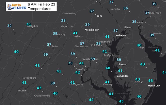
This Morning
Afternoon Temperatures
HRRR
Rain Timeline Today
—> slider
[metaslider id=58524]
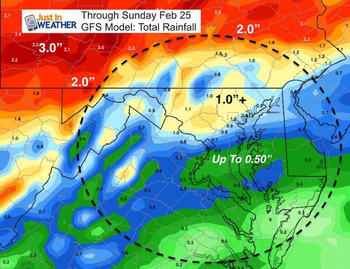
Rainy Pattern
The bulk of rain will fall on the norther part of our region. We should get a break Saturday, until afternoon. But Sunday looks to be more wet for all of us
Rainfall Total
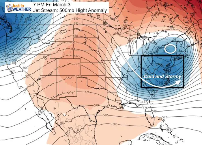
Pattern Change
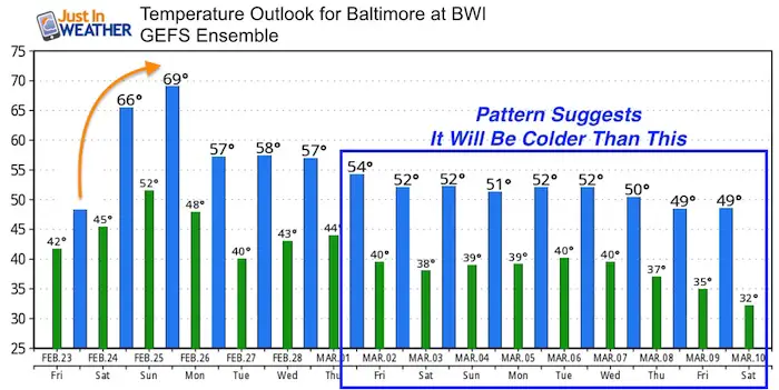
Warming back up early next week… But not as warm as we just had. More likely closer to 70ºF
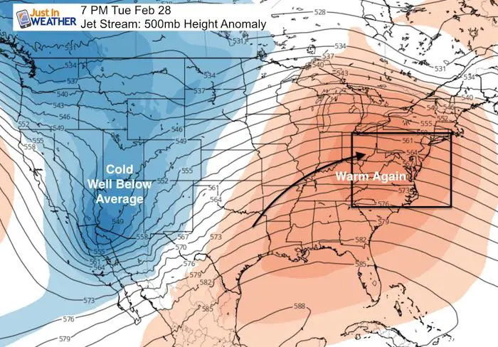
The pattern flip will be noticeable by the end of next week
Temperature Outlook
Please share your thoughts, best weather pics/video, or just keep in touch via social media
-
Facebook: Justin Berk, Meteorologist
-
Twitter: @JustinWeather
-
Instagram: justinweather
Keep In Touch Every Day
Click here to sign up for email alerts…. Just in case you don’t get the post on your social media feed
FITF Gear

Snowstix- We Need You To Measure Snow Too
We are giving 10% of each sale to programs that benefit pediatric oncology patients.

 Get the award winning Kid Weather App I made with my oldest son and support our love for science, weather, and technology. Our 3 year anniversary of the release and our contribution to STEM education is this November. It has been downloaded in 60 countries, and works in both temperature scales. With your support we can expand on the fun introduction to science and real weather.
Keep In Touch All Winter
Click here to sign up for email alerts…. Just in case you don’t get the post on your social media feed
Also See:
My Winter Outlook 2017-2018 for more snow
La Nina Formed: What it could mean to our winter
NOAA Winter Outlook: Not The Best But Not The Worst For Snow
Two Farmers Almanacs Winter 2018 Outlooks
Winter Weather Folkore: Suggestions from Animals and Crops
First Frost and Freeze Dates For Maryland (southern PA and northern VA)
My Preliminary Winter Outlook Notes
Low Snow Winters In Baltimore: To Repeat Or Not Repeat
NOAA Ranks Blizzard 2016 4th Worst Snowstorm On Record
Blizzard 2016 Record Top Snowstorm: Area Totals
Extreme Weather of 2015 balanced out on both ends