 Sunday February 25 2018
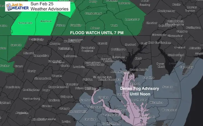
Do you remember that severe drought we were in? I think its safe to say it is pretty much over. We have had plenty of rain and now a Flood Watch across Pennsylvania. One more batch of rain trying to usher in some warmer air later today is also producing some thick fog between Anne Arundel County, Southern Maryland, and the Eastern Shore. The Dense Fog Advisory has been extended until noon, but should ease up in these areas as the rain moves back in over the morning hours. Meanwhile the rain will be ending on the north side sooner and perhaps some sun peaking out this afternoon.
Overall, the pattern shows us more rain and a flip to a much colder set up at the end of this week and the first half of March. I DO NOT believe in showing long range plot for storms as the models have proven they are not trustworthy. So if you have seen a snowstorm from some other weather source, it already has changed. But, I believe we are set up to get snow in the first 10 days of March. So winter is not done yet!
Stats For February 25
Average High: 47ºF
Record High: 83ºF in 1930
Average Low: 28ºF
*Former Record Low: +58ºF in 1914
Snow Record: 5.0″ in 1934
Seasonal Snow To Date (at BWI): 8.7″
Sunrise: 6:44 AM
Sunset 5:54 PM
*Daylight = 2:30 longer than yesterday
*Bay Water Temperature = 42ºF at Thomas Pt. Light House
Keep In Touch Every Day
Click here to sign up for email alerts…. Just in case you don’t get the post on your social media feed
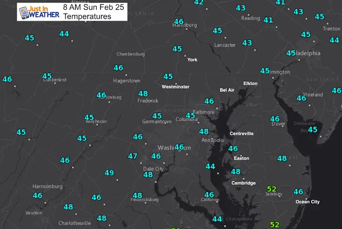
Morning Temperatures
Rain Timeline Today
Notice the potential for a line of heavy showers or even a Thunderstorm pop up near Kent Island and southward after 5 PM
—> slider
[metaslider id=58582]
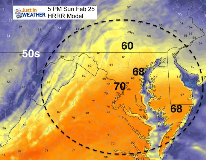
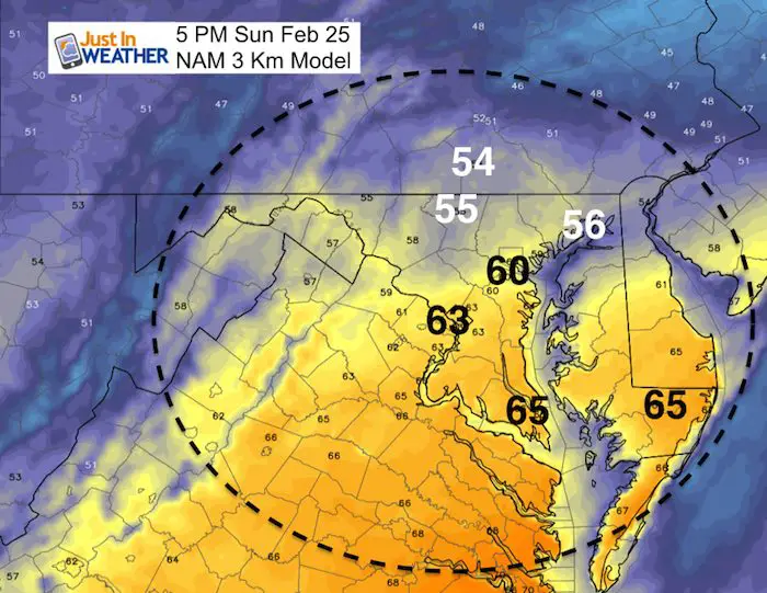
How Warm This Afternoon?
The HRRR Model is pushing in much warmer air than GFS. It will be warm but the difference depends on how much sun we can get and when. Either upper 50s to near 60ºF or upper 60s in central Maryland
Pattern Change
The next rain event will arrive on Thursday. This is the leading edge of the big change
Jet Stream Flip
Watch the change from our warm (orange) to colder (blue) Temperature Anomalies aloft.
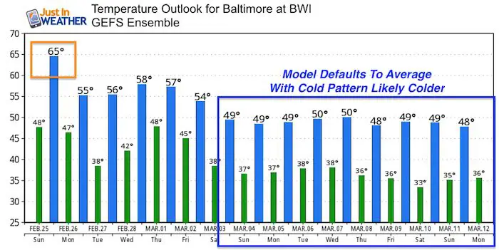
Temperature Outlook
I think think the modeling is having a hard time identifying how cold we will get with the pattern change. So the default is close to average.
Please share your thoughts, best weather pics/video, or just keep in touch via social media
-
Facebook: Justin Berk, Meteorologist
-
Twitter: @JustinWeather
-
Instagram: justinweather
Keep In Touch Every Day
Click here to sign up for email alerts…. Just in case you don’t get the post on your social media feed
FITF Gear

Snowstix- We Need You To Measure Snow Too
We are giving 10% of each sale to programs that benefit pediatric oncology patients.

 Get the award winning Kid Weather App I made with my oldest son and support our love for science, weather, and technology. Our 3 year anniversary of the release and our contribution to STEM education is this November. It has been downloaded in 60 countries, and works in both temperature scales. With your support we can expand on the fun introduction to science and real weather.
Keep In Touch All Winter
Click here to sign up for email alerts…. Just in case you don’t get the post on your social media feed
Also See:
My Winter Outlook 2017-2018 for more snow
La Nina Formed: What it could mean to our winter
NOAA Winter Outlook: Not The Best But Not The Worst For Snow
Two Farmers Almanacs Winter 2018 Outlooks
Winter Weather Folkore: Suggestions from Animals and Crops
First Frost and Freeze Dates For Maryland (southern PA and northern VA)
My Preliminary Winter Outlook Notes
Low Snow Winters In Baltimore: To Repeat Or Not Repeat
NOAA Ranks Blizzard 2016 4th Worst Snowstorm On Record