 February 21 2018
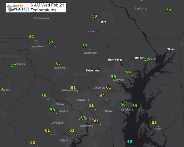
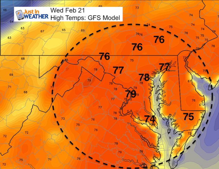
It feels like spring for sure and these morning temperatures in the 50s and 60s prove it. It might be hard to image but just three days after we had snow, the temperatures jumped into the upper 70s on Tuesday. Baltimore’s BWI tied the record for February 20 with 76ºF and it appears we will break the record today. The interesting thing about these dates is that there was a mini heat wave in 1930, but also a mini arctic surge just a few years ago. Both February 20 and 21 have the record low temps in Baltimore in 2015 (+1ºF, +º2F).
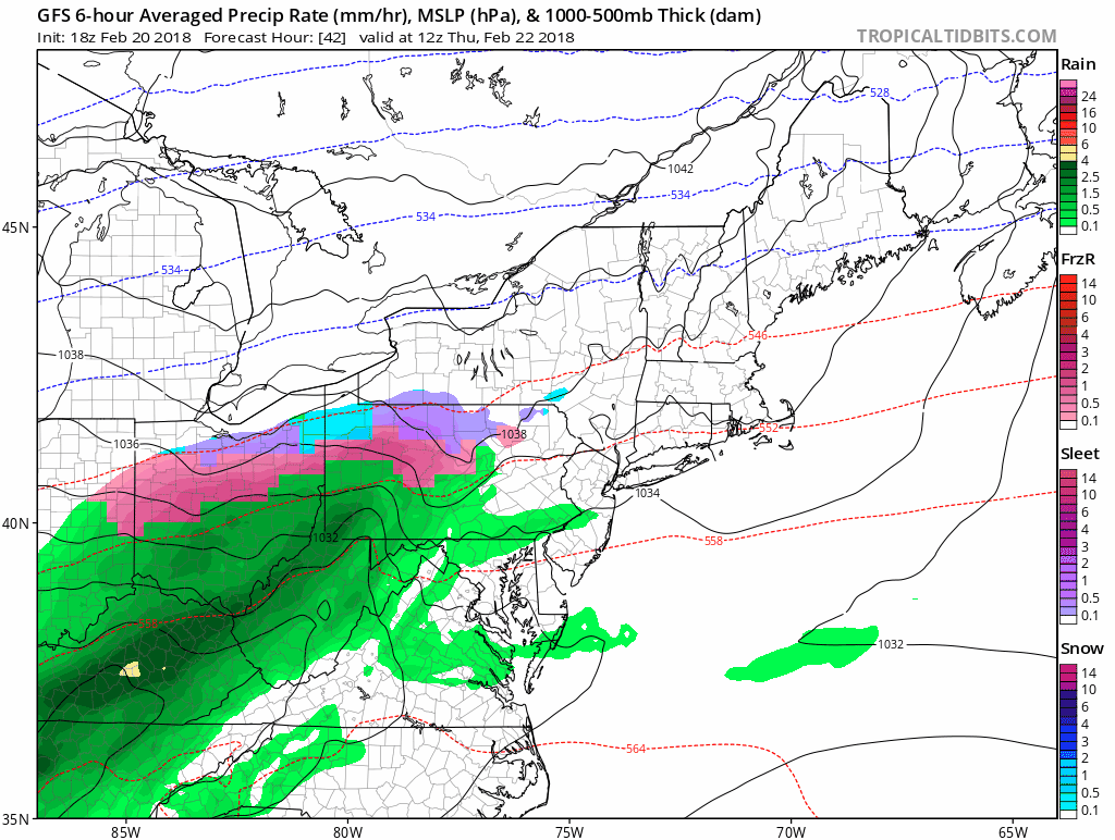
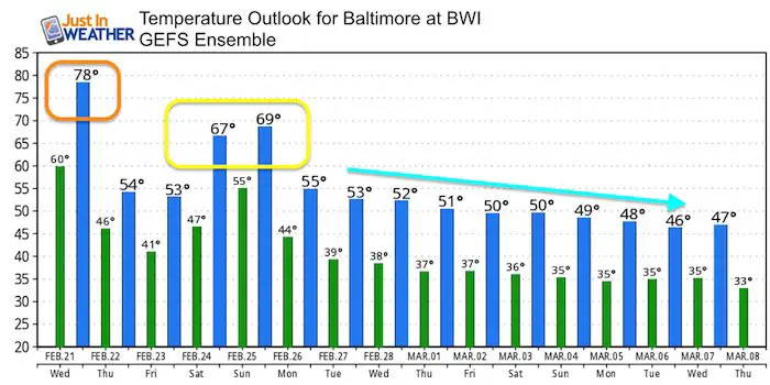
Today will start with some fog and then some sun will help the jump into the upper 70s. This day will be different as it will feature some showers and possibly a thunderstorm in the evening. There is weather folklore that states, “if in winter there is thunder, snow will fall in a week or under”. It may not be a week, but the pattern is supporting a very cold start to March with an active storm pattern. It looks like snow is not done with us yet.
Stats For February 20
Note: A few people have asked me about the term normal vs using average. Scientifically ‘average’ is a better term for the stats below, but The National Weather Service has used the ‘normal’ term in their climate data. I have switched it below to satisfy the fellow science geeks.
Average High: 46ºF
Record High: 74ºF in 1930
Average Low: 27ºF
*Former Record Low: +2ºF in 2015
Snow Record: 10.3″ in 1929
Seasonal Snow To Date (at BWI): 8.7″
Sunrise: 6:50 AM
Sunset 5:50 PM
*Daylight = 2:27 longer than yesterday
*Bay Water Temperature = 39ºF at Thomas Pt. Light House
Keep In Touch Every Day
Click here to sign up for email alerts…. Just in case you don’t get the post on your social media feed
Today
Evening Thunderstorms
—> slider
[metaslider id=58250]
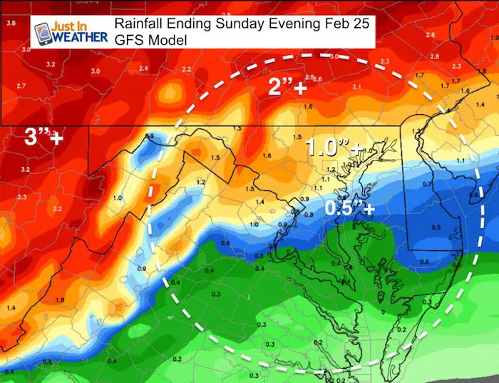
Rainy Pattern Thursday Through Sunday
Rainfall Potential
Temperature Outlook
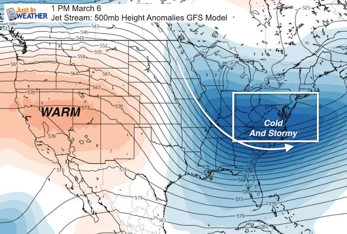
Jet Stream: Early March
Please share your thoughts, best weather pics/video, or just keep in touch via social media
-
Facebook: Justin Berk, Meteorologist
-
Twitter: @JustinWeather
-
Instagram: justinweather
Keep In Touch Every Day
Click here to sign up for email alerts…. Just in case you don’t get the post on your social media feed
FITF Gear

Snowstix- We Need You To Measure Snow Too
We are giving 10% of each sale to programs that benefit pediatric oncology patients.

 Get the award winning Kid Weather App I made with my oldest son and support our love for science, weather, and technology. Our 3 year anniversary of the release and our contribution to STEM education is this November. It has been downloaded in 60 countries, and works in both temperature scales. With your support we can expand on the fun introduction to science and real weather.
Keep In Touch All Winter
Click here to sign up for email alerts…. Just in case you don’t get the post on your social media feed
Also See:
My Winter Outlook 2017-2018 for more snow
La Nina Formed: What it could mean to our winter
NOAA Winter Outlook: Not The Best But Not The Worst For Snow
Two Farmers Almanacs Winter 2018 Outlooks
Winter Weather Folkore: Suggestions from Animals and Crops
First Frost and Freeze Dates For Maryland (southern PA and northern VA)
My Preliminary Winter Outlook Notes
Low Snow Winters In Baltimore: To Repeat Or Not Repeat
NOAA Ranks Blizzard 2016 4th Worst Snowstorm On Record
Blizzard 2016 Record Top Snowstorm: Area Totals
Extreme Weather of 2015 balanced out on both ends