Tuesday February 20 2018
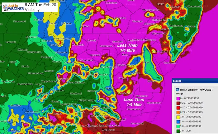
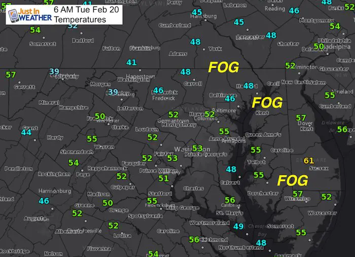
The warmer air trying to move it over the colder Chesapeake Bay and ground has produced some very thick fog this morning. Some counties on the Eastern Shore have school delays, but the fog issues are widespread around Delmarva and on the north/east side of Baltimore. These locations where visibility is under 1/4 mile is where the travel will really slow down. This will improve by 9 or 10 AM and allow the sun to return and boost our warm air.
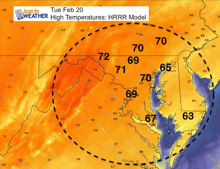
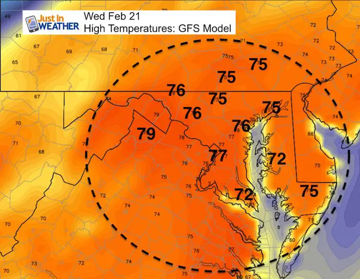
The surge of warm air on the way is going to push much of our region into the 70s over the next two days. This will challenge the so called heat wave of 1930. Records for Baltimore to watch are more likely to be in jeopardy tomorrow:
- February 20, 1930 = 76ºF
- February 21, 1930 = 74ºF
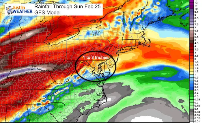
The end of our warm stretch will come with rain between Thursday and the end of the weekend. Up to 3 inches may fall in parts of our area. Then a return closer to average and even colder start to March. Winter is not done yet and I expect more chances for snow. It will just have to wait another week to 10 days.
Stats For February 19
Note: A few people have asked me about the term normal vs using average. Scientifically ‘average’ is a better term for the stats below, but The National Weather Service has used the ‘normal’ term in their climate data. I have switched it below to satisfy the fellow science geeks.
Average High: 46ºF
Record High: 76ºF in 1930
Average Low: 27ºF
*Former Record Low: +1ºF in 2015
Snow Record: 9.9″ in 1947
Seasonal Snow To Date (at BWI): 8.7″
Sunrise: 6:51 AM
Sunset 5:49 PM
*Daylight = 2:26 longer than yesterday
*Bay Water Temperature = 38ºF at Thomas Pt. Light House
Keep In Touch Every Day
Click here to sign up for email alerts…. Just in case you don’t get the post on your social media feed
This Morning
This Afternoon
Tomorrow Afternoon
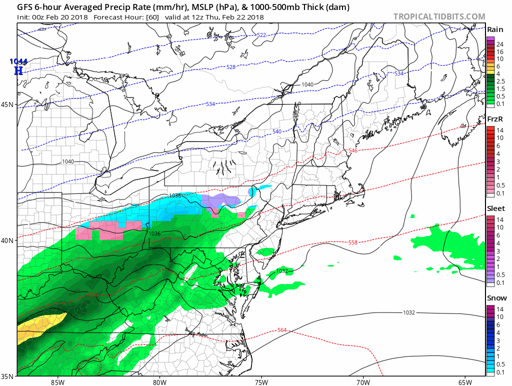
Rainy End To The Week
Some showers may reach the northmen areas Wednesday evening. But the focus will be a day later. A series of Low Pressure centers will ride along a stalled front and keep us with a chance of rain between Thursday and Sunday.
Rainfall Totals
Outlook\ Temperatures
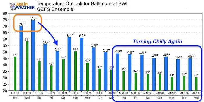
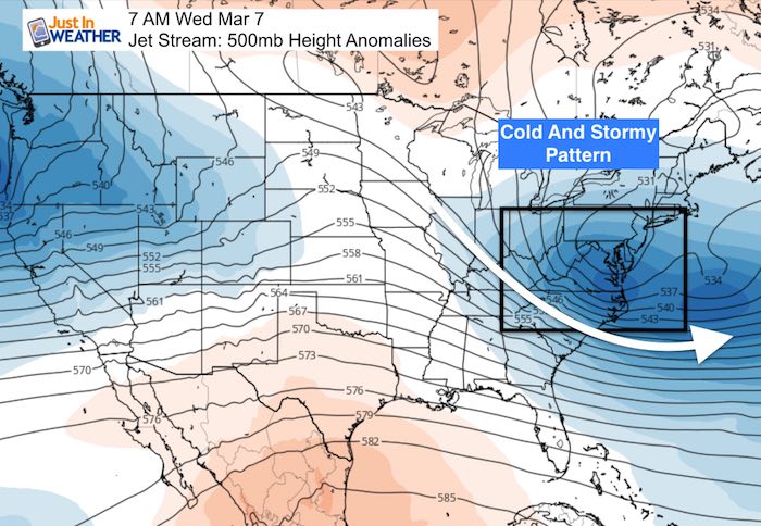
March Pattern:
The North Atlantic Oscillation has been forecast to drop into a record negative territory. Here is why. A Large blocking pattern is setting up across eastern Canada and Greenland. This will enhance the cold air and storm track for us in early March.
Often an early season warm up is met with strong return to cold
Please share your thoughts, best weather pics/video, or just keep in touch via social media
-
Facebook: Justin Berk, Meteorologist
-
Twitter: @JustinWeather
-
Instagram: justinweather
Keep In Touch Every Day
Click here to sign up for email alerts…. Just in case you don’t get the post on your social media feed
Snowstix- We Need You To Measure Snow Too
We are giving 10% of each sale to programs that benefit pediatric oncology patients.

FITF Gear
SALE on ALL FITF items All DAY SATURDAY! Use Promo Code: snow 17 for 17% to honor the date of our snow ?

 Get the award winning Kid Weather App I made with my oldest son and support our love for science, weather, and technology. Our 3 year anniversary of the release and our contribution to STEM education is this November. It has been downloaded in 60 countries, and works in both temperature scales. With your support we can expand on the fun introduction to science and real weather.
Keep In Touch All Winter
Click here to sign up for email alerts…. Just in case you don’t get the post on your social media feed
Also See:
My Winter Outlook 2017-2018 for more snow
La Nina Formed: What it could mean to our winter
NOAA Winter Outlook: Not The Best But Not The Worst For Snow
Two Farmers Almanacs Winter 2018 Outlooks
Winter Weather Folkore: Suggestions from Animals and Crops
First Frost and Freeze Dates For Maryland (southern PA and northern VA)
My Preliminary Winter Outlook Notes
Low Snow Winters In Baltimore: To Repeat Or Not Repeat
NOAA Ranks Blizzard 2016 4th Worst Snowstorm On Record
Blizzard 2016 Record Top Snowstorm: Area Totals
Extreme Weather of 2015 balanced out on both ends