Monday February 19 2018
After the weekend snow, we will jump back with warm air this week that brings at least two days into the 70s. A record heat wave in 1930 has the bench mark we will challenge, but that does not mean winter is over. In fact, I have mentioned that this early season warm up will mean a sharp crash in March. Now there is model support for just that. See more below.
Stats For February 19
Note: A few people have asked me about the term normal vs using average. Scientifically ‘average’ is a better term for the stats below, but The National Weather Service has used the ‘normal’ term in their climate data. I have switched it below to satisfy the fellow science geeks.
Average High: 46ºF
Record High: 72ºF in 1997
Average Low: 27ºF
*Former Record Low: +5ºF in 1903
Snow Record: 16.4″ in 1979
Seasonal Snow To Date (at BWI): 8.7″
Sunrise: 6:53 AM
Sunset 5:47 PM
*Daylight = 2:26 longer than yesterday
*Bay Water Temperature = 38ºF at Thomas Pt. Light House
Keep In Touch All Winter
Click here to sign up for email alerts…. Just in case you don’t get the post on your social media feed
Showers Today
Not a wash out. A band this morning and again this evening.
—> slider
[metaslider id=58210]
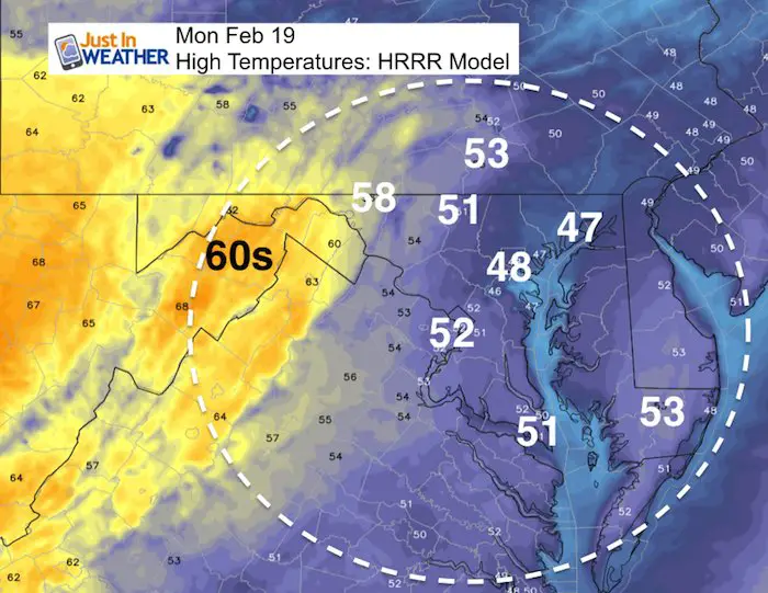
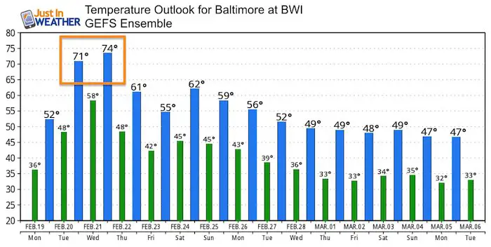
Let’s Focus on the Temperatures
Today
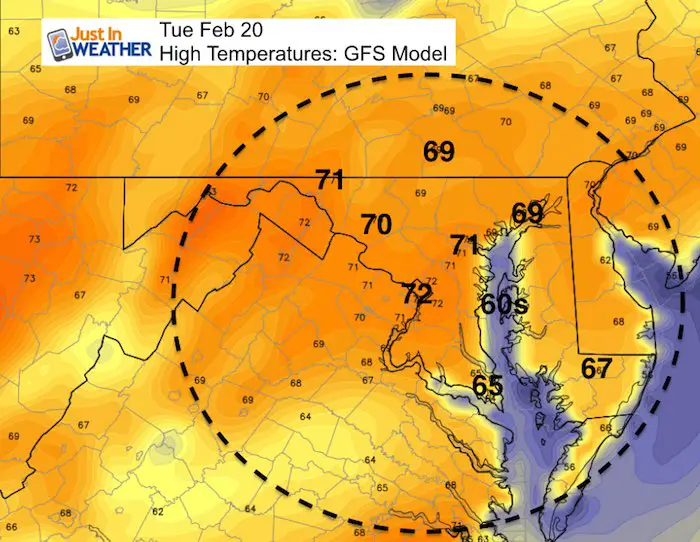
Tuesday
Record: 76ºF in 1930
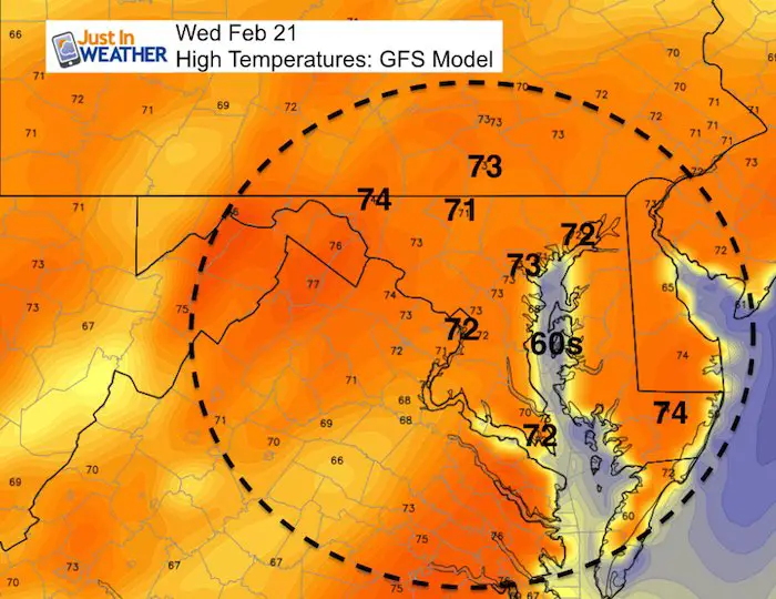
Wednesday
Record: 74ºF in 1930
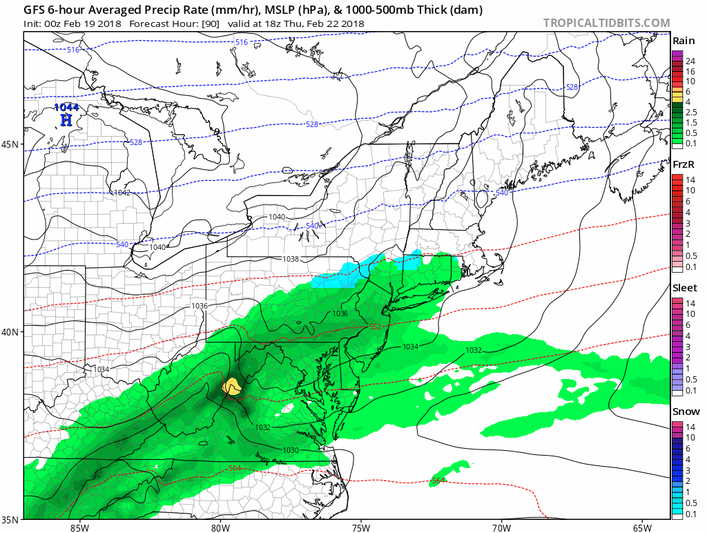
Rainy End To the Week
Thursday Through Sunday
Outlook\ Temperatures
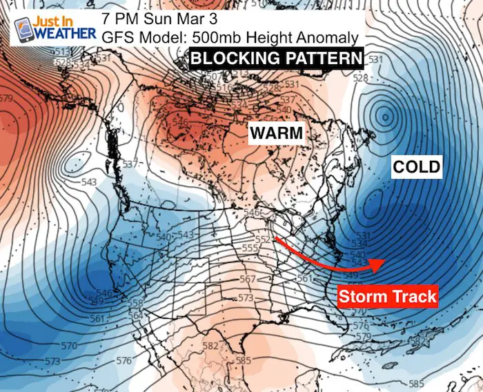
March Pattern:
The North Atlantic Oscillation has been forecast to drop into a record negative territory. Here is why. A Large blocking pattern is setting up across eastern Canada and Greenland. This will enhance the cold air and storm track for us in early March.
Often an early season warm up is met with strong return to cold
Please share your thoughts, best weather pics/video, or just keep in touch via social media
-
Facebook: Justin Berk, Meteorologist
-
Twitter: @JustinWeather
-
Instagram: justinweather
Keep In Touch All Winter
Click here to sign up for email alerts…. Just in case you don’t get the post on your social media feed
Snowstix- We Need You To Measure Snow Too
We are giving 10% of each sale to programs that benefit pediatric oncology patients.

FITF Gear
SALE on ALL FITF items All DAY SATURDAY! Use Promo Code: snow 17 for 17% to honor the date of our snow ?

 Get the award winning Kid Weather App I made with my oldest son and support our love for science, weather, and technology. Our 3 year anniversary of the release and our contribution to STEM education is this November. It has been downloaded in 60 countries, and works in both temperature scales. With your support we can expand on the fun introduction to science and real weather.
Keep In Touch All Winter
Click here to sign up for email alerts…. Just in case you don’t get the post on your social media feed
Also See:
My Winter Outlook 2017-2018 for more snow
La Nina Formed: What it could mean to our winter
NOAA Winter Outlook: Not The Best But Not The Worst For Snow
Two Farmers Almanacs Winter 2018 Outlooks
Winter Weather Folkore: Suggestions from Animals and Crops
First Frost and Freeze Dates For Maryland (southern PA and northern VA)
My Preliminary Winter Outlook Notes
Low Snow Winters In Baltimore: To Repeat Or Not Repeat
NOAA Ranks Blizzard 2016 4th Worst Snowstorm On Record
Blizzard 2016 Record Top Snowstorm: Area Totals
Extreme Weather of 2015 balanced out on both ends