 February 18 2018
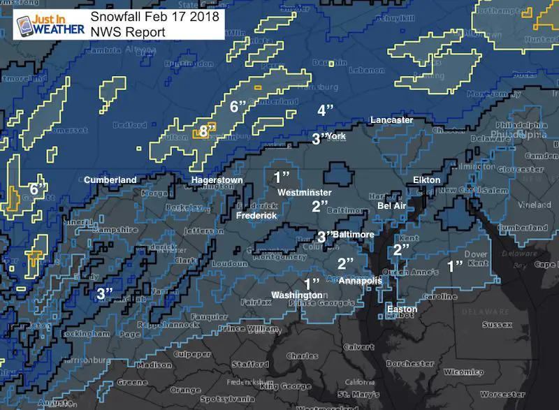
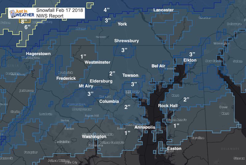
The quick hit of snow that fell across our region on Saturday February 17 was the second large snow event of the season. That is not saying much, but it did have a bigger impact than expected. The snowfall range lined up pretty well with most of my forecast, with metro areas receiving a little more stickage and accumulation. This was a tough call since the air temperature just two days earlier was in the 70s, and the 60s the day prior. But, there is a simple explanation:
Baltimore’s BWI reported 2.2 inches of snow. That is second to our 2.8″ on December 9th. The seasonal total is now 8.7 inches.
The intensity of the snowfall rate was enough to compensate for the melting on the ground. Basically it snowed so hard, it didn’t have a chance to melt before the other flakes piled up. As a result, a layer of snow let more snow stick on time and accumulate… even on the roads. That made for tough travel in more of the metro areas than I suggested during the late afternoon and evening. Just that initial intensity made the difference in an extra inch accumulating.
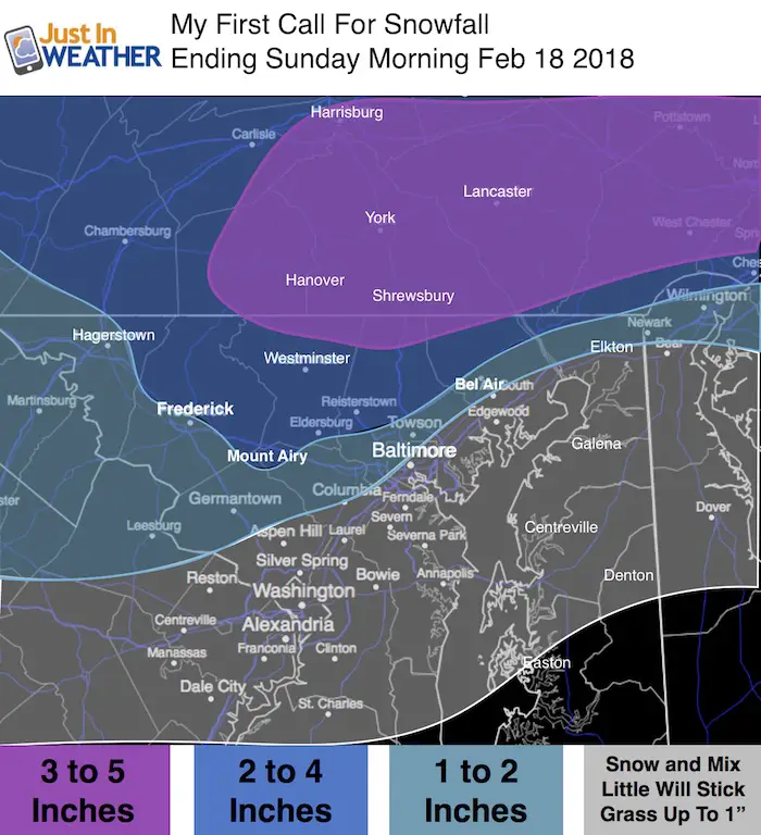
Based on this, regardless of the snow totals and timing working out well, I must grade myself a B-. See my snow forecast maps and compare to the snow reports from the National Weather Service. Please go back to the social media post where you saw this article and give me your grade for my forecast.
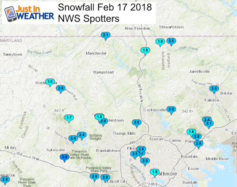
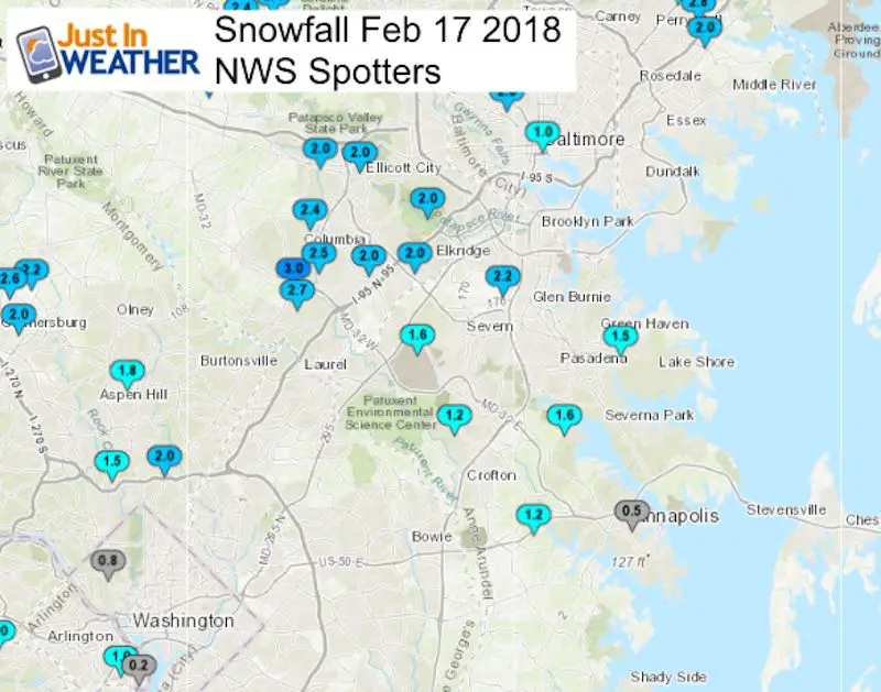
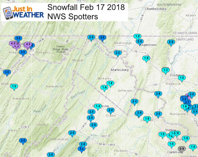
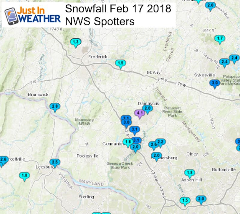
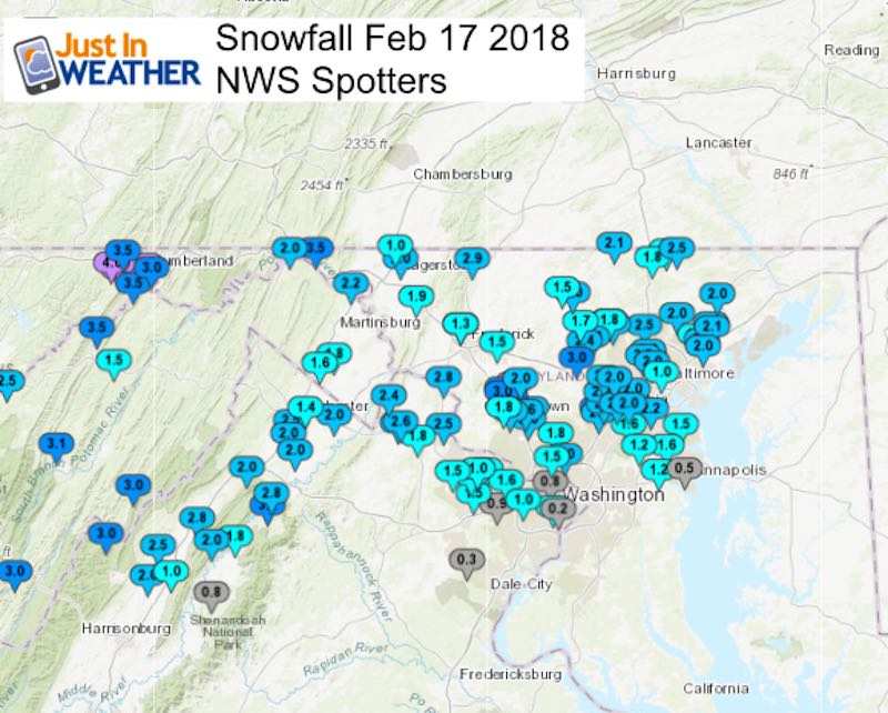
The spotter reports for the NWS Baltimore/Washington region are below.
Compare
My First Call (also my Final Call)
The snow intensity and additional inch dropped my snow bands about 30 miles to the south. The exception was a dry pocket in eastern Frederick and northwestern Carroll Counties. This was seen on the HRRR model ahead of time. Once again, the NAM 3 Km Model preformed the best here.
National Weather Service Snow Totals
See the local maps and spotter list below
L❄️VE Snow ❤️
Over $5,000 has already been raised. THANK YOU! This campaign is still going on…
My Fiancée Shannon is showing off her design for our L❄️VE Shirt. Proceeds help the start-up of our new wellness program for Pediatric Oncology Patients. The big announcement is just two weeks away. Click here or on the photo to see more…
Multiple Styles: Ladies Performance, Unisex, Kids, and two types of Hoodies

Local NWS Spotter Report Maps
See the list of reports below
********************STORM TOTAL SNOWFALL********************

LOCATION          STORM TOTAL     TIME/DATE   COMMENTS
                     SNOWFALL           OF
                     /INCHES/   MEASUREMENT

DISTRICT OF COLUMBIA

...District of Columbia...
   American University    0.8   800 PM  2/17  Broadcast Media

MARYLAND

...Allegany County...
   Ridgeley 1 W           5.0   730 PM  2/17  Trained Spotter
   Ridgeley 1 NW          4.5  1120 PM  2/17  Trained Spotter
   Frostburg 2 ESE        4.5   614 PM  2/17  Trained Spotter
   Frostburg 2 ENE        4.0  1252 AM  2/18  Trained Spotter
   Frostburg              4.0   900 PM  2/17  Trained Spotter
   Brady 1 W              3.5   830 PM  2/17  Trained Spotter
   Mount Savage           3.5   618 PM  2/17  Trained Spotter
   Cumberland             3.0   655 PM  2/17  Co-Op Observer

...Anne Arundel County...
   Bwi Airport            2.2  1200 AM  2/18  Airport
   Fort Meade 2 N         1.6   538 PM  2/17  Trained Spotter
   Herald Harbor 1 NW     1.6   800 PM  2/17  Trained Spotter
   Green Haven 1 ESE      1.5   656 PM  2/17  Trained Spotter
   Crownsville 3 SSW      1.2   958 PM  2/17  Trained Spotter
   Odenton 1 WNW          1.2   500 PM  2/17  Trained Spotter
   Annapolis 1 NW         0.5   510 PM  2/17  Trained Spotter

...Baltimore County...
   Perry Hall 2 E         2.8   855 PM  2/17  Trained Spotter
   Brooklandville 2 NNW   2.5   730 PM  2/17  Trained Spotter
   Kingsville 1 NE        2.4   949 PM  2/17  Trained Spotter
   Kingsville 1 E         2.1   900 PM  2/17  Trained Spotter
   Long Green 2 NW        2.0   730 PM  2/17  Trained Spotter
   Catonsville 1 SSE      2.0   700 PM  2/17  Trained Spotter
   Glyndon 1 WSW          2.0   900 PM  2/17  Trained Spotter
   Reisterstown           2.0   755 PM  2/17  County Emrg Mgmt
   White Marsh 1 ENE      2.0   833 PM  2/17  Trained Spotter
   Norrisville 3 W        1.8   714 PM  2/17  Trained Spotter
   Perry Hall 1 NNE       1.8   940 PM  2/17  Trained Spotter
   Bentley Springs 1 E    1.8   800 PM  2/17  Trained Spotter
   Glyndon 1 SW           1.8   656 PM  2/17  Trained Spotter

...Baltimore City...
   Pikesville 3 SE        2.8   958 PM  2/17  Trained Spotter
   Pikesville 2 SE        2.6   800 PM  2/17  CoCoRaHS
   Lochearn 2 ENE         2.5   834 PM  2/17  Trained Spotter
   Arlington 2 ESE        2.0   739 PM  2/17  Broadcast Media
   Baltimore              1.0   700 PM  2/17  Broadcast Media

...Carroll County...
   Oakland                2.4   830 PM  2/17  Trained Spotter
   Eldersburg 1 SE        2.4   815 PM  2/17  Trained Spotter
   Lineboro 2 E           2.1   904 PM  2/17  Trained Spotter
   Westminster 2 SE       2.0   659 PM  2/17  Trained Spotter
   Gamber 1 WNW           1.7   845 PM  2/17  NWS Employee
   Westminster 1 W        1.5   738 PM  2/17  CoCoRaHS

...Frederick County...
   Thurmont 3 N           2.9   815 PM  2/17  NWS Employee
   Point Of Rocks 1 NE    2.8   851 PM  2/17  Trained Spotter
   Frederick 3 NW         2.1   800 PM  2/17  NWS Employee
   New Market 2 NW        1.5   700 PM  2/17  NWS Employee
   Bloomfield 2 WSW       1.3   625 PM  2/17  Trained Spotter

...Harford County...
   Norrisville 1 WSW      2.5   852 PM  2/17  CoCoRaHS
   Bynum 1 SW             2.0   930 PM  2/17  Trained Spotter

...Howard County...
   Gaither 2 SE           3.0   715 PM  2/17  CoCoRaHS
   Simpsonville           3.0   135 AM  2/18  Trained Spotter
   Simpsonville 1 SSE     2.7   708 PM  2/17  Trained Spotter
   Columbia               2.5   830 PM  2/17  NWS Employee
   Columbia 2 N           2.4   900 PM  2/17  Trained Spotter
   Ellicott City 1 NW     2.0   628 PM  2/17  Trained Spotter
   Elkridge 2 W           2.0   708 PM  2/17  Trained Spotter
   Ellicott City 2 ENE    2.0   805 PM  2/17  Trained Spotter
   Elkridge               2.0   842 PM  2/17  NWS Employee

...Montgomery County...
   Damascus 3 SSW         4.1   657 PM  2/17  Co-Op Observer
   Clarksburg 1 N         3.1   834 PM  2/17  Other Federal
   Clarksburg 2 SE        3.1   630 PM  2/17  Trained Spotter
   Germantown 1 NE        3.1   635 PM  2/17  NWS Employee
   Clarksburg             3.0   630 PM  2/17  Broadcast Media
   Montgomery Village 1   2.6   745 PM  2/17  CoCoRaHS
   Montgomery Village 2   2.2   735 PM  2/17  Trained Spotter
   Germantown 1 ESE       2.0   800 PM  2/17  NWS Employee
   Damascus               2.0   555 PM  2/17  County Emrg Mgmt
   Four Corners 1 NNW     2.0   526 PM  2/17  Trained Spotter
   Gaithersburg 2 ENE     2.0   707 PM  2/17  Trained Spotter
   Norbeck 1 ESE          1.8   800 PM  2/17  Trained Spotter
   Germantown 1 NW        1.8   654 PM  2/17  Trained Spotter
   Kensington             1.5   755 PM  2/17  County Emrg Mgmt

...Washington County...
   Pecktonville 3 NNW     3.5   745 PM  2/17  NWS Employee
   Long Meadow 1 SSE      2.0   736 PM  2/17  Trained Spotter
   Hancock                2.0   800 PM  2/17  Trained Spotter
   Boonsboro 3 NNE        1.9   800 PM  2/17  Trained Spotter
   Maugansville 1 NE      1.0   821 PM  2/17  Airport
Please share your thoughts, best weather pics/video, or just keep in touch via social media
-
Facebook: Justin Berk, Meteorologist
-
Twitter: @JustinWeather
-
Instagram: justinweather
Keep In Touch All Winter
Click here to sign up for email alerts…. Just in case you don’t get the post on your social media feed
Snowstix- We Need You To Measure Snow Too
We are giving 10% of each sale to programs that benefit pediatric oncology patients.

 Get the award winning Kid Weather App I made with my oldest son and support our love for science, weather, and technology. Our 3 year anniversary of the release and our contribution to STEM education is this November. It has been downloaded in 60 countries, and works in both temperature scales. With your support we can expand on the fun introduction to science and real weather.
Keep In Touch All Winter
Click here to sign up for email alerts…. Just in case you don’t get the post on your social media feed
Also See:
My Winter Outlook 2017-2018 for more snow
La Nina Formed: What it could mean to our winter
NOAA Winter Outlook: Not The Best But Not The Worst For Snow
Two Farmers Almanacs Winter 2018 Outlooks
Winter Weather Folkore: Suggestions from Animals and Crops
First Frost and Freeze Dates For Maryland (southern PA and northern VA)
My Preliminary Winter Outlook Notes
Low Snow Winters In Baltimore: To Repeat Or Not Repeat
NOAA Ranks Blizzard 2016 4th Worst Snowstorm On Record
Blizzard 2016 Record Top Snowstorm: Area Totals
Extreme Weather of 2015 balanced out on both ends