 Saturday February 17 2018
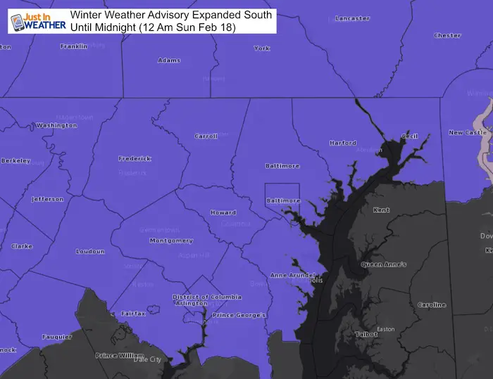
The Winter Weather Advisory has been expanded south to include Annapolis, more of central Maryland and Washington DC. The thing about this storms is that is has come in faster. This was discussed in my prior reports, but this time it raced in the burst of snow to time out with sunset and allow for some brief cooling and stickage. The system will also pull in warmer air north and race out of hear before midnight. The snow line is what should be watched closely over the next few hours. Many places are right on the fence with temperatures and if the snow rates can cool the ground fast enough to lay and stay.
I still see melting in metro areas but moderate snow and more problems in the normally colder suburbs to the north and west. I also see the same snow totals as I had mentioned before. See my map and compare to NWS forecasts below the radar simulation.
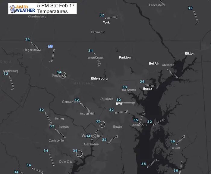
Temperatures and Wind at 5 PM
The hourly report had BWI Airport at 32ºF with HEAVY SNOW! Meanwhile it was 34ºF in Frederick. This was all about the intensity of the snow causing the temps to drop.
The interesting thing at this hour is that we have an easterly wind. That normally will feed in warmer air off of the Chesapeake Bay and turn snow over to a mix or rain in metro area. The snow intensity is battling that and dragging down colder air from aloft. This was mentioned in my prior reports, but the intensity has been winning the battle. So some roads have gotten snow despite the 70ºF temps we had two days ago.
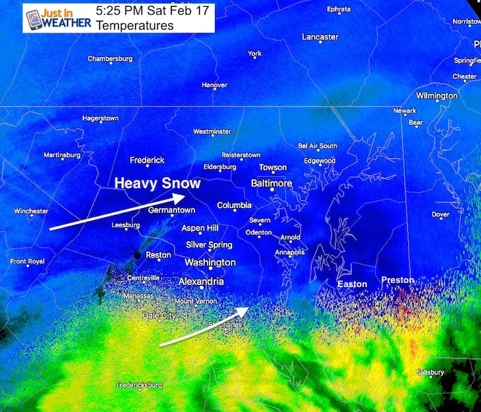
Doppler Radar
At 5:25 PM There was a band of Heavy Snow from Baltimore to Eldersburg and Mount Airy. But less to the north in a pocket from the south side of Westminster and Parkton and Conowingo. The snow appears to have also hit Easton and Preston on the Eastern Shore.
To Honor The Snow…
FITF SALE TODAY ONLY
All FITF Gear is 17% off to honor this date with snow
Enter the Promo Code: snow17
This includes all classic and new designs. Click the image to get started.

Radar Simulation
—> slider
The modeling suggests the warmer air will mix in and shift north one the next two hours. This will be interesting to see where the mix over is. But where it is snowing moderately, the roads will cool quickly and may cover over.
[metaslider id=58168]
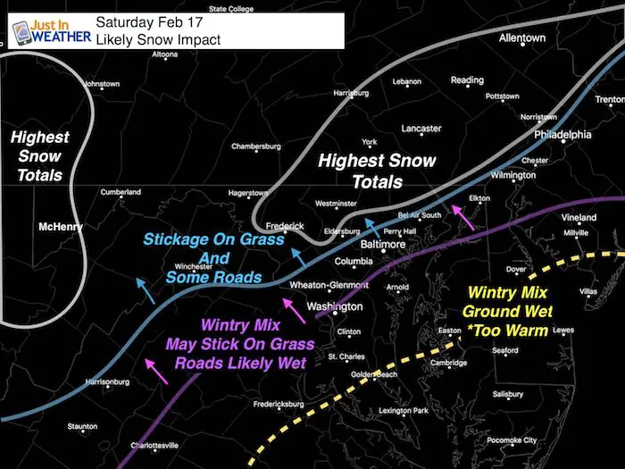
Snow Impact: Where will it stick and accumulate?
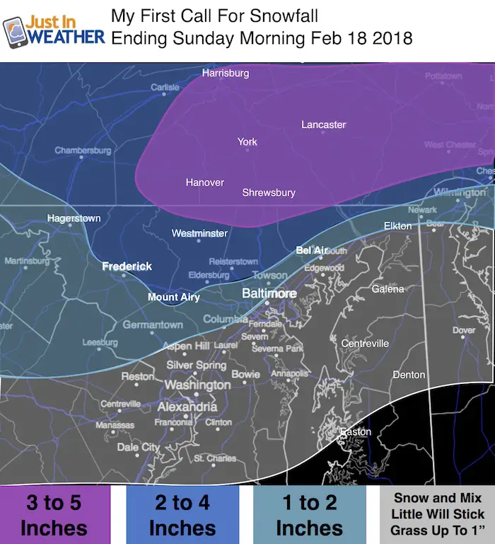
This is the map I have shown in may prior two posts. I still stand by this as it lines up with where the freezing line will reach and climatologically favored colder places are. The blue line has been shifted south close to whew the purple line is for some road issues.
My Original Call for Snowfall Frost Posted Friday Morning
- Far northern suburbs 3 to 5 inches. This is near and north of the Pennsylvania line into York and Lancaster. The best area for stickage and icy roads Sunday morning.
- 2 to 4 inches much of Frederick (north of the city), Carroll, Baltimore, Hartford (north of Bel Air)
- 1 to 2 inches in metro areas near ad west of I-95 (away from the Bay), but most roads stay wet! Might get icy Sunday morning.
- Mixed snow and sleet south, but the ground is too warm for stickage
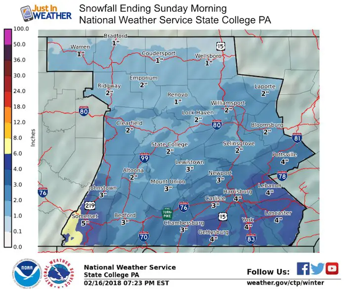
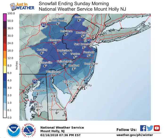
Snowfall Forecast Maps
National Weather Service Regional Zone Maps
Notes:
NWS has increased these totals a little but still in the same general set up as listed below (which I posted earlier as well)
- Northern suburbs 2 to 4 inches- The best area for stickage and icy roads Sunday morning.
- General 1 to 2 inches in metro areas, but most roads stay wet!
- Mixed snow and sleet south, but the ground is too war for stickage
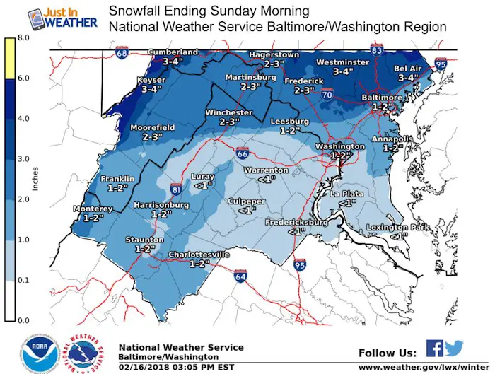
Note: Winter Storm Warnings are in effect for the northern suburbs of Philadelphia. Snow in Cecil County and northern Delmarva has increased here but will still battle the warm ground.
L❄️VE Snow ❤️Also 17% off today
Use Promo Code: snow17
SALE on ALL FITF items All DAY SATURDAY! Use Promo Code: snow 17 for 17% to honor the date of our snow ?
Over $5,000 has already been raised. THANK YOU! This campaign is still going on…
My Fiancée Shannon is showing off her design for our L❄️VE Shirt. Proceeds help the start-up of our new wellness program for Pediatric Oncology Patients. The big announcement is just two weeks away. Click here or on the photo to see more…
Multiple Styles: Ladies Performance, Unisex, Kids, and two types of Hoodies

Please share your thoughts, best weather pics/video, or just keep in touch via social media
-
Facebook: Justin Berk, Meteorologist
-
Twitter: @JustinWeather
-
Instagram: justinweather
Keep In Touch All Winter
Click here to sign up for email alerts…. Just in case you don’t get the post on your social media feed
Snowstix- We Need You To Measure Snow Too
We are giving 10% of each sale to programs that benefit pediatric oncology patients.

 Get the award winning Kid Weather App I made with my oldest son and support our love for science, weather, and technology. Our 3 year anniversary of the release and our contribution to STEM education is this November. It has been downloaded in 60 countries, and works in both temperature scales. With your support we can expand on the fun introduction to science and real weather.
Keep In Touch All Winter
Click here to sign up for email alerts…. Just in case you don’t get the post on your social media feed
Also See:
My Winter Outlook 2017-2018 for more snow
La Nina Formed: What it could mean to our winter
NOAA Winter Outlook: Not The Best But Not The Worst For Snow
Two Farmers Almanacs Winter 2018 Outlooks
Winter Weather Folkore: Suggestions from Animals and Crops
First Frost and Freeze Dates For Maryland (southern PA and northern VA)
My Preliminary Winter Outlook Notes
Low Snow Winters In Baltimore: To Repeat Or Not Repeat
NOAA Ranks Blizzard 2016 4th Worst Snowstorm On Record
Blizzard 2016 Record Top Snowstorm: Area Totals
Extreme Weather of 2015 balanced out on both ends