 Wednesday February 7 2018
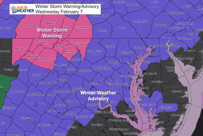
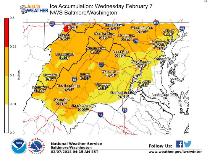
The arrival of the wintry mix is on schedule beginning in most areas during the 5 AM hour… which is as I write this. Many school districts have delayed their start time, and I expect they will reevaluate the situation after sunrise. The Winter Storm Warning remains for a heavy ice storm in the mountains, and the Winter Weather Advisory has been expanded to Calvert and Dorchester Counties due to the temperatures down around freezing.
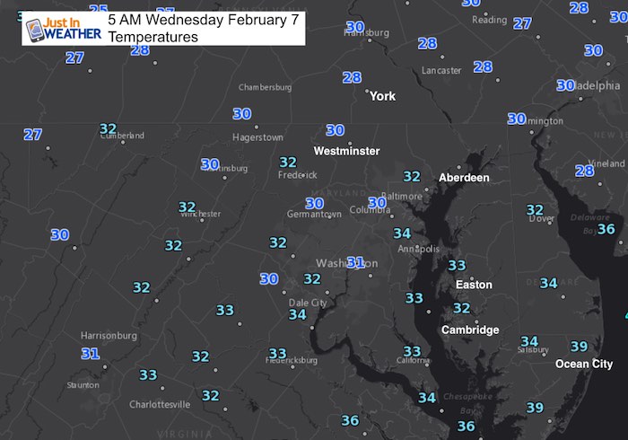
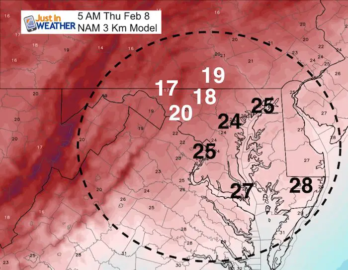
5 AM Temperatues
Below is a look at the ice timeline and key time frames for temperatures. There are a few things I want to point out with the storm:
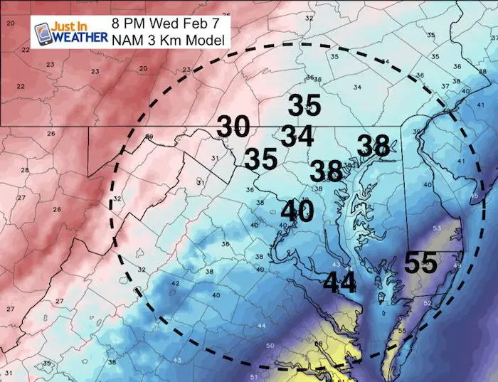
- Temperatures tend to drop a degree or two as the precipitation begins.
- The ground is a little colder than the air temperature. So as we start to thaw, the thermometers will read above 32ºF before the ground feels it.
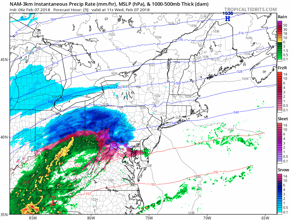
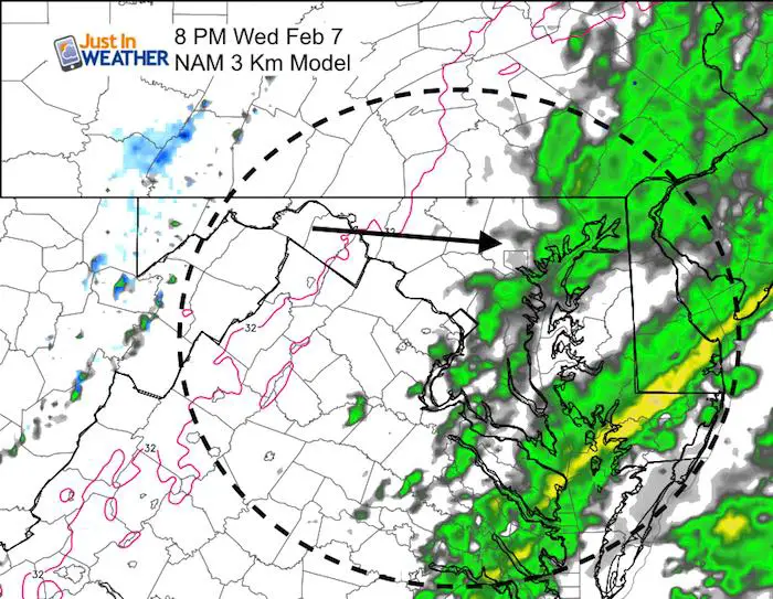
- There will be a few hours of snow/sleet/freezing rain this morning with a break possible. That is the upper level warm front at cloud level. Then the main band of precipitation will move in later this morning
- Snow accumulation will be minimal but colder areas that got it Sunday could get another 1 to 2 inches this morning. The ice accumulation is the biggest threat!
- Schools likely to reevaluate delay vs. closing during the morning
- The thaw time is very difficult and not region wide. It will be a slow process and in your town you may turn the corner and go from wet back to ice covered roads.
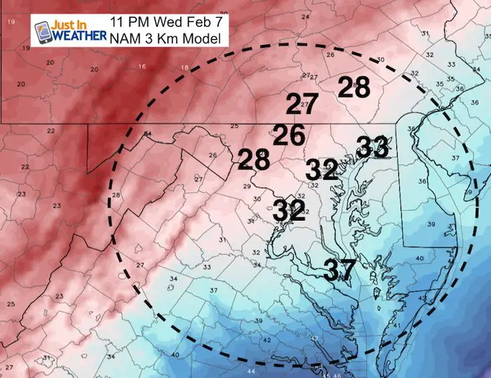
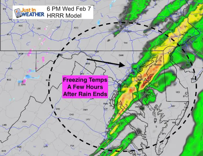
- The rain will end this evening and the freezing air will come back a few hours later. That will be the race between drying and freezing for more possible ice tomorrow morning.
- Salt will wash away, some a fresh drop would be needed.
See Live Interactive Radar Here
Stats For February 7
Normal High: 43ºF
Record High: 72ºF in 2017
Normal Low: 25ºF
*Former Record Low: +6ºF in 1895
Snow Record: 10.1″ in 1967
Seasonal Snow To Date (at BWI): 6.5″
Sunrise: 7:07 AM
Sunset 5:34 PM
*Daylight = 2:14 longer than yesterday
*Bay Water Temperature = 34ºF at Thomas Pt. Light House
Keep In Touch All Winter
Click here to sign up for email alerts…. Just in case you don’t get the post on your social media feed
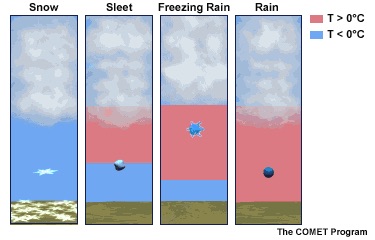
Also see: What is Winter Precipitation: Snow, Sleet, and Freezing Rain
NAM 3 Km Model Animation
Radar Simulation Close View
Compare Two Model Timelines
—> NAM 3 KM Model Slider
Notice the break this morning as the first wave of ice moves north and then the rain arrives from the west. The push of warmer air should consider the frozen ground and some leftover ice for an extra hour to two.
[metaslider id=57780]
Ice Accumulation
End Of The Rain
Temperatures: ReFreeze
The return of the freezing air will be at least 2 hours after the rain ends… The race between drying and icing on roads…
Morning Chill
Most areas will be well below freezing Thursday morning
—> HRRR Model Slider
[metaslider id=57762]
End Of The Rain
This shows the end of the rain a few hours early, and the return of freezing air a few hours later.
L❄️Ve Snow ❤️
We’ve added KIDS SIZES and HOODIES
My Fiancée Shannon is showing our L❄️VE Shirt. Order this week and these will arrive in your hands before Valentines Day. Proceeds help the start-up of our new program for Pediatric Oncology Patients. The big announcement is just two weeks away. Click here or on the photo to see more…

Please share your thoughts, best weather pics/video, or just keep in touch via social media
-
Facebook: Justin Berk, Meteorologist
-
Twitter: @JustinWeather
-
Instagram: justinweather
Keep In Touch All Winter
Click here to sign up for email alerts…. Just in case you don’t get the post on your social media feed
 Get the award winning Kid Weather App I made with my oldest son and support our love for science, weather, and technology. Our 3 year anniversary of the release and our contribution to STEM education is this November. It has been downloaded in 60 countries, and works in both temperature scales. With your support we can expand on the fun introduction to science and real weather.
Snowstix- We Need You To Measure Snow Too
We are giving 10% of each sale to programs that benefit pediatric oncology patients.

FITF Gear

Keep In Touch All Winter
Click here to sign up for email alerts…. Just in case you don’t get the post on your social media feed
Also See:
My Winter Outlook 2017-2018 for more snow
La Nina Formed: What it could mean to our winter
NOAA Winter Outlook: Not The Best But Not The Worst For Snow
Two Farmers Almanacs Winter 2018 Outlooks
Winter Weather Folkore: Suggestions from Animals and Crops
First Frost and Freeze Dates For Maryland (southern PA and northern VA)
My Preliminary Winter Outlook Notes
Low Snow Winters In Baltimore: To Repeat Or Not Repeat
NOAA Ranks Blizzard 2016 4th Worst Snowstorm On Record