 Sunday February 4 2018
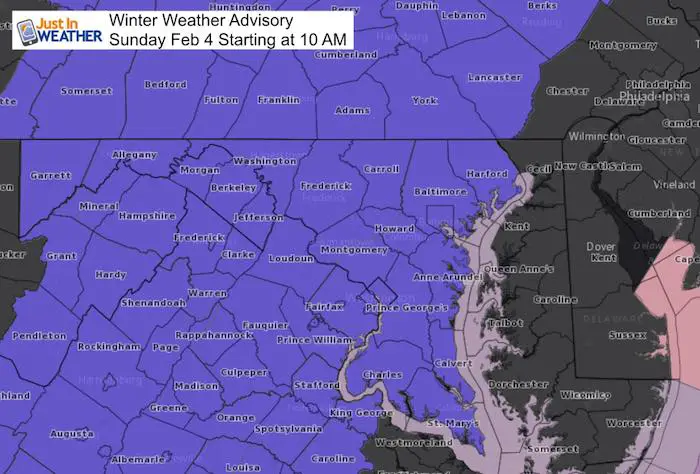
The Winter Weather Advisory now includes more of central Maryland and east to York and Lancaster County PA. This is what I suggested in my report yesterday, but I see the impact being brief. The Advisory begins at 10 AM and extends into the afternoon, when the thaw will be spreading north on warmer southeasterly winds. So your plans to travel to watch the Super Bowl should be OK by mid afternoon locally. The issue we have this morning is that the ground is cold and temperatures are near or just below freezing. The onset of the first flakes or sleet pellets will help drop the temperatures a few degrees… for only a few hours.
The solar energy from daylight will help to warm the pavement and thaw any quick icing… But that transition will be slower farther north and in deeper valleys that are sheltered. See the break down and timeline below:
Stats For February 4
Normal High: 43ºF
Record High: 72ºF in 1991
Normal Low: 25ºF
*Former Record Low: +5ºF in 1918
Snow Record: 7.2″ in 1995
Seasonal Snow To Date (at BWI): 6.5″
Sunrise: 7:10 AM
Sunset 5:30 PM
*Daylight = 2:10 longer than yesterday
*Bay Water Temperature = 34ºF at Thomas Pt. Light House
Keep In Touch All Winter
Click here to sign up for email alerts…. Just in case you don’t get the post on your social media feed
Morning Set Up
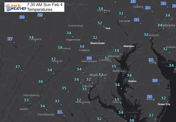
Note the temperatures are not that cold… There are only a few spots at or below 32ºF. The onset of snow and sleet should drop the temps a few degrees and the pavement is cold. However the cold air is not that deep, so I do not expect this to stick around more than a few hours for most of our region.
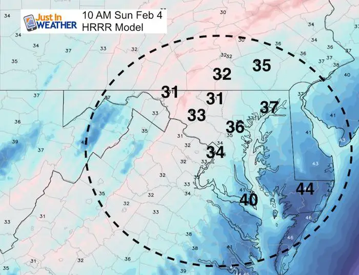
—> slider: Radar Simulation
This is the HRRR Model, showing the transition a little faster than the NAM 3 KM
[metaslider id=57603]
The thaw transition is a little faster on the HRRR Model than the NAM 3 Km (shown below). The difference is about 2 to 3 hours in some spots. So considering that time window for the likelihood for improvement on the roads.
Compare to the NAM 3 Km Model at Noon
This holds the cold a little longer.
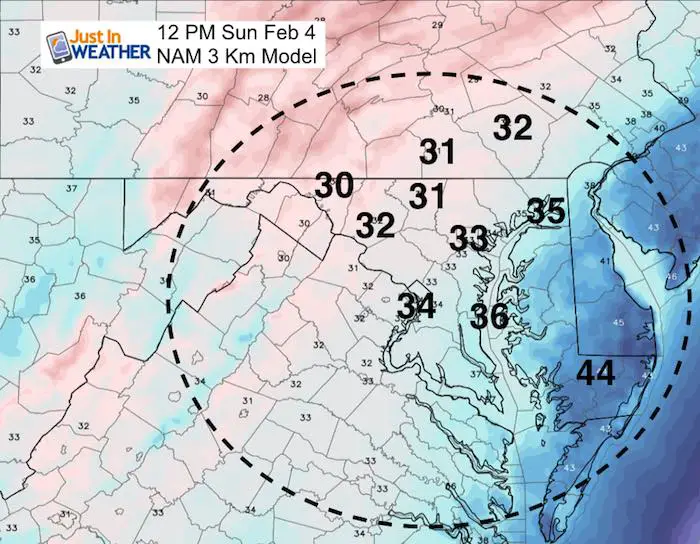
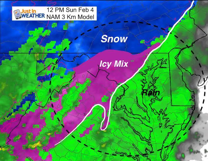
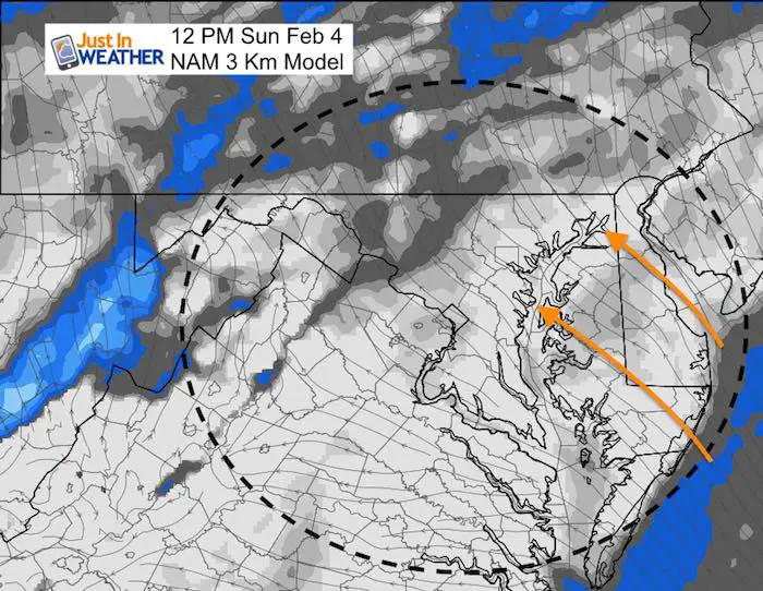
The Wind Flow from the South to Southeast is the key to warming up the region. The air source across lower Delmarva will be in the mid 40s at noon and send that north.
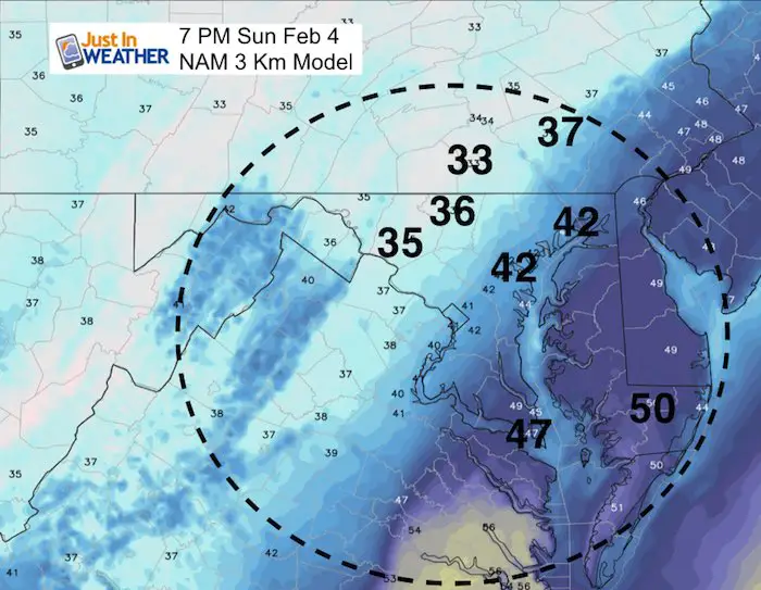
Evening Thaw:
Outlook
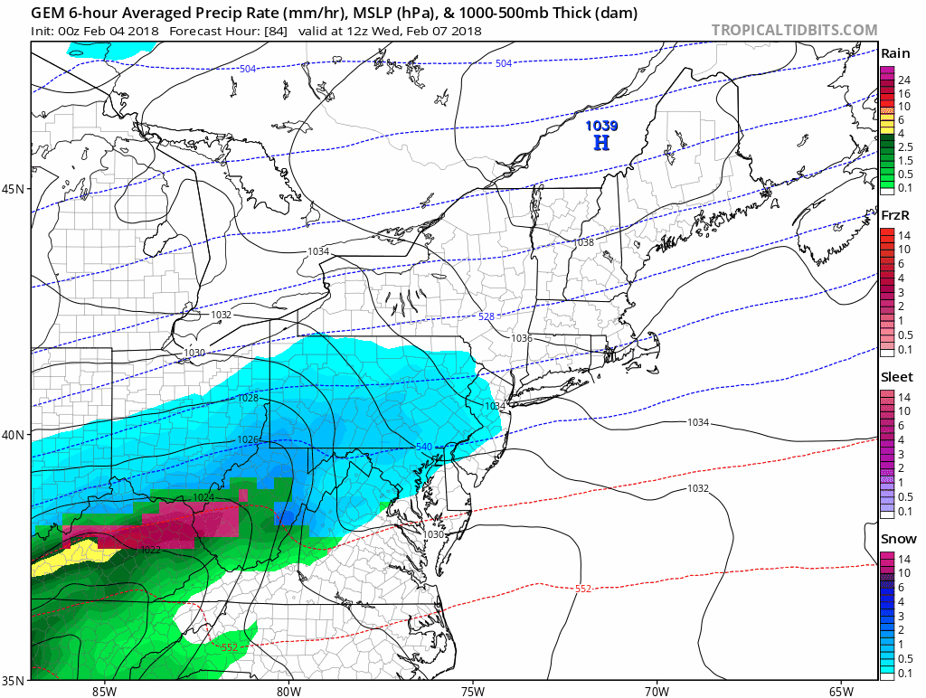
Considering the colder result of this event, I want to show the Canadian GEM model for the next event. This is a colder solution that shows possible snow and icy mix Wednesday and Thursday. We are expecting to have a warm up mid month before Valentines Day, then cool down again by the 20th.
May The Flakes Be With You- Limited Edition Shirt
A Portion of the proceeds will go to Integrated Wellness programs for Pediatric Oncology Patients

Please share your thoughts, best weather pics/video, or just keep in touch via social media
-
Facebook: Justin Berk, Meteorologist
-
Twitter: @JustinWeather
-
Instagram: justinweather
Keep In Touch All Winter
Click here to sign up for email alerts…. Just in case you don’t get the post on your social media feed
 Get the award winning Kid Weather App I made with my oldest son and support our love for science, weather, and technology. Our 3 year anniversary of the release and our contribution to STEM education is this November. It has been downloaded in 60 countries, and works in both temperature scales. With your support we can expand on the fun introduction to science and real weather.
Snowstix- We Need You To Measure Snow Too
We are giving 10% of each sale to programs that benefit pediatric oncology patients.

FITF Gear

Keep In Touch All Winter
Click here to sign up for email alerts…. Just in case you don’t get the post on your social media feed
Also See:
My Winter Outlook 2017-2018 for more snow
La Nina Formed: What it could mean to our winter
NOAA Winter Outlook: Not The Best But Not The Worst For Snow
Two Farmers Almanacs Winter 2018 Outlooks
Winter Weather Folkore: Suggestions from Animals and Crops
First Frost and Freeze Dates For Maryland (southern PA and northern VA)
My Preliminary Winter Outlook Notes
Low Snow Winters In Baltimore: To Repeat Or Not Repeat
NOAA Ranks Blizzard 2016 4th Worst Snowstorm On Record
Blizzard 2016 Record Top Snowstorm: Area Totals
Extreme Weather of 2015 balanced out on both ends