 February 1 2018
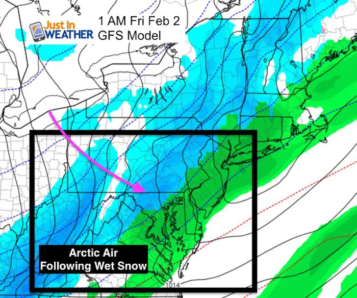
Another arctic front is on the way and will reach us Friday morning. Regardless of what Phil says for Groundhog Day, we will have a dramatic drop in temperatures, just as the rain and snow will be ending. In fact, I see rain overnight tonight turning to wet snow before our surface temperatures drop. The cold air will arrive at cloud level sooner, bringing in a brief period of wet snow that likely will melt on the roads. Some stickage may hold on the grass but that is not the issue. Our problem will be with the flash freeze, or quick icing before sunrise as arctic air surely follow in a hurry.
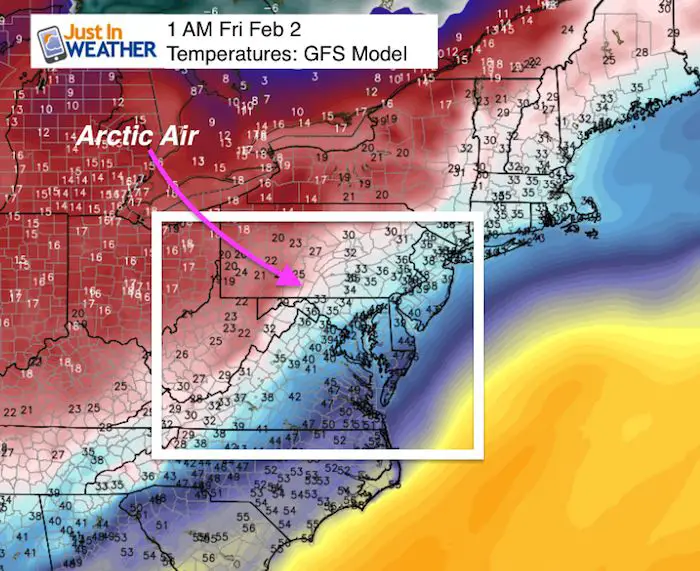
Here is a look at the high resolution NAM 3 Km model to compare the transition to snow and the freezing line. There are two sliders below with hourly plots. The first shows the radar simulation and freezing line. The second shows expected temperatures. The quick drop into the 20s and teens will be before sunrise west of the Chesapeake Bay and soon enough to act on the wet pavement. What is not treated with salt will ice up and make for potentially dangerous travel for a few hours. Please use caution and know this will be a tough call for area schools.
Note: Our areas was just issued a Drought Watch today. See more on that here. This is not a lot of moisture but enough to be a problem
—> sliders
Radar Simulation
Note: The ‘wet’ snow seen in blue indicates where snow will fall from colder clouds but the ground will still be above 32ºF. The snow will help to cool the ground and may stick in some areas sooner than others.. That will help set up the rapidly moving colder air to follow. I have highlighted the towns that should be dropping below freezing in the hourly plot shown to help track the potential icing.
[metaslider id=57486]
Hourly Temperature Plots
The freezing air should be in place in all metro areas by 6 AM. This is within 2 hours of the snow ending, and the wet snow will help to chill the pavement along the way. That is enough time for residual wet pavement to ice up in a hurry, especially in places that drop into the 20s. By sunrise (7:12 AM), the freezing line will cross the Bay Bridge and into southern Maryland.
[metaslider id=57501]
There is no promise of road conditions or school responses to the weather. Please check back for another update this evening and early Friday morning. We still have to closely watch the snow on Sunday as some of our region may stay mostly snow and have travel problems through the Super Bowl and into Monday morning.
Please share your thoughts, best weather pics/video, or just keep in touch via social media
-
Facebook: Justin Berk, Meteorologist
-
Twitter: @JustinWeather
-
Instagram: justinweather
Keep In Touch All Winter
Click here to sign up for email alerts…. Just in case you don’t get the post on your social media feed
 Get the award winning Kid Weather App I made with my oldest son and support our love for science, weather, and technology. Our 3 year anniversary of the release and our contribution to STEM education is this November. It has been downloaded in 60 countries, and works in both temperature scales. With your support we can expand on the fun introduction to science and real weather.
May The Flakes Be With You- Limited Edition Shirt
A Portion of the proceeds will go to Integrated Wellness programs for Pediatric Oncology Patients

Snowstix- We Need You To Measure Snow Too
We are giving 10% of each sale to programs that benefit pediatric oncology patients.

FITF Gear

Keep In Touch All Winter
Click here to sign up for email alerts…. Just in case you don’t get the post on your social media feed
Also See:
My Winter Outlook 2017-2018 for more snow
La Nina Formed: What it could mean to our winter
NOAA Winter Outlook: Not The Best But Not The Worst For Snow
Two Farmers Almanacs Winter 2018 Outlooks
Winter Weather Folkore: Suggestions from Animals and Crops
First Frost and Freeze Dates For Maryland (southern PA and northern VA)
My Preliminary Winter Outlook Notes
Low Snow Winters In Baltimore: To Repeat Or Not Repeat
NOAA Ranks Blizzard 2016 4th Worst Snowstorm On Record