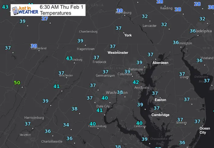
 Thursday February 1 2018
We have a new month and we are about the get a new storm pattern. The problem is that while it will turn colder and more active, the storm track will keep the snow and rain line very close. This is by no way a lock and one reason I hesitate with showing computer model plots because I am certain the track of the storm on the way will wobble a bit. There are a few things to track and the first will be Friday morning’s cold front. While rainFebruary 1 temperatures tonight will end as snow in the morning, the timing of the cold air is my primary concern. That will be Groundhog Day and we could have a clue at what Phill may say. Then we can work on the Super Bowl Sunday storm.
Stats For February 1
Normal High: 42ºF
Record High: 75ºF in 2002
Normal Low: 25ºF
*Former Record Low: +7ºF in 1965
Snow Record: 9.0″ in 1934
Seasonal Snow To Date (at BWI): 6.5″
Sunrise: 7:13 AM
Sunset 5:27 PM
*Daylight = 2:04 longer than yesterday
*Bay Water Temperature = 35ºF at Thomas Pt. Light House
Keep In Touch All Winter
Click here to sign up for email alerts…. Just in case you don’t get the post on your social media feed
This Afternoon:
Look for highs near 50ºF and increasing clouds with late day or evening rain showers…
Overnight
After a mild day, rain will arrive this evening and tonight. The cold front will bring in a change to snow, but the colder air will reach cloud level a few hours before reaching the ground. Stickage will be minimal and most likely on the grass. But, freezing temps drop into the 20s between 6 and 8 AM, which may ice up wet roads. This will be a tough commute. Should this speed up by 1 or two hours, we may have a better chance to plan ahead for schools.
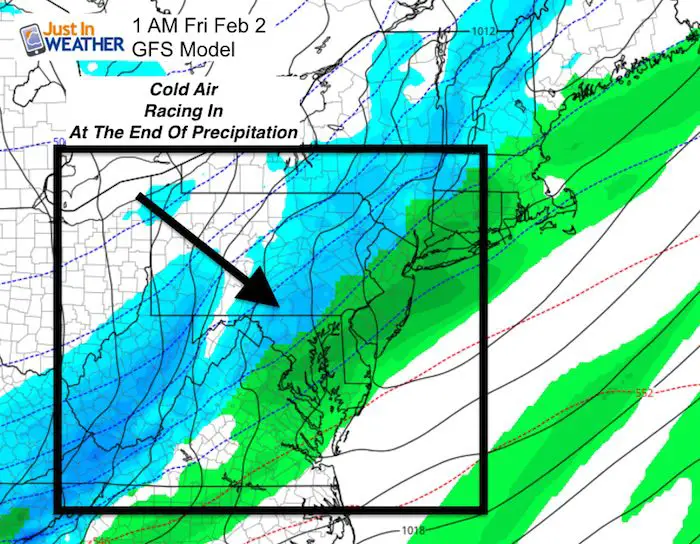
Friday Morning
Radar Simulation—> slider
[metaslider id=57453]
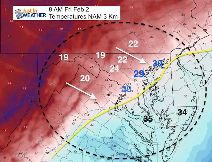
Temperatures: Flash Freeze?
This snapshot shows the quick drop of temperatures into the 20s during the morning commute
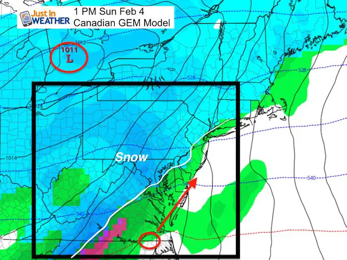
Super Bowl Sunday Storm
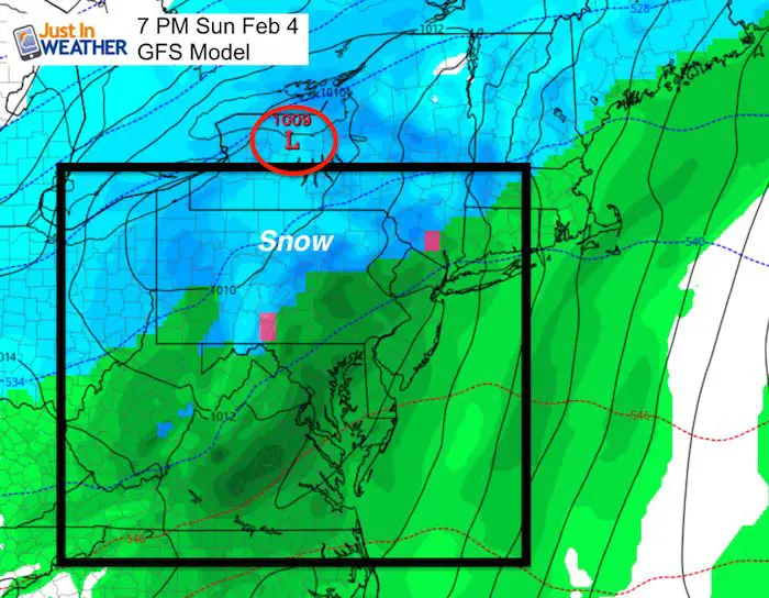
I do not subscribe the the Farmer’s Almanac claim, but there will be a storm heading our way. The problem is that despite the push of cold air Friday, we have had systems hold back and verify north. That is why the modeling for this event Sunday shows snow changing to rain. Also why the timing has shifted from Monday to Sunday.
*A reminder that mid and long range computer modeling is just a gauge but still rather poor in locking in storms more than 3 or 4 days away.
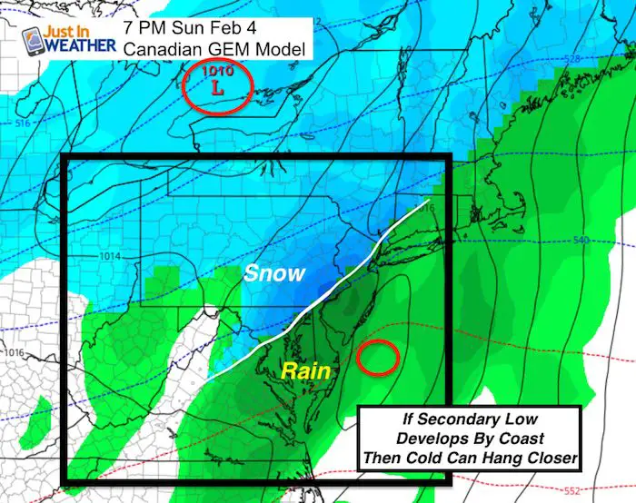
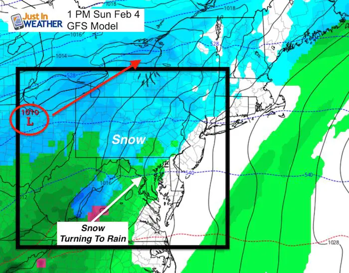
The hope for snow lovers is for a secondary Low Pressure to form along the coast that would hold the cold in place for some. That is the difference between the Canadian and GFS Models here. After the next model run this morning, I will give my take as to which solution I agree with. I still expect some wobbling of the timing and track from what is seen here.
Canadian Model: Secondary Low Holds The Cold
GFS Model- Single inland Low lets warmer air push farther north
Outlook
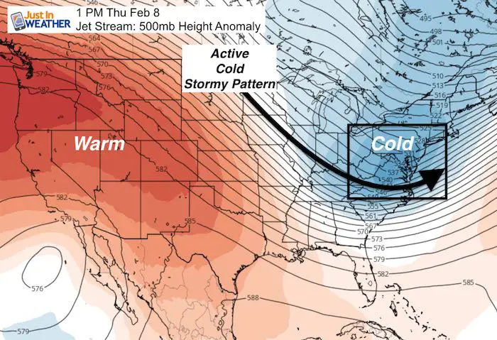
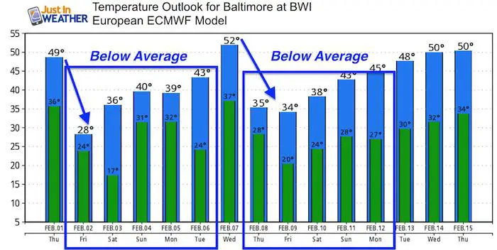
The jet stream will send more impulses of energy along with colder air over the next two weeks. Even though the modeling may not show it well, the pattern itself supports an active first half of February.
Temperature Outlook
Please share your thoughts, best weather pics/video, or just keep in touch via social media
-
Facebook: Justin Berk, Meteorologist
-
Twitter: @JustinWeather
-
Instagram: justinweather
Keep In Touch All Winter
Click here to sign up for email alerts…. Just in case you don’t get the post on your social media feed
 Get the award winning Kid Weather App I made with my oldest son and support our love for science, weather, and technology. Our 3 year anniversary of the release and our contribution to STEM education is this November. It has been downloaded in 60 countries, and works in both temperature scales. With your support we can expand on the fun introduction to science and real weather.
May The Flakes Be With You- Limited Edition Shirt
A Portion of the proceeds will go to Integrated Wellness programs for Pediatric Oncology Patients

Snowstix- We Need You To Measure Snow Too
We are giving 10% of each sale to programs that benefit pediatric oncology patients.

FITF Gear

Keep In Touch All Winter
Click here to sign up for email alerts…. Just in case you don’t get the post on your social media feed
Also See:
My Winter Outlook 2017-2018 for more snow
La Nina Formed: What it could mean to our winter
NOAA Winter Outlook: Not The Best But Not The Worst For Snow
Two Farmers Almanacs Winter 2018 Outlooks
Winter Weather Folkore: Suggestions from Animals and Crops
First Frost and Freeze Dates For Maryland (southern PA and northern VA)
My Preliminary Winter Outlook Notes
Low Snow Winters In Baltimore: To Repeat Or Not Repeat
NOAA Ranks Blizzard 2016 4th Worst Snowstorm On Record