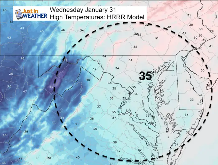
Wednesday January 31 2018
This morning is the Super Blue Blood Moon and there will be some snow soon. We are just missing the astronomical event and it seems like we keep just missing snow events too. There is colder air spilling in and we have a lot of energy to work with over the next few weeks. The problem is lining up the energy so that it can produce something for snow lovers. Each storm shown on the models appears to fade and shift a few days for another chance. I have seen this many times, and while it may look like crying wolf, eventually something will play out. That something should be within the next week.
See more on the snow outlook below
Stats For January 31
Normal High: 42ºF
Record High: 69ºF in 1947; 1916; 1914
Normal Low: 25ºF
*Former Record Low: +4ºF in 1966; 1965
Snow Record: 3.7″ in 1985
Seasonal Snow To Date (at BWI): 6.5″
Sunrise: 7:14 AM
Sunset 5:26 PM
*Daylight = 2:03 longer than yesterday
*Bay Water Temperature = 34ºF at Thomas Pt. Light House
Keep In Touch All Winter
Click here to sign up for email alerts…. Just in case you don’t get the post on your social media feed
Also see: Super Blue Blood Moon
Today:
Thursday Evening- Rain
After a temps reach near 50ºF, rain will arrive late Thursday ahead of the cold front
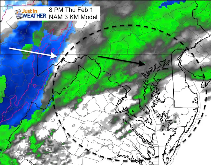
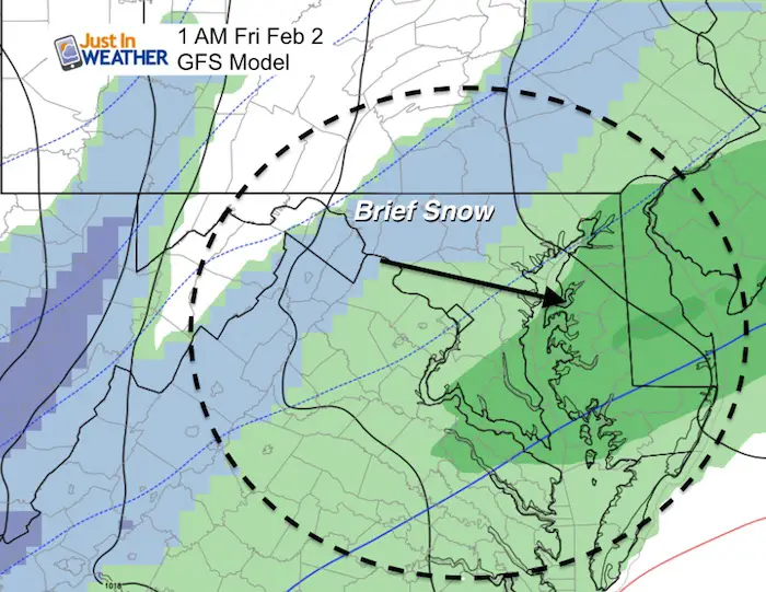
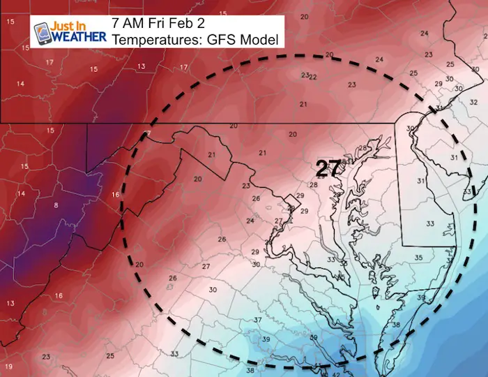
Friday Snow? Barely Again
This is not exactly a repeat of what we just had on Tuesday, but it will show cold air following a brief period of snow. That could make wet roads icy just before sunrise…
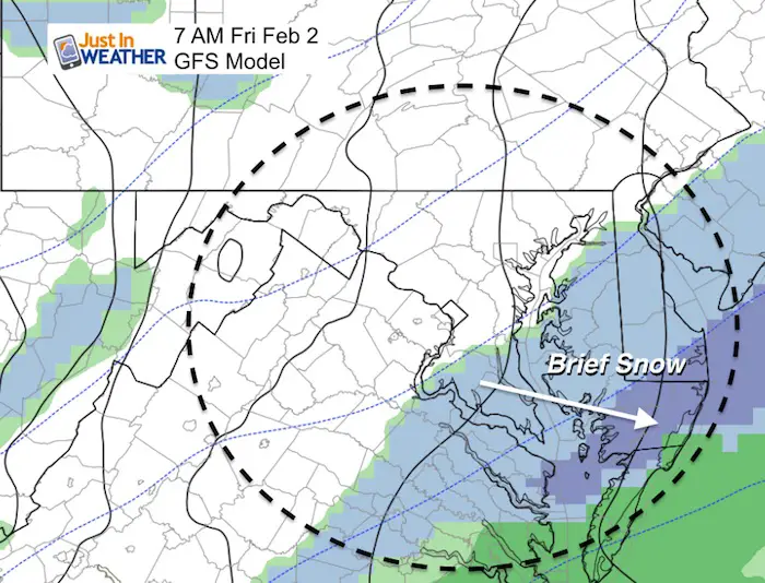
Friday Morning Low Temperatures
This is the issue that could make wet roads icy
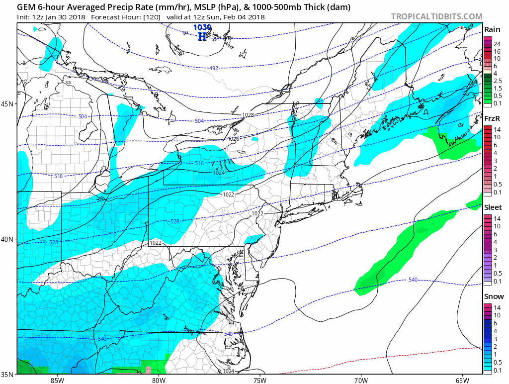
Animation: Snow Chances Sunday Through Next Week:
The model trend has been for a shift of systems north. So I can not lock into these plots as arctic air will be battling and the snowlike set up will not be clear until a day or two prior. That will also determine how much can fall, but who gets all snow will likely need to use a shovel for clearing it.
GFS Model

Canadian Model
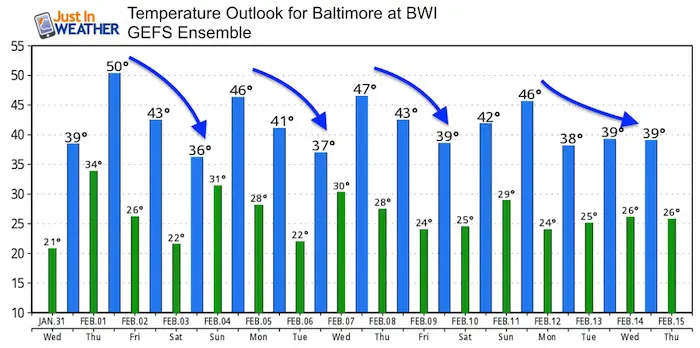
Temperature Outlook
There will be a lot of fluctuation up and down. While this does not appear to show an extended arctic outbreak, I see potential for colder air than shown here (a limitation of the model ensemble).
Please share your thoughts, best weather pics/video, or just keep in touch via social media
-
Facebook: Justin Berk, Meteorologist
-
Twitter: @JustinWeather
-
Instagram: justinweather
Keep In Touch All Winter
Click here to sign up for email alerts…. Just in case you don’t get the post on your social media feed
 Get the award winning Kid Weather App I made with my oldest son and support our love for science, weather, and technology. Our 3 year anniversary of the release and our contribution to STEM education is this November. It has been downloaded in 60 countries, and works in both temperature scales. With your support we can expand on the fun introduction to science and real weather.
May The Flakes Be With You- Limited Edition Shirt
A Portion of the proceeds will go to Integrated Wellness programs for Pediatric Oncology Patients

Snowstix- We Need You To Measure Snow Too
We are giving 10% of each sale to programs that benefit pediatric oncology patients.

FITF Gear

Keep In Touch All Winter
Click here to sign up for email alerts…. Just in case you don’t get the post on your social media feed
Also See:
My Winter Outlook 2017-2018 for more snow
La Nina Formed: What it could mean to our winter
NOAA Winter Outlook: Not The Best But Not The Worst For Snow
Two Farmers Almanacs Winter 2018 Outlooks
Winter Weather Folkore: Suggestions from Animals and Crops
First Frost and Freeze Dates For Maryland (southern PA and northern VA)
My Preliminary Winter Outlook Notes
Low Snow Winters In Baltimore: To Repeat Or Not Repeat
NOAA Ranks Blizzard 2016 4th Worst Snowstorm On Record
Blizzard 2016 Record Top Snowstorm: Area Totals
Extreme Weather of 2015 balanced out on both ends