 Friday January 26 2018
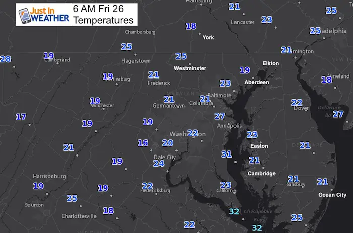
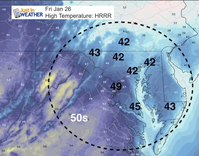
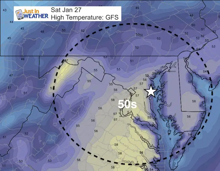
We have a very chilly morning, but the winds have eased up. A bit frosty to start and a near normal day ahead. The sunshine and lighter winds will help it feel better. Even warmer air is on the way Saturday for the bulk of Polar Bear Plunging at Sandy Point. Water temps are still in the mid 30s. Saturday is the pick of the weekend with rain on Sunday, but it won’t be a washout. More rain will fall on the lower Eastern Shore. Then we set our sights on colder air next week with two chances of snow. One will be early in the week, the other a larger storm on Groundhog Day- Friday. See more below.
Historical Note: On this date in 1950, the hottest January day in Baltimore history with a high temperature of 79ºF
Stats For January 26
Normal High: 42ºF
Record High: 79ºF in 1950*
Normal Low: 24ºF
*Former Record Low: +2ºF in 1961
Snow Record: 7.6″ in 2011
Seasonal Snow To Date (at BWI): 6.5″
Sunrise: 7:18 AM
Sunset 5:20 PM
*Daylight = 1:54 longer than yesterday
*Bay Water Temperature = 34ºF at Thomas Pt. Light House
Keep In Touch All Winter
Click here to sign up for email alerts…. Just in case you don’t get the post on your social media feed
May The Flakes Be With You- Limited Edition Shirt
A Portion of the proceeds will go to Integrated Wellness programs for Pediatric Oncology Patients

TOMORROW:
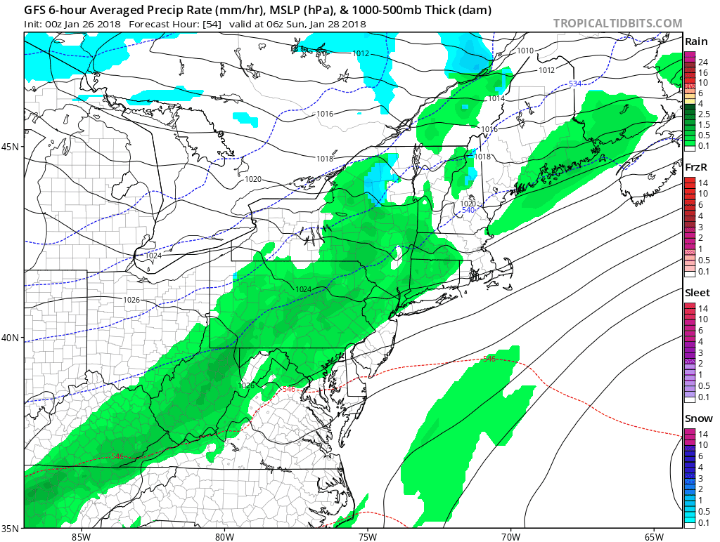
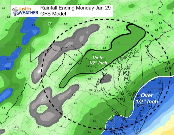
Sunday-Monday Rain
Rainfall Potential
This will not be a heavy event. Baltimore is -1.63″ for the month on rainfall, so we can every drop. The heaviest rain will be on the lower Eastern Shore as Low Pressure will form off of the coast and stall the front longer there.
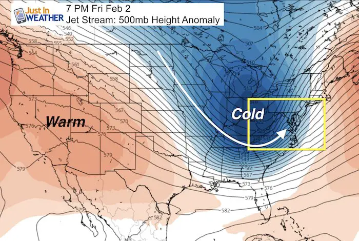
Snow Next Week?
TUESDAY
A small disturbance will follow the weekend rain and bring a chance for snow to the area Monday night into Tuesday morning. The trend for systems like this is the verify a little farther north…. So I noted that here to indicate the potential for this to exported north of Baltimore into Southern PA.
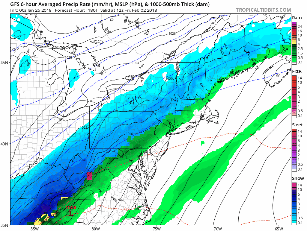
FRIDAY- Groundhog Day STORM
This looks like a rain event changing to snow as Low Pressure develops and passes through during the day. I DO NOT like to show specifics this far away, but there has been a consistency with this for a few days. Please give it some time to evolve and then we can break down timing and totals…. Any little shift could adjust the entire event for more or fall apart.
Outlook
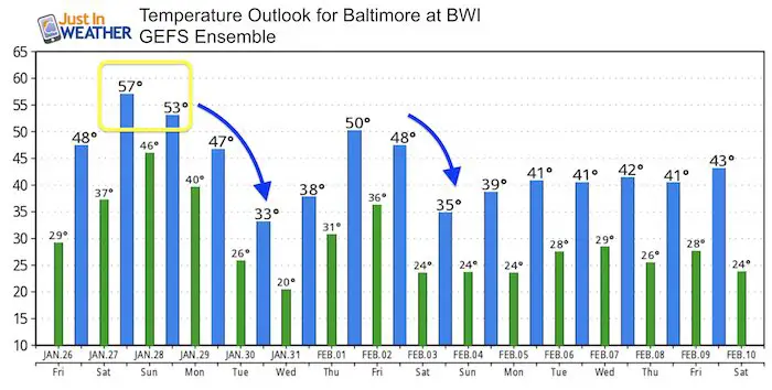
Temperature Trend
Please note:
- This weekend will be mild
- Monday and Friday will both has falling temperatures during the day
- February: When the model shows near normal conditions, it does not have a clear signal how cold the air mass wil be. I see a colder trend into Mid February .
FITF Gear

Please share your thoughts, best weather pics/video, or just keep in touch via social media
-
Facebook: Justin Berk, Meteorologist
-
Twitter: @JustinWeather
-
Instagram: justinweather
Snowstix- We Need You To Measure Snow Too
We are giving 10% of each sale to programs that benefit pediatric oncology patients.

 Get the award winning Kid Weather App I made with my oldest son and support our love for science, weather, and technology. Our 3 year anniversary of the release and our contribution to STEM education is this November. It has been downloaded in 60 countries, and works in both temperature scales. With your support we can expand on the fun introduction to science and real weather.
Keep In Touch All Winter
Click here to sign up for email alerts…. Just in case you don’t get the post on your social media feed
Also See:
My Winter Outlook 2017-2018 for more snow
La Nina Formed: What it could mean to our winter
NOAA Winter Outlook: Not The Best But Not The Worst For Snow
Two Farmers Almanacs Winter 2018 Outlooks
Winter Weather Folkore: Suggestions from Animals and Crops
First Frost and Freeze Dates For Maryland (southern PA and northern VA)
My Preliminary Winter Outlook Notes
Low Snow Winters In Baltimore: To Repeat Or Not Repeat
NOAA Ranks Blizzard 2016 4th Worst Snowstorm On Record
Blizzard 2016 Record Top Snowstorm: Area Totals
Extreme Weather of 2015 balanced out on both ends