Monday January 15 2018
Light snow is on the way and the arctic air in place will help chill the ground and support maximum stickage…. Today will just be cold as some flurries may develop. It will be a developing band of snow that slowly moves in Tuesday that will bring us a general 1 to 3 inch accumulation. The issues may being Tuesday morning in western Maryland and north into southern Pennsylvania. This will spread into the Baltimore suburbs Tuesday evening and be an issue for travel on Wednesday morning. Delmarva and the beaches will deal with this most of the day and afternoon on Wednesday. Here’s the quick breakdown.
Stats For January 15
Normal High: 41ºF
Record High: 78ºF in 1932
Normal Low: 24ºF
*Former Record Low: -2ºF in 1964
Snow Record: 3.4″ in 1957
Seasonal Snow To Date (at BWI): 5.2″
Sunrise: 7:24 AM
Sunset 5:08 PM
*Daylight = 1:26 longer than yesterday
*Bay Water Temperature = 33ºF at Thomas Pt. Light House.
Keep In Touch All Winter
Click here to sign up for email alerts…. Just in case you don’t get the post on your social media feed
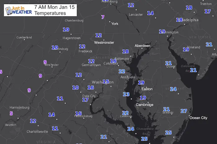
This Morning
We are in the deep freeze…
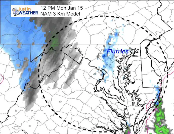
Today: Flurries
There will be flurries and light snow, but mostly for ambience today.
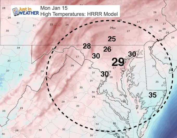
This Afternoon
Deep Freeze Holds: Highs stay in the mid 20s to low 30s. So the ground will be chilled enough for any flakes to stick when they arrive….
Tuesday Morning Snow
The slow moving system on the way could bring morning snow tomorrow to mountains of western Maryland and southern PA. There is potential for snow from Hagerstown to Harrisburg…. maybe into York and Lancaster. This is making a harp cut so this will be something to watch closely for any adjustment.
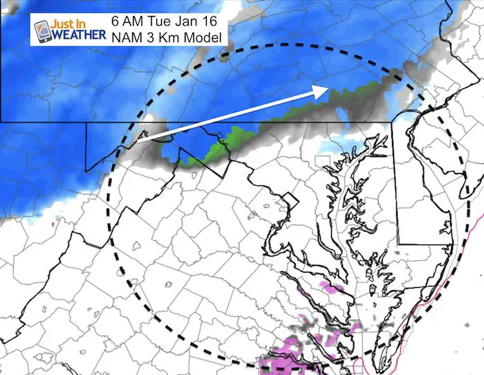
Snow Tuesday Evening-Wednesday
There will be an evolving and slow moving band of snow. It should reach the northern suburbs of Baltimore by Tuesday evening. The speed of the progress will determine how much will accumulate. I would plan on paying attention to school activities, etc Tuesday evening north of Baltimore. But it will be a Wednesday morning issue for metro areas and Delmarva.
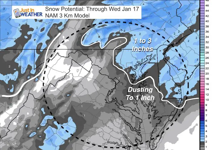
—> slider: NAM 3 Km Model
[metaslider id=56868]
Snow Potential
This is the NAM 3 Km Model showing a general 1 to 3 inches. I will post my call for snowfall this evening.
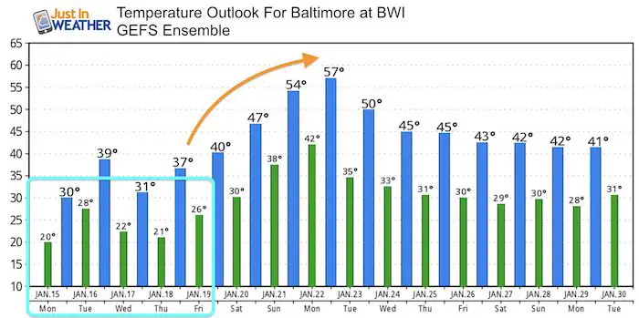
Temperature Outlook
Please share your thoughts, best weather pics/video, or just keep in touch via social media
-
Facebook: Justin Berk, Meteorologist
-
Twitter: @JustinWeather
-
Instagram: justinweather
Shirts
I do these for fun, but also:
A Portion of the proceeds will go to Integrated Wellness programs for Pediatric Oncology Patients
May The Flakes Be With You- Limited Edition Shirt

FITF Gear

Snowstix- We Need You To Measure Snow Too
We are giving 10% of each sale to programs that benefit pediatric oncology patients.

 Get the award winning Kid Weather App I made with my oldest son and support our love for science, weather, and technology. Our 3 year anniversary of the release and our contribution to STEM education is this November. It has been downloaded in 60 countries, and works in both temperature scales. With your support we can expand on the fun introduction to science and real weather.
Keep In Touch All Winter
Click here to sign up for email alerts…. Just in case you don’t get the post on your social media feed
Also See:
My Winter Outlook 2017-2018 for more snow
La Nina Formed: What it could mean to our winter
NOAA Winter Outlook: Not The Best But Not The Worst For Snow
Two Farmers Almanacs Winter 2018 Outlooks
Winter Weather Folkore: Suggestions from Animals and Crops
First Frost and Freeze Dates For Maryland (southern PA and northern VA)
My Preliminary Winter Outlook Notes
Low Snow Winters In Baltimore: To Repeat Or Not Repeat
NOAA Ranks Blizzard 2016 4th Worst Snowstorm On Record