Friday January 12 2018
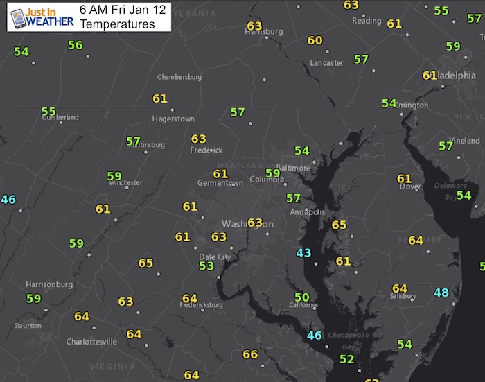
You may already know some of the weather just by hear the wind and rain banging against your window. Moderate rain had moved in overnight, but the fog may be the added element to slow your commute down even more this morning. There will be periods of moderate rain today, but also a few hours at a time that are dry. Those are likely in the afternoon and evening.
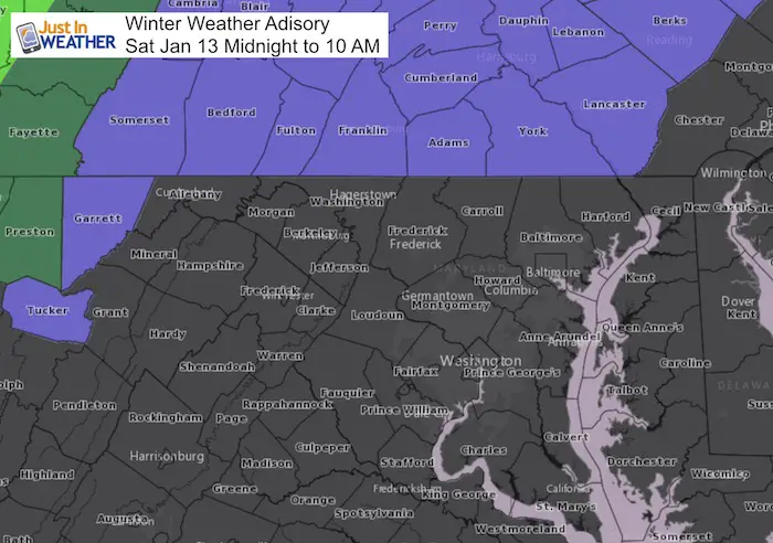
Tonight is when the weather gets more dramatic. Heavier rain might have some rumbles of thunder, then the cold front swings through. Temperature at midnight could be in the lower 60s, but near or below freezing when you wake up on Saturday morning… especially near and north of Baltimore. That is where this may end with ice and snow. A Winter Weather Advisory has been issued for southern PA, but the northern Maryland counties might get in on some action… Then we all set up for a cold weekend.
Stats For January 12
Normal High: 41ºF
Record High: 70ºF in 2017
Normal Low: 24ºF
*Former Record Low: 1ºF in 1981
Snow Record: 6.0″ in 1996
Seasonal Snow To Date (at BWI): 5.2″
Sunrise: 7:25 AM
Sunset 5:05 PM
*Daylight = 1:17 longer than yesterday
*Bay Water Temperature = 33ºF at Thomas Pt. Light House.
Keep In Touch All Winter
Click here to sign up for email alerts…. Just in case you don’t get the post on your social media feed
This Morning
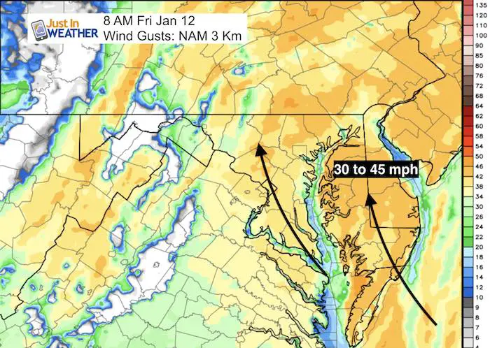
Wind Gusts
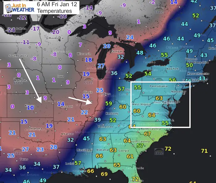
Wider View
This temperature contrast is the really for the strong winds feeding into the storm
Friday Evening
Periods of rain sounds cliche, but there will be moderate rain this morning and again tonight. But there will be a few hours at a time with no rain. We should get these dry hours durning the afternoon and evening.
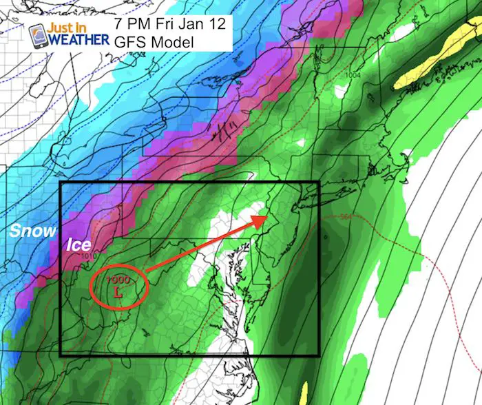
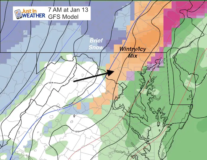
The track of Low Pressure into southern PA will help to bring the cold air in behind it and some wintry mix Saturday morning.
Saturday Morning
Winter Weather Advisory
Dramatic Temperature Drop
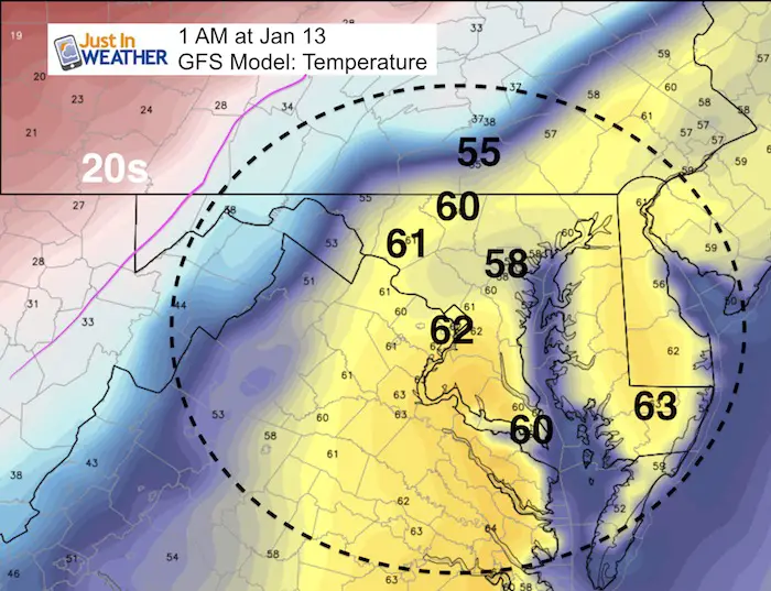
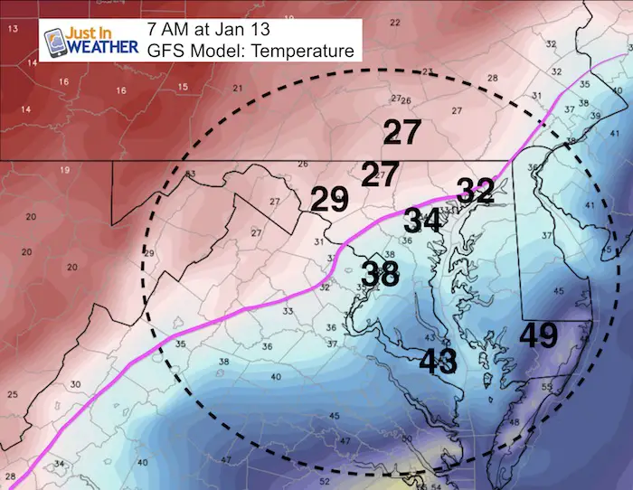
Temperature Outlook
Reminder that the high temperature for Saturday will be at midnight, Most of the day will remain below freezing, and turn colder Sunday/Monday.
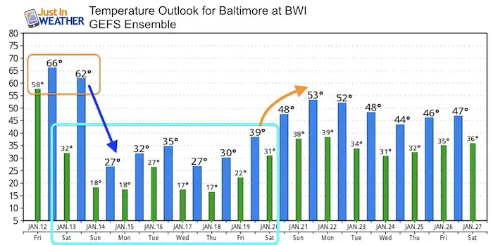
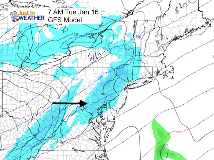
Snow Next Week?
The quick moving system expect on Tuesday does not have a lot of moisture with it. At this time I would suggest a period of light snow during the day
Please share your thoughts, best weather pics/video, or just keep in touch via social media
-
Facebook: Justin Berk, Meteorologist
-
Twitter: @JustinWeather
-
Instagram: justinweather
Shirts
I do these for fun, but also:
A Portion of the proceeds will go to Integrated Wellness programs for Pediatric Oncology Patients
May The Flakes Be With You- Limited Edition Shirt

FITF Gear

Snowstix- We Need You To Measure Snow Too
We are giving 10% of each sale to programs that benefit pediatric oncology patients.

 Get the award winning Kid Weather App I made with my oldest son and support our love for science, weather, and technology. Our 3 year anniversary of the release and our contribution to STEM education is this November. It has been downloaded in 60 countries, and works in both temperature scales. With your support we can expand on the fun introduction to science and real weather.
Keep In Touch All Winter
Click here to sign up for email alerts…. Just in case you don’t get the post on your social media feed
Also See:
My Winter Outlook 2017-2018 for more snow
La Nina Formed: What it could mean to our winter
NOAA Winter Outlook: Not The Best But Not The Worst For Snow
Two Farmers Almanacs Winter 2018 Outlooks
Winter Weather Folkore: Suggestions from Animals and Crops
First Frost and Freeze Dates For Maryland (southern PA and northern VA)
My Preliminary Winter Outlook Notes
Low Snow Winters In Baltimore: To Repeat Or Not Repeat
NOAA Ranks Blizzard 2016 4th Worst Snowstorm On Record