 January 9 2018
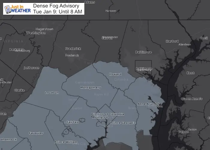
A Dense Fog Advisory is in effect for parts of central Maryland until 8 AM. After the rain stopped, the sky cleared out overnight. This allowed some cooling (for parts of our region) that combined with the west ground helped to saturate the air. Fog may be thick, under 1 mile in places, further hindering the traveling this morning. This fog may also limit the thawing in the early morning hours, but we will all get in to disperse and we all warm up today.
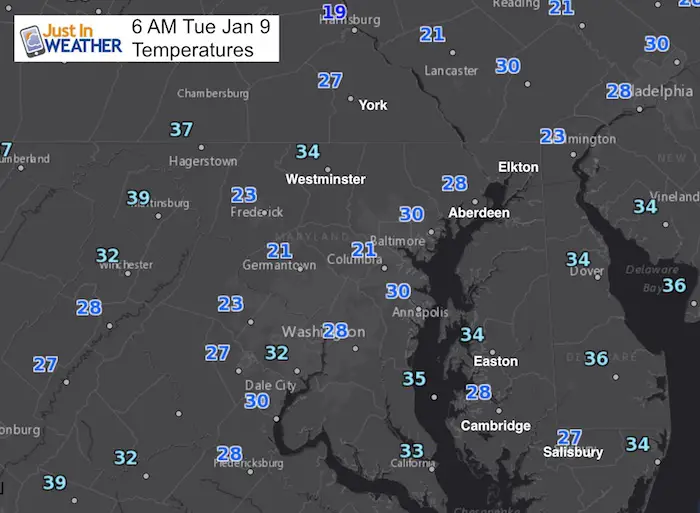
Temperatures:
The ground is frozen, so the air temperatures can be misleading about your ice. Many area schools have at least a 2 hour delay.
The sky cleared overnight. The contrast of the warmer air that attempted to move in over frozen ground and ice covered water has led to a wide range of conditions this morning. Some places are clear nearby to the foggy zones. This may be a demonstration that warm air rising, especially with light wind and clear sky at night. Places like Westminster are now in the mid 30s but BWI is in the lower 20s. Parts of York County range from the teens to upper 20s. Temperatures near Annapolis dropped back below freezing.
Stats For January 9
Normal High: 41ºF
Record High: 75ºF in 1937
Normal Low: 24ºF
*Former Record Low: 2ºF in 1970
Snow Record: 4.1″ in 1996
Seasonal Snow To Date (at BWI): 5.2″
Sunrise: 7:26 AM
Sunset 5:02 PM
*Daylight = 1:07 longer than yesterday
*Bay Water Temperature = 32ºF at Thomas Pt. Light House.
Keep In Touch All Winter
Click here to sign up for email alerts…. Just in case you don’t get the post on your social media feed
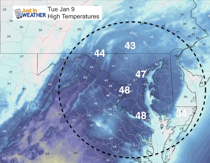
Today: Warming Up!
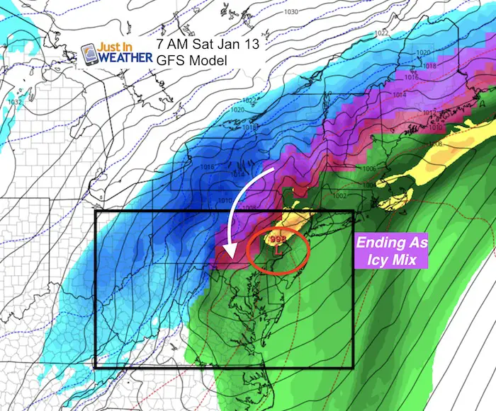
End Of Week Storm:
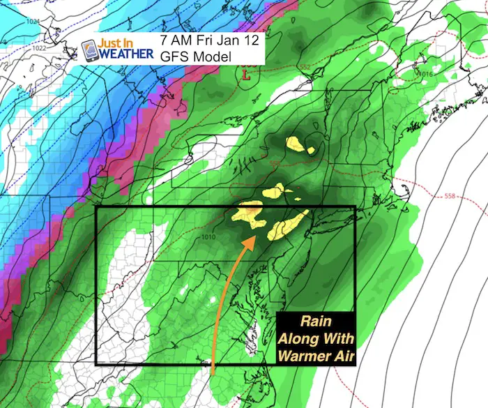
Friday Rain
Saturday: May End With Ice North/West
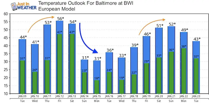
The Big January Thaw
The Jet Stream will relax and allow warmer air to spread in this week. The next storm will help to push in the warm air with rain in Friday, then followed by another freeze next weekend.
Shirts
I do these for fun, but also:
A Portion of the proceeds will go to Integrated Wellness programs for Pediatric Oncology Patients
May The Flakes Be With You- Limited Edition Shirt

Faith in DE Flakes
I survived the Blizzard of 2018- Special Edition shirt for Delaware. Sussex County was the big snow winner.
Please share your thoughts, best weather pics/video, or just keep in touch via social media
-
Facebook: Justin Berk, Meteorologist
-
Twitter: @JustinWeather
-
Instagram: justinweather
FITF Gear
Snowstix- We Need You To Measure Snow Too
We are giving 10% of each sale to programs that benefit pediatric oncology patients.
 Get the award winning Kid Weather App I made with my oldest son and support our love for science, weather, and technology. Our 3 year anniversary of the release and our contribution to STEM education is this November. It has been downloaded in 60 countries, and works in both temperature scales. With your support we can expand on the fun introduction to science and real weather.
Keep In Touch All Winter
Click here to sign up for email alerts…. Just in case you don’t get the post on your social media feed
Also See:
My Winter Outlook 2017-2018 for more snow
La Nina Formed: What it could mean to our winter
NOAA Winter Outlook: Not The Best But Not The Worst For Snow
Two Farmers Almanacs Winter 2018 Outlooks
Winter Weather Folkore: Suggestions from Animals and Crops
First Frost and Freeze Dates For Maryland (southern PA and northern VA)
My Preliminary Winter Outlook Notes
Low Snow Winters In Baltimore: To Repeat Or Not Repeat
NOAA Ranks Blizzard 2016 4th Worst Snowstorm On Record
Blizzard 2016 Record Top Snowstorm: Area Totals
Extreme Weather of 2015 balanced out on both ends

